Approach Charts
| FltPlan does not have IFR approach charts available for PAOH. |
Current Weather/Notams (Metars, TAFs, Notams, NWS Forecast, PIREPS, and nearby weather)
Customs Information Send updates to Support@FltPlan.com
Customs Not Available
Database effective 04/18/2024
Airport Diagram might not be current.
|
| Facility Name: | HOONAH |
| City Name: | HOONAH |
| County: | ANGOON |
| State abbrev: | AK |
| State Name: | ALASKA |
| | |
| Ownership: | PUBLICLY OWNED |
| Use: | OPEN TO THE PUBLIC |
| Owner's Name: | ALASKA DOT&PF SOUTHCOAST REGION |
| Address: | P.O. BOX 112506 |
| | JUNEAU, AK 99811-2506 |
| Owner's Phone: | (907) 945-3426 |
| | |
| Manager's Name: | KEN MESERVE |
| Address: | 6860 GLACIER HWY |
| | JUNEAU, AK 99801-7999 |
| Phone: | 907-945-3426 |
| | |
| FAA Region: | ALASKA |
| FAA Field Office: | NONE |
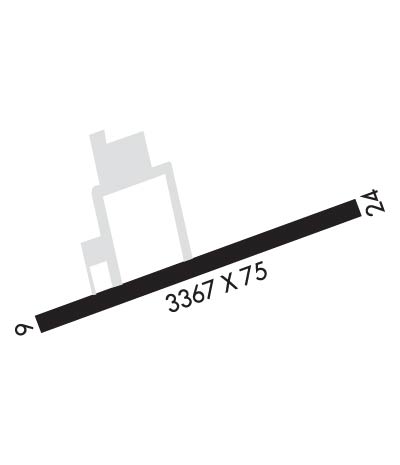
Runway Identifications
Runway Identification: 06/24Length: 3367 ft
Width: 75 ft
Surface: ASPHALT-GOOD CONDITION
Edge lights: Medium IntensityTreatment: NONE
Weight: PCN 12 /F/C/Y/T
| | Runway: 06 | | Runway: 24 |
| Mag heading: | 58° | Mag heading: | 238° |
| Rwy Slope: | .19% Up | Rwy Slope: | -.19% Down |
| Approach: | | Approach: | |
| Pattern: | Right Traffic | Pattern: | Left Traffic |
| Markings: | NONSTANDARD | Markings: | NONSTANDARD |
| Marking Condition: | GOOD; NSTD; IREG SPACED RWY EDGE LGTS. | Marking Condition: | GOOD; NSTD; IREG SPACED RWY EDGE LGTS. |
| Arresting Dev: | | Arresting Dev: | |
| Lat & Long: | N5805.7 W13525.0 | Lat. & Long.: | N5805.8 W13524.0 |
| Elev: | 15.1 ft. MSL | Elev: | 21.5 ft. MSL |
| TCH: | 35 ft. AGL | TCH: | |
| Visual Glide Path: | 4.00 degrees | Visual Glide Path: | |
| Displaced Threshold: | No | Displaced Threshold: | No |
| Touchdown Zone: | YES | Touchdown Zone: | YES |
| Touchdown Elev.: | 19.0 feet | Touchdown Elev.: | 21.5 feet |
| Visual Glide Slope: | 4-Light PAPI on LEFT side of Runway; RWY 06 PAPI UNUSBL BYD 2 DEG R OF CNTRLN; PAPI UNUSBL BYD 5.8 NM; PAPI DOES NOT PRVD OBSTN CLNC BYD 5.8 NM. | Visual Glide Slope: | |
| RVR Equipment: | | RVR Equipment: | |
| RVV Equipment: | NO | RVV Equipment: | NO |
| Approach Lights: | | Approach Lights: | |
| REIL: | YES | REIL: | YES |
| Centerline Lights: | NO | Centerline Lights: | NO |
| Touchdown lights: | NO | Touchdown lights: | NO |
| Runway Category: | Runway with a Visual Approach | Runway Category: | Runway with a Visual Approach |
| Declared Distances: | | Declared Distances: | |
| Obstructions: | TREES | Obstructions: | TREES |
| Marked: | NOT Marked/Lighted | Marked: | NOT Marked/Lighted |
| Clearance slope: | 8:1 | Clearance slope: | |
| Obstruction height: | 105 feet AGL | Obstruction height: | 18 feet AGL |
| Dist. from runway: | 1080 feet | Dist. from runway: | 200 feet |
| Centerline offset: | 356 right of centerline | Centerline offset: | 120 feet right of centerline |
| Comments: | | Comments: | |

