Approach Charts
| FltPlan does not have IFR approach charts available for PAOC. |
Current Weather/Notams (Metars, TAFs, Notams, NWS Forecast, PIREPS, and nearby weather)
Customs Information Send updates to Support@FltPlan.com
Customs Not Available
Database effective 05/16/2024
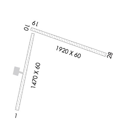
Airport Diagram might not be current.
|
| Facility Name: | PORTAGE CREEK |
| City Name: | PORTAGE CREEK |
| County: | DILLINGHAM |
| State abbrev: | AK |
| State Name: | ALASKA |
| | |
| Ownership: | PUBLICLY OWNED |
| Use: | OPEN TO THE PUBLIC |
| Owner's Name: | ALASKA DOT&PF CENTRAL REGION |
| Address: | PO BOX 196900 |
| | ANCHORAGE, AK 99519-6900 |
| Owner's Phone: | 907-269-0760 |
| | |
| Manager's Name: | JON TAYLOR |
| Address: | BOX 250 |
| | DILLINGHAM, AK 99576 |
| Phone: | 907-842-5511 |
| | |
| FAA Region: | ALASKA |
| FAA Field Office: | NONE |
Runway Identifications
Runway Identification: 01/19Length: 1470 ft
Width: 60 ft
Surface: NATURAL SOIL-GOOD CONDITION
Edge lights: Treatment: NONE
| | Runway: 01 | | Runway: 19 |
| Mag heading: | 6° | Mag heading: | 186° |
| Rwy Slope: | 1.42% Up | Rwy Slope: | -1.42% Down |
| Approach: | | Approach: | |
| Pattern: | Left Traffic | Pattern: | Left Traffic |
| Markings: | | Markings: | |
| Marking Condition: | RWY 01/19 MKD WITH REFLECTIVE ORANGE CONES. | Marking Condition: | |
| Arresting Dev: | | Arresting Dev: | |
| Lat & Long: | N5854.2 W15743.0 | Lat. & Long.: | N5854.5 W15742.8 |
| Elev: | 79.8 ft. MSL | Elev: | 100.7 ft. MSL |
| TCH: | | TCH: | |
| Visual Glide Path: | | Visual Glide Path: | |
| Displaced Threshold: | No | Displaced Threshold: | No |
| Touchdown Zone: | YES | Touchdown Zone: | YES |
| Touchdown Elev.: | 101.0 feet | Touchdown Elev.: | 101.0 feet |
| Visual Glide Slope: | | Visual Glide Slope: | |
| RVR Equipment: | | RVR Equipment: | |
| RVV Equipment: | NO | RVV Equipment: | NO |
| Approach Lights: | | Approach Lights: | |
| REIL: | NO | REIL: | NO |
| Centerline Lights: | NO | Centerline Lights: | NO |
| Touchdown lights: | NO | Touchdown lights: | NO |
| Runway Category: | Runway with a Visual Approach | Runway Category: | Runway with a Visual Approach |
| Declared Distances: | | Declared Distances: | |
| Obstructions: | TREES | Obstructions: | BRUSH |
| Marked: | NOT Marked/Lighted | Marked: | NOT Marked/Lighted |
| Clearance slope: | | Clearance slope: | |
| Obstruction height: | 25 feet AGL | Obstruction height: | 6 feet AGL |
| Dist. from runway: | 0 feet | Dist. from runway: | 0 feet |
| Centerline offset: | 120 right of centerline | Centerline offset: | 85 feet right of centerline |
| Comments: | | Comments: | |
Runway Identification: 10/28Length: 1920 ft
Width: 60 ft
Surface: NATURAL SOIL-FAIR CONDITION
Edge lights: Treatment: NONE
| | Runway: 10 | | Runway: 28 |
| Mag heading: | 91° | Mag heading: | 271° |
| Rwy Slope: | 1.50% Up | Rwy Slope: | -1.50% Down |
| Approach: | | Approach: | |
| Pattern: | Left Traffic | Pattern: | Left Traffic |
| Markings: | | Markings: | |
| Marking Condition: | RWY MKD WITH REFLECTIVE ORANGE CONES. | Marking Condition: | |
| Arresting Dev: | | Arresting Dev: | |
| Lat & Long: | N5854.5 W15742.8 | Lat. & Long.: | N5854.4 W15742.2 |
| Elev: | 99.7 ft. MSL | Elev: | 128.5 ft. MSL |
| TCH: | | TCH: | |
| Visual Glide Path: | | Visual Glide Path: | |
| Displaced Threshold: | No | Displaced Threshold: | No |
| Touchdown Zone: | YES | Touchdown Zone: | YES |
| Touchdown Elev.: | 129.0 feet | Touchdown Elev.: | 129.0 feet |
| Visual Glide Slope: | | Visual Glide Slope: | |
| RVR Equipment: | | RVR Equipment: | |
| RVV Equipment: | NO | RVV Equipment: | NO |
| Approach Lights: | | Approach Lights: | |
| REIL: | NO | REIL: | NO |
| Centerline Lights: | NO | Centerline Lights: | NO |
| Touchdown lights: | NO | Touchdown lights: | NO |
| Runway Category: | Runway with a Visual Approach | Runway Category: | Runway with a Visual Approach |
| Declared Distances: | | Declared Distances: | |
| Obstructions: | BRUSH | Obstructions: | BRUSH |
| Marked: | NOT Marked/Lighted | Marked: | NOT Marked/Lighted |
| Clearance slope: | | Clearance slope: | |
| Obstruction height: | 8 feet AGL | Obstruction height: | 10 feet AGL |
| Dist. from runway: | 0 feet | Dist. from runway: | 0 feet |
| Centerline offset: | | Centerline offset: | 50 feet right of centerline |
| Comments: | | Comments: | |

