
| ||||||||||||||||||||||||||||||||
| ||||||||||||||||||||||||||||||||
| ||||||||||||||||||||||||||||||||
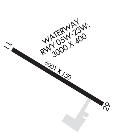
| Rwy | Rwy | |||||||
| 6200x100 | 5800' | 109.70 - 109° | 6200x100 | 5800' | ||||
| Runway ID | Single Wheel | Double Wheel | Double Tandem Wheel | Dual Double Wheel |
| 11/29 | 30,000 | 120,000 | 126,000 | N/A |
| These numbers are Advisory and are not limits. The Airport Manager should have more accurate Weight Limits | ||||
 Airport Diagram might not be current. | |
| Facility Name: | ANIAK |
| City Name: | ANIAK |
| County: | BETHEL |
| State abbrev: | AK |
| State Name: | ALASKA |
| Ownership: | PUBLICLY OWNED |
| Use: | OPEN TO THE PUBLIC |
| Owner's Name: | ALASKA DOT&PF CENTRAL REGION |
| Address: | PO BOX 196900 |
| ANCHORAGE, AK 99519-6900 | |
| Owner's Phone: | 907-269-0749 |
| Manager's Name: | ROXANNE EVAN |
| Address: | PO BOX 73, ANIAK AIRPORT |
| ANIAK, AK 99577 | |
| Phone: | 907-675-4345 |
| FAA Region: | ALASKA |
| FAA Field Office: | NONE |
| Date | Sunrise | Sunset |
|---|---|---|
| 04/19/24 Friday | 7:00 | 22:15 |
| 04/20/24 Saturday | 6:57 | 22:18 |
| 04/21/24 Sunday | 6:54 | 22:21 |
| 04/22/24 Monday | 6:51 | 22:23 |
| 04/23/24 Tuesday | 6:48 | 22:26 |
| 04/24/24 Wednesday | 6:45 | 22:29 |
| 04/25/24 Thursday | 6:42 | 22:31 |
| 04/26/24 Friday | 6:39 | 22:34 |
| 04/27/24 Saturday | 6:36 | 22:37 |
| 04/28/24 Sunday | 6:33 | 22:40 |
| 04/29/24 Monday | 6:30 | 22:42 |
| 04/30/24 Tuesday | 6:27 | 22:45 |
| 05/01/24 Wednesday | 6:24 | 22:48 |
| 05/02/24 Thursday | 6:21 | 22:50 |
| Airport Attendance Schedule | 1 MAY- 14 OCT MON- FRI 0730L-1630L, 15 OCT- 30 APR SUN-SAT 0730L-1630L |
| Airport Status | OPERATIONAL (This Status can change at any time - please check NOTAMS) |
| Airport Lighting Schedule | ACTVT MALSF RWY 11; PAPI RWY 29; HIRL RWY 11/29 - CTAF. |
| Airport Storage Available | Tie Downs |
| Extra Services Available | Cargo Handling |
| Wind Indicator | YES - (lighted) |
| Control Tower | NO |
| CTAF Frequency | 122.100 |
| Unicom Frequency | |
| Rotating Beacon Color | WG |
| Segmented Circle | YES |
| Landing Fee | NO |
| Airport Inspected | STATE - performed by PRIVATE CONTRACT PERSONNEL |
| Inspection Date | 08/02/2023 |
| Type of Fuel Available | Grade 100LL, JET A (freeze point -40C); -10FUEL AVBL - CTAF OR 907-675-4295. |
| Airframe Repair Service | MINOR |
| Power Plant Repair Service | MINOR |
| Latitude | N6134.9 |
| Longitude | W15932.7 (ESTIMATED) |
| Arpt Elevation | 96ft (SURVEYED) |
| Magnetic Variation | 12E |
| 0 miles S | of ANIAK |
| Traffic Pattern Altitude | |
| Sectional Chart | MC GRATH |
| Operations (Reported) | Yearly | Avg. Daily |
|---|---|---|
| General Aviation Transient | 500 | 1 |
| General Aviation Local | 300 | 1 |
| Air Taxi | 1750 | 5 |
| Commerical | 0 | 0 |
| Commuter | 0 | 0 |
| Military | 50 | 0 |
| Aircraft based on Field | |
|---|---|
| General Aviation Singles | 17 |
| General Aviation Multi | 1 |
| Jet Aircraft | 0 |
| General Aviation Helicopters | 0 |
| Military Aircraft | 0 |
| Gliders | 0 |
| Ultralights | 0 |
| FSS on field | NO |
| FSS tie-in | KENAI |
| FSS Phone | 1-800-866-864-1737 |
| Who issues Notams | ANI |
| Notam D service at airport | YES |
| ARTCC Name | ANCHORAGE |
| Airport Certification | |
| Aircraft Rescue & Firefighting Index | None |
| Airport of Entry | No |
| Custom Landing Rights | No |
| Joint Civil/Military | No |
| Military Landing rights | No |
| NATIONAL PLAN OF INTEGRATED AIRPORT SYSTEMS (NPIAS) |
| SURPLUS PROPERTY AGREEMENT UNDER REGULATION 16-WAA |
| GRANT AGREEMENTS UNDER FAAP/ADAP/AIP |
| SURPLUS PROPERTY AGREEMENT UNDER PUBLIC LAW 289 |
| ASSURANCES PURSUANT TO TITLE VI, CIVIL RIGHTS ACT OF 1964 |
| LOCK WHEEL TURNS NA ALL SFCS. |
| FUEL TRUCK ACES AVBL SLOUGH BEACH E OF RAMP. |
| ARPT SAND LRGR GRADATION THAN FAA RCMDD/SEE AC150/5200-30. |
| PAEW ON THE RWY. |
| TSNT PRKG AVBL, MRKD WITH GREEN CONES. |
| WX CAMERA AVBL ON INTERNET AT HTTPS://WEATHERCAMS.FAA.GOV/. |
| COLD TEMPERATURE AIRPORT. ALTITUDE CORRECTION REQUIRED AT OR BELOW -38C. |
| RWY 11/2 9 PCR VALUE: 405/F/A/X/T |
Airport Communications & Frequencies:
| |||||||
| Runway: 11 | Runway: 29 | ||
| Mag heading: | 109° | Mag heading: | 289° |
| Rwy Slope: | .00% Down | Rwy Slope: | .00% Up |
| Approach: | ILS/DME | Approach: | |
| Pattern: | Left Traffic | Pattern: | Left Traffic |
| Markings: | PRECISION INSTRUMENT | Markings: | NONPRECISION INSTRUMENT |
| Marking Condition: | GOOD | Marking Condition: | GOOD |
| Arresting Dev: | Arresting Dev: | ||
| Lat & Long: | N6135.1 W15933.6 | Lat. & Long.: | N6134.6 W15931.8 |
| Elev: | 96.8 ft. MSL | Elev: | 96.7 ft. MSL |
| TCH: | TCH: | 40 ft. AGL | |
| Visual Glide Path: | Visual Glide Path: | 3.00 degrees | |
| Displaced Threshold: | 400 feet | Displaced Threshold: | 400 feet |
| Touchdown Zone: | YES | Touchdown Zone: | YES |
| Touchdown Elev.: | 96.7 feet | Touchdown Elev.: | 96.8 feet |
| Visual Glide Slope: | Visual Glide Slope: | 4-Light PAPI on RIGHT side of Runway | |
| RVR Equipment: | RVR Equipment: | ||
| RVV Equipment: | NO | RVV Equipment: | NO |
| Approach Lights: | MALSF - 1,400 foot medium intensity approach lighting system with sequenced flashers | Approach Lights: | |
| REIL: | NO | REIL: | NO |
| Centerline Lights: | NO | Centerline Lights: | NO |
| Touchdown lights: | NO | Touchdown lights: | NO |
| Runway Category: | Precision Instrument Runway | Runway Category: | Runway with a Non-precision Approach having visibility minimums greater than 3/4 mile |
| Declared Distances: | TORA:5800' TODA:6200' ASDA:5800' LDA:5400' | Declared Distances: | TORA:5800' TODA:6200' ASDA:5800' LDA:5400' |
| Obstructions: | ROAD | Obstructions: | POLE |
| Marked: | NOT Marked/Lighted | Marked: | NOT Marked/Lighted |
| Clearance slope: | 23:1 | Clearance slope: | 3:1 |
| Obstruction height: | 7 feet AGL | Obstruction height: | 30 feet AGL |
| Dist. from runway: | 364 feet | Dist. from runway: | 310 feet |
| Centerline offset: | 525 left of centerline | Centerline offset: | 513 feet right of centerline |
| Comments: | Comments: |