Current Weather/Notams (Metars, TAFs, Notams, NWS Forecast, PIREPS, and nearby weather)
Customs Information Send updates to Support@FltPlan.com
Customs Not Available
Database effective 05/16/2024
Airport Diagram might not be current.
|
| Facility Name: | MERRILL FLD |
| City Name: | ANCHORAGE |
| County: | ANCHORAGE |
| State abbrev: | AK |
| State Name: | ALASKA |
| | |
| Ownership: | PUBLICLY OWNED |
| Use: | OPEN TO THE PUBLIC |
| Owner's Name: | MUNICIPALITY OF ANCHORAGE |
| Address: | 800 MERRIL FIELD DR. |
| | ANCHORAGE, AK 99501-4129 |
| Owner's Phone: | 907-343-6303 |
| | |
| Manager's Name: | RICH SEWELL, AAE |
| Address: | MERRILL FIELD AIRPORT, 800 MERRIL FIELD DR |
| | ANCHORAGE, AK 99501-4129 |
| Phone: | 907-343-6303 |
| | |
| FAA Region: | ALASKA |
| FAA Field Office: | NONE |
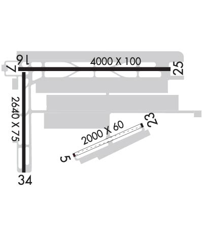
Runway Identifications
Runway Identification: 05/23Length: 2000 ft
Width: 60 ft
Surface: ASPHALT-GOOD CONDITION
Edge lights: Treatment: NONE
| | Runway: 05 | | Runway: 23 |
| Mag heading: | 47° | Mag heading: | 227° |
| Rwy Slope: | .24% Up | Rwy Slope: | -.24% Down |
| Approach: | | Approach: | |
| Pattern: | Left Traffic | Pattern: | Left Traffic |
| Markings: | | Markings: | |
| Marking Condition: | GOOD | Marking Condition: | GOOD |
| Arresting Dev: | | Arresting Dev: | |
| Lat & Long: | N6112.6 W14950.7 | Lat. & Long.: | N6112.7 W14950.1 |
| Elev: | 133.2 ft. MSL | Elev: | 138.0 ft. MSL |
| TCH: | | TCH: | |
| Visual Glide Path: | | Visual Glide Path: | |
| Displaced Threshold: | No | Displaced Threshold: | No |
| Touchdown Zone: | YES | Touchdown Zone: | YES |
| Touchdown Elev.: | 138.0 feet | Touchdown Elev.: | 138.0 feet |
| Visual Glide Slope: | | Visual Glide Slope: | |
| RVR Equipment: | | RVR Equipment: | |
| RVV Equipment: | NO | RVV Equipment: | NO |
| Approach Lights: | | Approach Lights: | |
| REIL: | NO | REIL: | NO |
| Centerline Lights: | NO | Centerline Lights: | NO |
| Touchdown lights: | NO | Touchdown lights: | NO |
| Runway Category: | Runway with a Visual Approach | Runway Category: | Runway with a Visual Approach |
| Declared Distances: | | Declared Distances: | |
| Obstructions: | TREE | Obstructions: | ROAD |
| Marked: | NOT Marked/Lighted | Marked: | NOT Marked/Lighted |
| Clearance slope: | 10:1 | Clearance slope: | 1:1 |
| Obstruction height: | 9 feet AGL | Obstruction height: | 15 feet AGL |
| Dist. from runway: | 91 feet | Dist. from runway: | 0 feet |
| Centerline offset: | 80 left of centerline | Centerline offset: | 125 feet right of centerline |
| Comments: | | Comments: | |
Runway Identification: 07/25Length: 4000 ft
Width: 100 ft
Surface: ASPHALT-GOOD CONDITION
Edge lights: Medium IntensityTreatment: NONE
| | Runway: 07 | | Runway: 25 |
| Mag heading: | 71° | Mag heading: | 251° |
| Rwy Slope: | .30% Up | Rwy Slope: | -.30% Down |
| Approach: | | Approach: | |
| Pattern: | Right Traffic | Pattern: | Left Traffic |
| Markings: | PRECISION INSTRUMENT | Markings: | PRECISION INSTRUMENT |
| Marking Condition: | GOOD | Marking Condition: | GOOD |
| Arresting Dev: | | Arresting Dev: | |
| Lat & Long: | N6113.0 W14951.2 | Lat. & Long.: | N6113.0 W14949.8 |
| Elev: | 131.0 ft. MSL | Elev: | 143.1 ft. MSL |
| TCH: | 43 ft. AGL | TCH: | 21 ft. AGL |
| Visual Glide Path: | 3.75 degrees | Visual Glide Path: | 3.00 degrees |
| Displaced Threshold: | No | Displaced Threshold: | No |
| Touchdown Zone: | YES | Touchdown Zone: | YES |
| Touchdown Elev.: | 140.3 feet | Touchdown Elev.: | 137.3 feet |
| Visual Glide Slope: | 2-Box VASI on LEFT side of Runway | Visual Glide Slope: | 2-Box VASI on LEFT side of Runway |
| RVR Equipment: | | RVR Equipment: | |
| RVV Equipment: | NO | RVV Equipment: | NO |
| Approach Lights: | | Approach Lights: | |
| REIL: | YES | REIL: | YES |
| Centerline Lights: | NO | Centerline Lights: | NO |
| Touchdown lights: | NO | Touchdown lights: | NO |
| Runway Category: | Runway with a Visual Approach | Runway Category: | Runway with a Visual Approach |
| Declared Distances: | | Declared Distances: | |
| Obstructions: | POLE | Obstructions: | BLDG |
| Marked: | NOT Marked/Lighted | Marked: | NOT Marked/Lighted |
| Clearance slope: | 1:1 | Clearance slope: | 5:1 |
| Obstruction height: | 32 feet AGL | Obstruction height: | 37 feet AGL |
| Dist. from runway: | 245 feet | Dist. from runway: | 410 feet |
| Centerline offset: | 300 right of centerline | Centerline offset: | 305 feet right of centerline |
| Comments: | | Comments: | |
Runway Identification: 16/34Length: 2640 ft
Width: 75 ft
Surface: ASPHALT-FAIR CONDITION
Edge lights: Medium IntensityTreatment: NONE
| | Runway: 16 | | Runway: 34 |
| Mag heading: | 161° | Mag heading: | 341° |
| Rwy Slope: | -.28% Down | Rwy Slope: | .28% Up |
| Approach: | | Approach: | |
| Pattern: | Right Traffic | Pattern: | Left Traffic |
| Markings: | BASIC | Markings: | BASIC |
| Marking Condition: | FAIR | Marking Condition: | FAIR |
| Arresting Dev: | | Arresting Dev: | |
| Lat & Long: | N6112.9 W14951.2 | Lat. & Long.: | N6112.5 W14951.2 |
| Elev: | 130.8 ft. MSL | Elev: | 123.3 ft. MSL |
| TCH: | 22 ft. AGL | TCH: | 21 ft. AGL |
| Visual Glide Path: | 3.00 degrees | Visual Glide Path: | 3.00 degrees |
| Displaced Threshold: | No | Displaced Threshold: | No |
| Touchdown Zone: | YES | Touchdown Zone: | YES |
| Touchdown Elev.: | 130.8 feet | Touchdown Elev.: | 130.8 feet |
| Visual Glide Slope: | 2-Box VASI on RIGHT side of Runway | Visual Glide Slope: | 2-Light PAPI on LEFT side of Runway |
| RVR Equipment: | | RVR Equipment: | |
| RVV Equipment: | NO | RVV Equipment: | NO |
| Approach Lights: | | Approach Lights: | |
| REIL: | YES | REIL: | YES |
| Centerline Lights: | NO | Centerline Lights: | NO |
| Touchdown lights: | NO | Touchdown lights: | NO |
| Runway Category: | Runway with a Visual Approach | Runway Category: | Runway with a Visual Approach |
| Declared Distances: | | Declared Distances: | |
| Obstructions: | BLDG | Obstructions: | BLDG |
| Marked: | NOT Marked/Lighted | Marked: | NOT Marked/Lighted |
| Clearance slope: | 5:1 | Clearance slope: | 1:1 |
| Obstruction height: | 40 feet AGL | Obstruction height: | 26 feet AGL |
| Dist. from runway: | 425 feet | Dist. from runway: | 200 feet |
| Centerline offset: | 270 left of centerline | Centerline offset: | 220 feet left of centerline |
| Comments: | | Comments: | 26 FT BLDG 220 FT L OF CNTRLN, 0-200 FT FM THR. |
