Current Weather/Notams (Metars, TAFs, Notams, NWS Forecast, PIREPS, and nearby weather)
Customs Information Send updates to Support@FltPlan.com
Customs Not Available
Database effective 04/18/2024
Airport Diagram might not be current.
|
| Facility Name: | MIDDLETON ISLAND |
| City Name: | MIDDLETON ISLAND |
| County: | CORDOVA-MCCARTHY |
| State abbrev: | AK |
| State Name: | ALASKA |
| | |
| Ownership: | PUBLICLY OWNED |
| Use: | OPEN TO THE PUBLIC |
| Owner's Name: | FAA-KENAI SUPPORT CENTER |
| Address: | 427 N. WILLOW ST. |
| | KENAI, AK 99611 |
| Owner's Phone: | 907-283-4526 |
| | |
| Manager's Name: | US GOV, FAA KENAI SSC |
| Address: | 427 N. WILLOW ST. |
| | KENAI, AK 99611 |
| Phone: | 907-283-4526 |
| | |
| FAA Region: | ALASKA |
| FAA Field Office: | NONE |
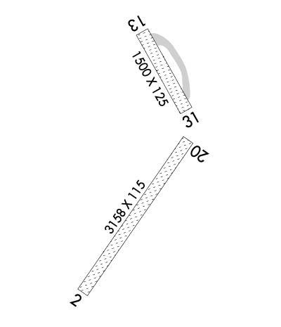
Runway Identifications
Runway Identification: 02/20Length: 3158 ft
Width: 115 ft
Surface: -GOOD CONDITION
Edge lights: Treatment: NONE
| | Runway: 02 | | Runway: 20 |
| Mag heading: | 16° | Mag heading: | 196° |
| Rwy Slope: | .01% Up | Rwy Slope: | -.01% Down |
| Approach: | | Approach: | |
| Pattern: | Left Traffic | Pattern: | Left Traffic |
| Markings: | | Markings: | |
| Marking Condition: | POOR; RWY 02/20 MARKED WITH RWY CONES. | Marking Condition: | POOR |
| Arresting Dev: | | Arresting Dev: | |
| Lat & Long: | N5926.7 W14618.8 | Lat. & Long.: | N5927.1 W14618.2 |
| Elev: | 100.1 ft. MSL | Elev: | 100.4 ft. MSL |
| TCH: | | TCH: | |
| Visual Glide Path: | | Visual Glide Path: | |
| Displaced Threshold: | No | Displaced Threshold: | No |
| Touchdown Zone: | YES | Touchdown Zone: | YES |
| Touchdown Elev.: | 100.3 feet | Touchdown Elev.: | 100.4 feet |
| Visual Glide Slope: | | Visual Glide Slope: | |
| RVR Equipment: | | RVR Equipment: | |
| RVV Equipment: | NO | RVV Equipment: | NO |
| Approach Lights: | | Approach Lights: | |
| REIL: | NO | REIL: | NO |
| Centerline Lights: | NO | Centerline Lights: | NO |
| Touchdown lights: | NO | Touchdown lights: | NO |
| Runway Category: | | Runway Category: | |
| Declared Distances: | | Declared Distances: | |
| Obstructions: | ROAD | Obstructions: | ROAD |
| Marked: | NOT Marked/Lighted | Marked: | NOT Marked/Lighted |
| Clearance slope: | | Clearance slope: | |
| Obstruction height: | 15 feet AGL | Obstruction height: | 15 feet AGL |
| Dist. from runway: | 0 feet | Dist. from runway: | 0 feet |
| Centerline offset: | 94 left of centerline | Centerline offset: | 84 feet right of centerline |
| Comments: | | Comments: | |
Runway Identification: 13/31Length: 1500 ft
Width: 125 ft
Surface: GRASS NATURAL SOIL
Edge lights: Treatment: NONE
| | Runway: 13 | | Runway: 31 |
| Mag heading: | 131° | Mag heading: | 311° |
| Rwy Slope: | -.14% Down | Rwy Slope: | .14% Up |
| Approach: | | Approach: | |
| Pattern: | Left Traffic | Pattern: | Left Traffic |
| Markings: | | Markings: | |
| Marking Condition: | 13/31 MKD WITH CONES & OTS LIGHTS. MANY MISSING. | Marking Condition: | |
| Arresting Dev: | | Arresting Dev: | |
| Lat & Long: | N5927.4 W14618.5 | Lat. & Long.: | N5927.2 W14618.2 |
| Elev: | 98.9 ft. MSL | Elev: | 96.8 ft. MSL |
| TCH: | | TCH: | |
| Visual Glide Path: | | Visual Glide Path: | |
| Displaced Threshold: | No | Displaced Threshold: | No |
| Touchdown Zone: | YES | Touchdown Zone: | YES |
| Touchdown Elev.: | 98.9 feet | Touchdown Elev.: | 98.9 feet |
| Visual Glide Slope: | | Visual Glide Slope: | |
| RVR Equipment: | | RVR Equipment: | |
| RVV Equipment: | NO | RVV Equipment: | NO |
| Approach Lights: | | Approach Lights: | |
| REIL: | NO | REIL: | NO |
| Centerline Lights: | NO | Centerline Lights: | NO |
| Touchdown lights: | NO | Touchdown lights: | NO |
| Runway Category: | | Runway Category: | |
| Declared Distances: | | Declared Distances: | |
| Obstructions: | ROAD | Obstructions: | ROAD |
| Marked: | NOT Marked/Lighted | Marked: | NOT Marked/Lighted |
| Clearance slope: | | Clearance slope: | |
| Obstruction height: | 15 feet AGL | Obstruction height: | 15 feet AGL |
| Dist. from runway: | 0 feet | Dist. from runway: | 0 feet |
| Centerline offset: | 74 right of centerline | Centerline offset: | 90 feet left of centerline |
| Comments: | | Comments: | |

