Click here for more info on on SMS!

PALH

LAKE HOOD SEAPLANE BASE
ANCHORAGE
AK
Time Zone: Alaska
Lat: N 6111.2
Long: W 14957.9
Elev: 79
Var: -25
Longest Runway: 2200
Clr Del: 119.4
Dept. ATIS: 125.6
Arr. ATIS: 125.6
Tower: 126.8

FBO & Flight Services info for PALH

FBOs: Update your Fuel Prices

CROWLEY FUELSPh: 907-266-2741
-
-
Service
Jet
100LL
SAF
MoGas
Fuel Avail: 24/7 self-serve
Full        Caution: Fuel prices have not been updated in 60 days.
Last Update: 02/26/2024 15:21

Self  6.70    
 Address: 3750 FLOATPLANE DR, 2321 MERRILL FIELD DR   ANCHORAGE, AK 99519
ASOSPh: 907-245-1618
-
-
 
If you are an FBO, call 1-203-262-1700 to update your info or email: FltPlan.Advertising@garmin.com
Advertise your FBO on FltPlan.com

Runway & Approach Info for PALH
Rwy
Length
Land Dist**
Approach*
  Rwy
Length
Land Dist**
Approach*
14
2200x75  2200'          
 
  
32
  2200x75  2200'          
 
E
4541x188  4541'          
 
  
W
  4541x188  4541'          
 
N
1930x200  1930'          
 
  
S
  1930x200  1930'          
 
NW
1369x150  1369'          
 
  
SE
  1369x150  1369'          
 
 * only ILS, LOC, LDA, and SDF approaches to a specific runway are shown
** For any Declared Landing Distance Available, please see A/FD or Approach plates
Runway Weight Capability (lbs.) Help
Runway IDSingle WheelDouble WheelDouble Tandem WheelDual Double Wheel
14/32N/AN/AN/AN/A
E/WN/AN/AN/AN/A
N/SN/AN/AN/AN/A
SE/NWN/AN/AN/AN/A
These numbers are Advisory and are not limits.   The Airport Manager should have more accurate Weight Limits
Approach Charts
Approaches    
Current Weather/Notams
Customs Information Send updates to Support@FltPlan.com
Customs Not Available
Database effective 05/16/2024
Airport Diagram of PALH
Airport Diagram might not be current.

Facility Name: LAKE HOOD
City Name: ANCHORAGE
County: ANCHORAGE
State abbrev: AK
State Name: ALASKA
   
Ownership: PUBLICLY OWNED
Use: OPEN TO THE PUBLIC
Owner's Name: STATE OF AK - DOT & PF
Address: PO BOX 196960
 ANCHORAGE, AK 99519-6960
Owner's Phone: 907-266-2741
  
Manager's Name: TIM COONS
Address: STATE OF AK - DOT & PF, PO BOX 196960
 ANCHORAGE, AK 99519-6960
Phone: 907-266-2741
   
FAA Region: ALASKA
FAA Field Office: NONE


Sunrise / Sunset times for LAKE HOOD

DateSunriseSunset
04/25/24 Thursday6:0621:51
04/26/24 Friday6:0321:54
04/27/24 Saturday6:0021:56
04/28/24 Sunday5:5721:59
04/29/24 Monday5:5422:02
04/30/24 Tuesday5:5122:04
05/01/24 Wednesday5:4822:07
05/02/24 Thursday5:4522:10
05/03/24 Friday5:4222:12
05/04/24 Saturday5:4022:15
05/05/24 Sunday5:3722:18
05/06/24 Monday5:3422:20
05/07/24 Tuesday5:3122:23
05/08/24 Wednesday5:2922:25

Airport Facilities

Airport Attendance ScheduleCONTINUOUS
Airport Status OPERATIONAL (This Status can change at any time - please check NOTAMS)
Airport Lighting ScheduleSS-SR
Airport Storage AvailableTie Downs, Hanger
Extra Services AvailableAir Freight, Avionics, Beaching Gear, Cargo Handling, Charter, Flight Instruction
Wind IndicatorYES - (unlit)
Control TowerYES
CTAF Frequency126.800
Unicom Frequency
Rotating Beacon Color
Segmented CircleNO
Landing FeeNO

Airport Inspection Data

Airport InspectedSTATE - performed by STATE AERONAUTICAL PERSONNEL
Inspection Date08/23/2022

Airport Services

Type of Fuel AvailableGrade 100, Grade 100LL, JET A (freeze point -40C); -10AVBL AT RWY 14/32 TSNT PRKG & FBOS.
Airframe Repair ServiceMAJOR
Power Plant Repair ServiceMAJOR

Geographic Data

LatitudeN6111.2
LongitudeW14957.9 (ESTIMATED)
Arpt Elevation79ft (SURVEYED)
Magnetic Variation25E
3 miles SWof ANCHORAGE
Traffic Pattern Altitude600
Sectional ChartANCHORAGE

Aircraft Data

Operations (Reported)YearlyAvg. Daily
General Aviation Transient 44000121
General Aviation Local 1000027
Air Taxi 1800049
Commerical 1000
Commuter 00
Military 100
Aircraft based on Field
General Aviation Singles 999; TOTAL: 1185.
General Aviation Multi 33
Jet Aircraft 0
General Aviation Helicopters 0
Military Aircraft 0
Gliders 0
Ultralights 0

FAA Services

FSS on field NO
FSS tie-in KENAI
FSS Phone 1-800-866-864-1737
Who issues Notams LHD
Notam D service at airport YES
ARTCC Name ANCHORAGE

Federal Status

Airport Certification
Aircraft Rescue & Firefighting IndexNone
Airport of EntryNo
Custom Landing RightsNo
Joint Civil/MilitaryNo
Military Landing rightsYES

Federal Agreements

NATIONAL PLAN OF INTEGRATED AIRPORT SYSTEMS (NPIAS)
GRANT AGREEMENTS UNDER FAAP/ADAP/AIP
ASSURANCES PURSUANT TO TITLE VI, CIVIL RIGHTS ACT OF 1964

Remarks

PUB RAMPS ON N & W SHORE OF LAKE HOOD.
ANCHORAGE WX CAMERA AVBL ON INTERNET AT HTTPS://WEATHERCAMS.FAA.GOV
NOISE SENSITIVE AREA IN EFFECT; CTC AMGR 907-266-2741 FOR FURTHER INFO.
TWY V PCL SECURITY GATE EAST OF TWY E; KEY 121.75 5 TIMES TO ACTVT.
FLOATING DEBRIS ON LAKE.
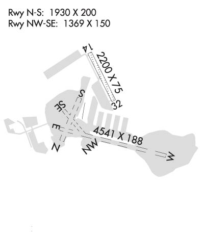
SEE NOTICE IN SECTION C FOR AIRPORT LAYOUT GRAPHIC.
TWY AROUND LAKE HOOD IS A JOINT USE TWY/ROAD & IS USED BY MOTOR VEHICLES/BICYCLISTS/JOGGERS AND TOUR BUSES. USE OF LANDING LIGHT WHEN TAXIING RCMDD.
TWY H-2/LAKESHORE TWY GATES PCL; KEY 121.75 3 TIMES TO ACTVT.
PPR FOR NON-RADIO OPNS. CTC FAA AT 907-271-5936. REQUEST TO BE TRANSFERRED TO ATCT. PROVIDE AN ETA AND REMAIN WITHIN PLUS/MINUS 15 MIN. NO NIGHTIME NON-RADIO ACFT OPNS.
RY 14/32 TFC PATTERNS OVERLAP SEADROME PATTERNS.
LAKE CLSD TO ACFT OVER 12500 LBS FM FREEZUP TIL APRXLY DEC 31; OVERFLOWS INTO ICE MAY OCCUR WINTER MONTHS.
AREA NW & SW OF LAKE SPENARD FM CANAL EASTWARD 1500' NOT VSBL FM ATCT.
NUMEROUS WATERFOWL AND NESTING AREAS INVOF ARPT.
FOR AVBLTY OF WINTER SKI OPNS ON LAKE SURFACES, CONSULT LOCAL NOTAMS AND CTC TWR PRIOR TO ARR /DEP.
NORTH POTHOLE DESIGNATED NO-WAKE AREA TO PROTECT MOORED AIRCRAFT/SHORELINE
ALL WATERLANES ELEV 76 FT TO LAKE HOOD SEAPLANE BASE (LHD).
ARRIVAL/DEPARTURE ROUTES; SEE AREA NOTICES.
LARGE FLOCKS OF MIGRATORY BIRDS INVOF ARPT SPRING TO FALL.
RWY 14/3 2 LTD TO 9000 LB OR LESS.
Airport Communications & Frequencies:
ATIS Frequencies:   Hours(local) of Operation: 24 HRS
125.6
LAKE HOOD Tower Frequencies:   Hours(local) of operation: CONTINUOUS   
126.8
Clearance Delivery Frequencies:
119.4
CTAF Frequency:
126.800
Remarks
  • 907-245-5432
  • ANCHORAGE Primary Approach Frequencies:  
    119.1
    363.2
    ANCHORAGE Primary Departure Frequencies:  
    119.1
    363.2
    Class C Frequencies:
    119.1
    363.2
    Runway Identifications
    Runway Identification: 14/32
    Length: 2200 ft
    Width: 75 ft
    Surface: NATURAL SOIL-GOOD CONDITION
    Edge lights: Medium Intensity

    Treatment: NONE

     Runway: 14   Runway: 32
    Mag heading: 128°Mag heading: 308°
    Rwy Slope: .21% UpRwy Slope: -.21% Down
    Approach: Approach:
    Pattern: Left TrafficPattern: Right Traffic
    Markings: Markings:
    Marking Condition: Marking Condition:
    Arresting Dev: Arresting Dev:
    Lat & Long: N6111.4  W14958.1Lat. & Long.: N6111.0  W14957.8
    Elev: 74.6 ft. MSLElev: 79.3 ft. MSL
    TCH: TCH:
    Visual Glide Path: Visual Glide Path:
    Displaced Threshold: NoDisplaced Threshold: No
    Touchdown Zone: YESTouchdown Zone: YES
    Touchdown Elev.: 79.3 feetTouchdown Elev.: 79.3 feet
    Visual Glide Slope: Visual Glide Slope:
    RVR Equipment: RVR Equipment:
    RVV Equipment: NORVV Equipment: NO
    Approach Lights: Approach Lights:
    REIL: NOREIL: NO
    Centerline Lights: NOCenterline Lights: NO
    Touchdown lights: NOTouchdown lights: NO
    Runway Category: Runway with a Visual ApproachRunway Category: Runway with a Visual Approach
    Declared Distances: Declared Distances:
    Obstructions: TREEObstructions: TREE
    Marked: NOT Marked/LightedMarked: NOT Marked/Lighted
    Clearance slope: 13:1Clearance slope: 15:1
    Obstruction height: 68 feet AGLObstruction height: 40 feet AGL
    Dist. from runway: 936 feetDist. from runway: 633 feet
    Centerline offset: 285 left of centerlineCenterline offset: 109 feet left of centerline
    Comments: Comments:
    Runway Identification: E/W
    Length: 4541 ft
    Width: 188 ft
    Surface: WATER
    Edge lights:

    Treatment: NONE

     Runway: E   Runway: W
    Mag heading: N/AMag heading: N/A
    Approach: Approach:
    Pattern: Left TrafficPattern: Left Traffic
    Markings: Markings:
    Marking Condition: Marking Condition:
    Arresting Dev: Arresting Dev:
    Lat & Long:   Lat. & Long.:   
    Elev: N/AElev: N/A
    TCH: TCH:
    Visual Glide Path: Visual Glide Path:
    Displaced Threshold: NoDisplaced Threshold: No
    Touchdown Zone: NOTouchdown Zone: NO
    Touchdown Elev.: Touchdown Elev.:
    Visual Glide Slope: Visual Glide Slope:
    RVR Equipment: RVR Equipment:
    RVV Equipment: NORVV Equipment: NO
    Approach Lights: Approach Lights:
    REIL: NOREIL: NO
    Centerline Lights: NOCenterline Lights: NO
    Touchdown lights: NOTouchdown lights: NO
    Runway Category: Runway Category:
    Declared Distances: Declared Distances:
    Runway Identification: N/S
    Length: 1930 ft
    Width: 200 ft
    Surface: WATER
    Edge lights:

    Treatment: NONE

     Runway: N   Runway: S
    Mag heading: N/AMag heading: N/A
    Approach: Approach:
    Pattern: Left TrafficPattern: Left Traffic
    Markings: Markings:
    Marking Condition: Marking Condition:
    Arresting Dev: Arresting Dev:
    Lat & Long:   Lat. & Long.:   
    Elev: N/AElev: N/A
    TCH: TCH:
    Visual Glide Path: Visual Glide Path:
    Displaced Threshold: NoDisplaced Threshold: No
    Touchdown Zone: NOTouchdown Zone: NO
    Touchdown Elev.: Touchdown Elev.:
    Visual Glide Slope: Visual Glide Slope:
    RVR Equipment: RVR Equipment:
    RVV Equipment: NORVV Equipment: NO
    Approach Lights: Approach Lights:
    REIL: NOREIL: NO
    Centerline Lights: NOCenterline Lights: NO
    Touchdown lights: NOTouchdown lights: NO
    Runway Category: Runway Category:
    Declared Distances: Declared Distances:
    Runway Identification: SE/NW
    Length: 1369 ft
    Width: 150 ft
    Surface: WATER
    Edge lights:

    Treatment: NONE

     Runway: NW   Runway: SE
    Mag heading: N/AMag heading: N/A
    Approach: Approach:
    Pattern: Left TrafficPattern: Left Traffic
    Markings: Markings:
    Marking Condition: Marking Condition:
    Arresting Dev: Arresting Dev:
    Lat & Long:   Lat. & Long.:   
    Elev: N/AElev: N/A
    TCH: TCH:
    Visual Glide Path: Visual Glide Path:
    Displaced Threshold: NoDisplaced Threshold: No
    Touchdown Zone: NOTouchdown Zone: NO
    Touchdown Elev.: Touchdown Elev.:
    Visual Glide Slope: Visual Glide Slope:
    RVR Equipment: RVR Equipment:
    RVV Equipment: NORVV Equipment: NO
    Approach Lights: Approach Lights:
    REIL: NOREIL: NO
    Centerline Lights: NOCenterline Lights: NO
    Touchdown lights: NOTouchdown lights: NO
    Runway Category: Runway Category:
    Declared Distances: Declared Distances:
    C:/P: