
| ||||||||||||||||||||||||||||||||
| ||||||||||||||||||||||||||||||||
| ||||||||||||||||||||||||||||||||
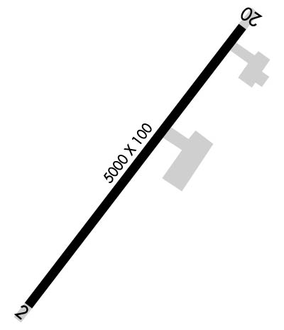
| Rwy | Rwy | |||||||
| 5000x100 | 5000' | 5000x100 | 5000' | |||||
| Runway ID | Single Wheel | Double Wheel | Double Tandem Wheel | Dual Double Wheel |
| 02/20 | N/A | 100,000 | N/A | N/A |
| These numbers are Advisory and are not limits. The Airport Manager should have more accurate Weight Limits | ||||
 Airport Diagram might not be current. | |
| Facility Name: | KLAWOCK |
| City Name: | KLAWOCK |
| County: | PRINCE OF WALES |
| State abbrev: | AK |
| State Name: | ALASKA |
| Ownership: | PUBLICLY OWNED |
| Use: | OPEN TO THE PUBLIC |
| Owner's Name: | ALASKA DOT&PF SOUTHCOAST REGION |
| Address: | P.O. BOX 112506 |
| JUNEAU, AK 99811-2506 | |
| Owner's Phone: | (907) 755-2229 |
| Manager's Name: | DOUG CARL |
| Address: | PO BOX 91, ALASKA DOT&PF |
| CRAIG, AK 99921-0091 | |
| Phone: | 907-755-2229 |
| FAA Region: | ALASKA |
| FAA Field Office: | NONE |
| Date | Sunrise | Sunset |
|---|---|---|
| 04/17/24 Wednesday | 5:40 | 20:04 |
| 04/18/24 Thursday | 5:38 | 20:06 |
| 04/19/24 Friday | 5:36 | 20:08 |
| 04/20/24 Saturday | 5:33 | 20:10 |
| 04/21/24 Sunday | 5:31 | 20:12 |
| 04/22/24 Monday | 5:28 | 20:14 |
| 04/23/24 Tuesday | 5:26 | 20:16 |
| 04/24/24 Wednesday | 5:24 | 20:18 |
| 04/25/24 Thursday | 5:21 | 20:20 |
| 04/26/24 Friday | 5:19 | 20:22 |
| 04/27/24 Saturday | 5:17 | 20:24 |
| 04/28/24 Sunday | 5:14 | 20:26 |
| 04/29/24 Monday | 5:12 | 20:28 |
| 04/30/24 Tuesday | 5:10 | 20:30 |
| Airport Attendance Schedule | UNATTENDED |
| Airport Status | OPERATIONAL (This Status can change at any time - please check NOTAMS) |
| Airport Lighting Schedule | ACTVT PAPI RWY 02 & 20; MIRL RWY 02/20; WINDSOCK; APRON LGTS - 122.25.; ACTVT ROTG BCN - CTAF. |
| Airport Storage Available | Tie Downs |
| Extra Services Available | Charter |
| Wind Indicator | YES - (lighted) |
| Control Tower | NO |
| CTAF Frequency | 120.900 |
| Unicom Frequency | |
| Rotating Beacon Color | WG |
| Segmented Circle | YES |
| Landing Fee | NO |
| Airport Inspected | STATE - performed by PRIVATE CONTRACT PERSONNEL |
| Inspection Date | 10/12/2023 |
| Type of Fuel Available | None |
| Airframe Repair Service | None |
| Power Plant Repair Service | None |
| Latitude | N5534.8 |
| Longitude | W13304.6 (ESTIMATED) |
| Arpt Elevation | 79ft (SURVEYED) |
| Magnetic Variation | 20E |
| 2 miles NE | of KLAWOCK |
| Traffic Pattern Altitude | |
| Sectional Chart | KETCHIKAN |
| Operations (Reported) | Yearly | Avg. Daily |
|---|---|---|
| General Aviation Transient | 700 | 2 |
| General Aviation Local | 200 | 1 |
| Air Taxi | 3300 | 9 |
| Commerical | 0 | 0 |
| Commuter | 0 | 0 |
| Military | 0 | 0 |
| Aircraft based on Field | |
|---|---|
| General Aviation Singles | 7 |
| General Aviation Multi | 0 |
| Jet Aircraft | 0 |
| General Aviation Helicopters | 0 |
| Military Aircraft | 0 |
| Gliders | 0 |
| Ultralights | 0 |
| FSS on field | NO |
| FSS tie-in | KETCHIKAN |
| FSS Phone | 225-9481 (Local call) |
| Nearby FSS | JUNEAU |
| Phone | 1-800-866-297-2236 |
| Who issues Notams | AKW |
| Notam D service at airport | YES |
| ARTCC Name | ANCHORAGE |
| Airport Certification | |
| Aircraft Rescue & Firefighting Index | None |
| Airport of Entry | No |
| Custom Landing Rights | No |
| Joint Civil/Military | No |
| Military Landing rights | YES |
| NATIONAL PLAN OF INTEGRATED AIRPORT SYSTEMS (NPIAS) |
| GRANT AGREEMENTS UNDER FAAP/ADAP/AIP |
| ASSURANCES PURSUANT TO TITLE VI, CIVIL RIGHTS ACT OF 1964 |
| BIRDS & WILDLIFE ON & INVOF ARPT. RPT BIRD ACT TO AMGR OR FSS. |
| RCMD DALGT OPS ONLY. |
| IREG WIND CONDS. |
| CLSD TO ACFT OVR 12500 LBS GTW EXC PPR - AMGR. |
| WX CAMERAS AVBL ON INTERNET AT HTTPS://WEATHERCAMS.FAA.GOV |
| COLD TEMPERATURE AIRPORT. ALTITUDE CORRECTION REQUIRED AT OR BELOW -10C. |
| HIGH TRRN ALL QUADS. |
| COND UNMNT; MAINT IREG; RCMD VISUAL INSP BFR USE. |
| PAJA ON RWY, TWY & PRKG APRON NA. |
| CLSD TO ACR OPS MORE THAN 30 PAX SEATS. |
| RWY 02/2 0 SLOPES DOWN 55-65 FT FM THRS TO CNTR. EXP DOWNDRAFT & TURB INVOF RWY 02 TDZ. |
| RWY 20 700 FT HILL 2 MI NE OF THR. |
Airport Communications & Frequencies:
| |||||||
| Runway: 02 | Runway: 20 | ||
| Mag heading: | 19° | Mag heading: | 199° |
| Rwy Slope: | .82% Up | Rwy Slope: | -.82% Down |
| Approach: | Approach: | ||
| Pattern: | Left Traffic | Pattern: | Right Traffic |
| Markings: | NONPRECISION INSTRUMENT | Markings: | NONPRECISION INSTRUMENT |
| Marking Condition: | FAIR; FADED. | Marking Condition: | FAIR; FADED. |
| Arresting Dev: | Arresting Dev: | ||
| Lat & Long: | N5534.4 W13305.0 | Lat. & Long.: | N5535.1 W13304.1 |
| Elev: | 38.7 ft. MSL | Elev: | 79.7 ft. MSL |
| TCH: | 34 ft. AGL | TCH: | 40 ft. AGL |
| Visual Glide Path: | 3.00 degrees | Visual Glide Path: | 4.00 degrees |
| Displaced Threshold: | No | Displaced Threshold: | No |
| Touchdown Zone: | YES | Touchdown Zone: | YES |
| Touchdown Elev.: | 56.7 feet | Touchdown Elev.: | 79.7 feet |
| Visual Glide Slope: | 4-Light PAPI on LEFT side of Runway | Visual Glide Slope: | 4-Light PAPI on LEFT side of Runway; RWY 20 PAPI UNUSBL BYD 3 DEGS LEFT OF CNTRLN. |
| RVR Equipment: | RVR Equipment: | ||
| RVV Equipment: | NO | RVV Equipment: | NO |
| Approach Lights: | Approach Lights: | ||
| REIL: | YES | REIL: | YES |
| Centerline Lights: | NO | Centerline Lights: | NO |
| Touchdown lights: | NO | Touchdown lights: | NO |
| Runway Category: | Runway with a Non-precision Approach | Runway Category: | Runway with a Visual Approach |
| Declared Distances: | Declared Distances: | ||
| Obstructions: | ROAD | Obstructions: | ROAD |
| Marked: | NOT Marked/Lighted | Marked: | NOT Marked/Lighted |
| Clearance slope: | Clearance slope: | ||
| Obstruction height: | 15 feet AGL | Obstruction height: | 15 feet AGL |
| Dist. from runway: | 201 feet | Dist. from runway: | 201 feet |
| Centerline offset: | 60 right of centerline | Centerline offset: | 60 feet left of centerline |
| Comments: | APCH SLOPE 0:1. ROAD BOTH SIDES OF RWY 0-200 FT FM THR. | Comments: | APCH SLOPE 0:1. ROAD ON L SIDE OF RWY 0-200 FT FM THR. |