Click here for more info on on SMS!

PAKL

KULIK LAKE AIRPORT
KULIK LAKE
AK
Time Zone: Alaska
Lat: N 5857.9
Long: W 15505.7
Elev: 717
Var: -15
Longest Runway: 4400
CTAF: 122.9

FBO & Flight Services info for PAKL

FBOs: Update your Fuel Prices

AIRPORTPh: 907-246-3305
-
Freq: 122.9
Service
Jet
100LL
SAF
MoGas
Fuel Avail: NO FUEL AVAILABLE
Full        Last Update: 04/24/2024 06:02:17

Self        
RUNWAY - GRAVEL
-
-
 
If you are an FBO, call 1-203-262-1700 to update your info or email: FltPlan.Advertising@garmin.com
Advertise your FBO on FltPlan.com

Runway & Approach Info for PAKL
Rwy
Length
Land Dist**
Approach*
  Rwy
Length
Land Dist**
Approach*
07
4400x110  4400'          
 
  
25
  4400x110  4400'          
 
18W
5000x5000  5000'          
 
  
36W
  5000x5000  5000'          
 
 * only ILS, LOC, LDA, and SDF approaches to a specific runway are shown
** For any Declared Landing Distance Available, please see A/FD or Approach plates
Runway Weight Capability (lbs.) Help
Runway IDSingle WheelDouble WheelDouble Tandem WheelDual Double Wheel
07/25N/AN/AN/AN/A
18W/36WN/AN/AN/AN/A
These numbers are Advisory and are not limits.   The Airport Manager should have more accurate Weight Limits
Approach Charts
FltPlan does not have IFR approach charts available for PAKL.
Current Weather/Notams
Customs Information Send updates to Support@FltPlan.com
Customs Not Available
Database effective 05/16/2024
Airport Diagram of PAKL
Airport Diagram might not be current.

Facility Name: KULIK LAKE
City Name: KULIK LAKE
County: BRISTOL BAY
State abbrev: AK
State Name: ALASKA
   
Ownership: PUBLICLY OWNED
Use: OPEN TO THE PUBLIC
Owner's Name: NPS KATMAI NATL PARK
Address: P.O. BOX 7
 KING SALMON, AK 99613
Owner's Phone: 907-246-3305
  
Manager's Name: PUBLIC PARK SUPT.
Address: P.O. BOX 7
 KING SALMON, AK 99613
Phone: 907-246-3305
   
FAA Region: ALASKA
FAA Field Office: NONE


Sunrise / Sunset times for KULIK LAKE

DateSunriseSunset
04/24/24 Wednesday6:3921:59
04/25/24 Thursday6:3622:01
04/26/24 Friday6:3422:04
04/27/24 Saturday6:3122:06
04/28/24 Sunday6:2822:08
04/29/24 Monday6:2622:11
04/30/24 Tuesday6:2322:13
05/01/24 Wednesday6:2122:15
05/02/24 Thursday6:1822:18
05/03/24 Friday6:1622:20
05/04/24 Saturday6:1322:22
05/05/24 Sunday6:1122:25
05/06/24 Monday6:0822:27
05/07/24 Tuesday6:0622:29

Airport Facilities

Airport Attendance ScheduleUNATTENDED
Airport Status OPERATIONAL (This Status can change at any time - please check NOTAMS)
Airport Lighting Schedule
Airport Storage AvailableNONE
Extra Services AvailableCargo Handling
Wind IndicatorNONE
Control TowerNO
CTAF Frequency122.900
Unicom Frequency
Rotating Beacon Color
Segmented CircleNO
Landing FeeYES

Airport Inspection Data

Airport InspectedSTATE - performed by PRIVATE CONTRACT PERSONNEL
Inspection Date05/24/2021

Airport Services

Type of Fuel AvailableNone
Airframe Repair ServiceNONE
Power Plant Repair ServiceNONE

Geographic Data

LatitudeN5857.9
LongitudeW15505.7 (ESTIMATED)
Arpt Elevation717ft (ESTIMATED)
Magnetic Variation15E
1 miles Sof KULIK LAKE
Traffic Pattern Altitude
Sectional ChartKODIAK

Aircraft Data

Operations (Reported)YearlyAvg. Daily
General Aviation Transient 00
General Aviation Local 1000
Air Taxi 1000
Commerical 00
Commuter 00
Military 00
Aircraft based on Field
General Aviation Singles 2
General Aviation Multi 1
Jet Aircraft 0
General Aviation Helicopters 0
Military Aircraft 0
Gliders 0
Ultralights 0

FAA Services

FSS on field NO
FSS tie-in ILIAMNA
FSS Phone 571-1240 (Local call)
Nearby FSS KENAI
Phone 1-800-866-864-1737
Who issues Notams ILI
Notam D service at airport YES
ARTCC Name ANCHORAGE

Federal Status

Airport Certification
Aircraft Rescue & Firefighting IndexNone
Airport of EntryNo
Custom Landing RightsNo
Joint Civil/MilitaryNo
Military Landing rightsNo

Remarks

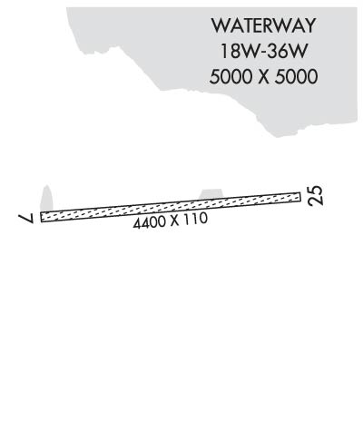
RY 18W/36W ACTIVE SUMMER FISHING SEASON ONLY - PUBLIC USE.
USE EXTREME CTN IN HIGH & GUSTY WIND.
RAMP ON W END OF RY PRIVATELY OWNED. YELLOW BARRELS MARK PROPERTY LINE.
EAST 2000 FEET OF RY ON NATL PARK LAND & OPEN TO THE PUBLIC; WEST 2600 FEET OF RY ON PVT LAND & CLSD TO THE PUBLIC - CTC RAYMOND PETERSON-4700 AIRCRAFT DR; ANCHORAGE AK 99502 OR CALL 907-243-5448.
HVY BEAR CONCENTRATION; BEARS FREQUENTLY ON RY DURING SUMMER.
SEAPLANE BASE IS PVT PROPERTY, NO SVCS OR FACS AVBL.
RWY 07/2 5 SFC COVERED UNIFORMLY WITH LOOSE 2 TO 5 INCH STONES.
Airport Communications & Frequencies:
CTAF Frequency:
122.900
Remarks
  • APCH/DEP SVC PRVDD BY ANCHORAGE ARTCC ON FREQ 124.8 (KING SALMON RCAG).
  • Runway Identifications
    Runway Identification: 07/25
    Length: 4400 ft
    Width: 110 ft
    Surface: NATURAL SOIL-FAIR CONDITION
    Edge lights:

    Treatment: NONE

     Runway: 07   Runway: 25
    Mag heading: 71°Mag heading: 251°
    Rwy Slope: .34% UpRwy Slope: -.34% Down
    Approach: Approach:
    Pattern: Left TrafficPattern: Left Traffic
    Markings: Markings:
    Marking Condition: Marking Condition:
    Arresting Dev: Arresting Dev:
    Lat & Long: N5857.9  W15506.4Lat. & Long.: N5857.9  W15505.0
    Elev: 700.0 ft. MSLElev: 715.0 ft. MSL
    TCH: TCH:
    Visual Glide Path: Visual Glide Path:
    Displaced Threshold: NoDisplaced Threshold: No
    Touchdown Zone: YESTouchdown Zone: NO
    Touchdown Elev.: 717.0 feetTouchdown Elev.:
    Visual Glide Slope: Visual Glide Slope:
    RVR Equipment: RVR Equipment:
    RVV Equipment: NORVV Equipment: NO
    Approach Lights: Approach Lights:
    REIL: NOREIL: NO
    Centerline Lights: NOCenterline Lights: NO
    Touchdown lights: NOTouchdown lights: NO
    Runway Category: Runway with a Visual ApproachRunway Category: Runway with a Visual Approach
    Declared Distances: Declared Distances:
    Obstructions: BRUSHObstructions: BRUSH
    Marked: NOT Marked/LightedMarked: NOT Marked/Lighted
    Clearance slope: Clearance slope:
    Obstruction height: 15 feet AGLObstruction height: 15 feet AGL
    Dist. from runway: 0 feetDist. from runway: 0 feet
    Centerline offset: BCenterline offset: B
    Comments: Comments:
    Runway Identification: 18W/36W
    Length: 5000 ft
    Width: 5000 ft
    Surface: WATER
    Edge lights:

    Treatment: NONE

     Runway: 18W   Runway: 36W
    Mag heading: N/AMag heading: N/A
    Rwy Slope: .00%Rwy Slope: .00%
    Approach: Approach:
    Pattern: Left TrafficPattern: Left Traffic
    Markings: Markings:
    Marking Condition: Marking Condition:
    Arresting Dev: Arresting Dev:
    Lat & Long:   Lat. & Long.:   
    Elev: 656.0 ft. MSLElev: 656.0 ft. MSL
    TCH: TCH:
    Visual Glide Path: Visual Glide Path:
    Displaced Threshold: NoDisplaced Threshold: No
    Touchdown Zone: NOTouchdown Zone: NO
    Touchdown Elev.: Touchdown Elev.:
    Visual Glide Slope: Visual Glide Slope:
    RVR Equipment: RVR Equipment:
    RVV Equipment: NORVV Equipment: NO
    Approach Lights: Approach Lights:
    REIL: NOREIL: NO
    Centerline Lights: NOCenterline Lights: NO
    Touchdown lights: NOTouchdown lights: NO
    Runway Category: Runway Category:
    Declared Distances: Declared Distances:
    C:/P: