
| ||||||||||||||||||||||||||||||||||||||||||||||||||||||||||||||||||||
| ||||||||||||||||||||||||||||||||||||||||||||||||||||||||||||||||||||
| ||||||||||||||||||||||||||||||||||||||||||||||||||||||||||||||||||||
| ||||||||||||||||||||||||||||||||||||||||||||||||||||||||||||||||||||
| ||||||||||||||||||||||||||||||||||||||||||||||||||||||||||||||||||||
| ||||||||||||||||||||||||||||||||||||||||||||||||||||||||||||||||||||
| Rwy | Rwy | |||||||
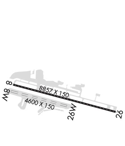
| 8857x150 | 8857' | 109.90 - 070° | 8857x150 | 8857' | ||||
| 4800x150 | 4800' | 4800x150 | 4800' | |||||
| Runway ID | Single Wheel | Double Wheel | Double Tandem Wheel | Dual Double Wheel |
| 08/26 | 120,000 | 250,000 | 550,000 | N/A |
| 08W/26W | N/A | N/A | N/A | N/A |
| These numbers are Advisory and are not limits. The Airport Manager should have more accurate Weight Limits | ||||
 Airport Diagram might not be current. | |
| Facility Name: | JUNEAU INTL |
| City Name: | JUNEAU |
| County: | JUNEAU |
| State abbrev: | AK |
| State Name: | ALASKA |
| Ownership: | PUBLICLY OWNED |
| Use: | OPEN TO THE PUBLIC |
| Owner's Name: | CITY OF JUNEAU |
| Address: | 155 S SEWARD |
| JUNEAU, AK 99801 | |
| Owner's Phone: | 907-789-7821 |
| Manager's Name: | PATTY WAHTO |
| Address: | 1873 SHELL SIMMONS DR, SUITE 200 |
| JUNEAU, AK 99801 | |
| Phone: | 907-789-7821 |
| FAA Region: | ALASKA |
| FAA Field Office: | NONE |
| Date | Sunrise | Sunset |
|---|---|---|
| 04/17/24 Wednesday | 5:38 | 20:18 |
| 04/18/24 Thursday | 5:36 | 20:21 |
| 04/19/24 Friday | 5:33 | 20:23 |
| 04/20/24 Saturday | 5:30 | 20:25 |
| 04/21/24 Sunday | 5:28 | 20:27 |
| 04/22/24 Monday | 5:25 | 20:30 |
| 04/23/24 Tuesday | 5:22 | 20:32 |
| 04/24/24 Wednesday | 5:20 | 20:34 |
| 04/25/24 Thursday | 5:17 | 20:36 |
| 04/26/24 Friday | 5:14 | 20:39 |
| 04/27/24 Saturday | 5:12 | 20:41 |
| 04/28/24 Sunday | 5:09 | 20:43 |
| 04/29/24 Monday | 5:07 | 20:46 |
| 04/30/24 Tuesday | 5:04 | 20:48 |
| Airport Attendance Schedule | CONTINUOUS |
| Airport Status | OPERATIONAL (This Status can change at any time - please check NOTAMS) |
| Airport Lighting Schedule | FOR HIRL RWY 08/26, MALSF RWY 08 & REIL RWY 26 CTC JNU ATCT ON FREQ 118.7. WHEN ATCT CLSD CTC JNU FSS ON FREQ 118.7. VASI RWY 08 & PAPI RWY 26 OPER 24 HRS. |
| Airport Storage Available | Tie Downs, Hanger, Buoys |
| Extra Services Available | Air Freight, Air Ambulance, Avionics, Cargo Handling, Charter, Flight Instruction |
| Wind Indicator | YES - (lighted) |
| Control Tower | YES |
| CTAF Frequency | 118.700 |
| Unicom Frequency | 122.950 |
| Rotating Beacon Color | WG |
| Segmented Circle | YES |
| Landing Fee | YES |
| Airport Inspected | FEDERAL - performed by FAA AIRPORTS FIELD PERSONNEL |
| Inspection Date | 11/30/2023 |
| Type of Fuel Available | Grade 100LL, JET A-1 (icing inhibitor, freeze point -50C); -10FUEL AVBL THRU ARPT SVCS ON UNICOM OR 907-789-0055 OR 907-789-5622. |
| Airframe Repair Service | MAJOR; AIRFRAME/POWER PLANT SVC FOR SINGLE/TWIN PROP ENG ACFT TURBIN & AVIONICS. |
| Power Plant Repair Service | MAJOR |
| Latitude | N5821.3 |
| Longitude | W13434.7 (ESTIMATED) |
| Arpt Elevation | 25ft (ESTIMATED) |
| Magnetic Variation | 20E |
| 7 miles NW | of JUNEAU |
| Traffic Pattern Altitude | |
| Sectional Chart | JUNEAU |
| Operations (Reported) | Yearly | Avg. Daily |
|---|---|---|
| General Aviation Transient | 7952 | 22 |
| General Aviation Local | 2330 | 6 |
| Air Taxi | 75127 | 206 |
| Commerical | 8854 | 24 |
| Commuter | 0 | 0 |
| Military | 322 | 1 |
| Aircraft based on Field | |
|---|---|
| General Aviation Singles | 239 |
| General Aviation Multi | 4 |
| Jet Aircraft | 1 |
| General Aviation Helicopters | 28 |
| Military Aircraft | 3 |
| Gliders | 0 |
| Ultralights | 0 |
| FSS on field | YES |
| FSS tie-in | JUNEAU; CTC JUNEAU FSS FOR AIRPORT ADVISORY SERVICE ON 118.7 WHEN TOWER IS CLSD. |
| FSS Phone | 1-800-866-297-2236 |
| Who issues Notams | JNU |
| Notam D service at airport | YES |
| ARTCC Name | ANCHORAGE |
| Airport Certification | AIRPORT RECEIVING SCHEDULED AIR CARRIER SERVICE FROM CARRIERS CERTIFICATED BY THE CIVIL AERONAUTICS BOARD |
| Aircraft Rescue & Firefighting Index | AIRPORT HAS A CERTIFICATE UNDER CFR PART 139 |
| Airport of Entry | YES |
| Custom Landing Rights | No |
| Joint Civil/Military | No |
| Military Landing rights | YES |
| NATIONAL PLAN OF INTEGRATED AIRPORT SYSTEMS (NPIAS) |
| GRANT AGREEMENTS UNDER FAAP/ADAP/AIP |
| SURPLUS PROPERTY AGREEMENT UNDER PUBLIC LAW 289 |
| CONVEYANCE UNDER SCETION 16, FEDERAL AIRPORT ACT OF 1946 OR SECTION 23, AIRPORT AND AIRWAY DEVELOPMENT ACT OF 1970 |
| ASSURANCES PURSUANT TO TITLE VI, CIVIL RIGHTS ACT OF 1964 |
| FOR LCL CALL TO JUNEAU FSS CALL 907-789-7380. |
| TRANSIENT DOCK AVBL FOR PUBLIC USE FOR UP TO SIX ACFT, SW CORNER. |
| SEE SPECIAL NOTICES AND GENERAL NOTICES FOR ADDITIONAL INFORMATION ON OPNS IN JUNEAU AREA. |
| LENA POINT, PEDERSON HILL AND SISTERS ISLAND WX CAMERAS AVBL ON INTERNET AT HTTPS://WEATHERCAMS.FAA.GOV |
| RY 08/26 SAND USED TO ENHANCE RY FRICTION MAY NOT MEET FAA SPECS. |
| COLD TEMPERATURE AIRPORT. ALTITUDE CORRECTION REQUIRED AT OR BELOW -0C. |
| APRON TERMINAL RAMP CLSD TO ROTORCRAFT. APRON US CUSTOMS RAMP CLSD TO ACFT WITH WINGSPAN MORE THAN 79 FT INTL ACFT WITH WINGSPAN MORE THAN 79 FT AND ALL INTL ROTORCRAFT USE E-1 RAMP (NTL GUARD RAMP). |
| NATIONAL GUARD 24 HR PPR DUE TO LIMITED PARKING C907-789-3366. 0730-1600 WEEKDAYS CONTACT GUARD OPS 10 MIN PRIOR TO LANDING ON 124.65. |
| WILDLIFE & BIRDS ON & INVOF ARPT. |
| BATTLESHIP ISLAND RLLS GROUPING; CENTER LIGHT 582132.88N 1344012.22W. IJDL-LOCALIZER RLLS GROUPING; CENTER LIGHT 582132.02N 1343810.39W. |
| INCREASED HELICOPTER/LIGH ACFT ACTIVITY APR 15-OCT 1 ENTIRE LENGTH ON GASTINEAU CHANNEL & WITHIN 5 MILES OF ARPT. |
| PARAGLIDING ACTIVITY 3 MILES N OF ARPT INVOF THUNDER MOUNTAIN & OVER GASTINEAU CHANNEL NEARS DOWNTOWN APR 15-OCT 1 6000 FT & BLO. |
| TPA 1500 AGL FOR LARGE TURBINE ACFT; 1000 FT AGL FOR FIXED WING ACFT; 500 FT AGL FOR HELICOPTERS. |
Airport Communications & Frequencies:
| |||||||||||||||||||||
| Runway: 08 | Runway: 26 | ||
| Mag heading: | 85° | Mag heading: | 265° |
| Rwy Slope: | -.02% Down | Rwy Slope: | .02% Up |
| Approach: | LDA/DME | Approach: | |
| Pattern: | Right Traffic | Pattern: | Left Traffic |
| Markings: | NONPRECISION INSTRUMENT | Markings: | NONPRECISION INSTRUMENT |
| Marking Condition: | FAIR | Marking Condition: | FAIR |
| Arresting Dev: | Arresting Dev: | ||
| Lat & Long: | N5821.5 W13435.8 | Lat. & Long.: | N5821.1 W13433.1 |
| Elev: | 25.0 ft. MSL | Elev: | 23.4 ft. MSL |
| TCH: | 38 ft. AGL | TCH: | 46 ft. AGL |
| Visual Glide Path: | 3.50 degrees | Visual Glide Path: | 3.50 degrees |
| Displaced Threshold: | No | Displaced Threshold: | No |
| Touchdown Zone: | YES | Touchdown Zone: | YES |
| Touchdown Elev.: | 25.0 feet | Touchdown Elev.: | 23.4 feet |
| Visual Glide Slope: | 2-Box VASI on LEFT side of Runway; VASI ALIGNED APRXLY 13 DEGS RIGHT OF RY CNTRLN AND IS NOT VISIBLE ON RY CNTRL. VASI UNUSBL BYD 06 DEGS LEFT OF CRS. | Visual Glide Slope: | 4-Light PAPI on LEFT side of Runway; RY 26 PAPI UNUSBL BYD 2 NM DUE TO TERRAIN. |
| RVR Equipment: | TOUCHDOWN-ROLLOUT | RVR Equipment: | TOUCHDOWN-ROLLOUT |
| RVV Equipment: | YES | RVV Equipment: | YES |
| Approach Lights: | MALSF - 1,400 foot medium intensity approach lighting system with sequenced flashers; RLLS LGTS: ( JNUB BATTLESHIP ISLAND, JNUA ENGINEERS CUT, JNU WETLANDS/FLATS) | Approach Lights: | MALS - 1,400 foot medium intensity approach lighting system; RY 26 MALS NSTD; LENGTH 800 FT. |
| REIL: | YES | REIL: | YES |
| Centerline Lights: | YES | Centerline Lights: | YES |
| Touchdown lights: | NO | Touchdown lights: | NO |
| Runway Category: | Runway with a Non-precision Approach having visibility minimums greater than 3/4 mile | Runway Category: | Runway with a Non-precision Approach having visibility minimums greater than 3/4 mile |
| Declared Distances: | TORA:8857' TODA:8857' ASDA:8457' LDA:8457' | Declared Distances: | TORA:8857' TODA:8857' ASDA:8457' LDA:8457' |
| Obstructions: | TOWER | Obstructions: | |
| Marked: | MARKED and LIGHTED | Marked: | |
| Clearance slope: | 12:1 | Clearance slope: | 34:1 |
| Obstruction height: | 573 feet AGL | Obstruction height: | |
| Dist. from runway: | 7600 feet | Dist. from runway: | |
| Centerline offset: | 900 left of centerline | Centerline offset: | |
| Comments: | Comments: |
| Runway: 08W | Runway: 26W | ||
| Mag heading: | N/A | Mag heading: | N/A |
| Approach: | Approach: | ||
| Pattern: | Left Traffic | Pattern: | Left Traffic |
| Markings: | Markings: | ||
| Marking Condition: | Marking Condition: | ||
| Arresting Dev: | Arresting Dev: | ||
| Lat & Long: | N5821.4 W13435.9 | Lat. & Long.: | N5821.2 W13434.4 |
| Elev: | N/A | Elev: | N/A |
| TCH: | TCH: | ||
| Visual Glide Path: | Visual Glide Path: | ||
| Displaced Threshold: | No | Displaced Threshold: | No |
| Touchdown Zone: | NO | Touchdown Zone: | NO |
| Touchdown Elev.: | Touchdown Elev.: | ||
| Visual Glide Slope: | Visual Glide Slope: | ||
| RVR Equipment: | RVR Equipment: | ||
| RVV Equipment: | NO | RVV Equipment: | NO |
| Approach Lights: | Approach Lights: | ||
| REIL: | NO | REIL: | NO |
| Centerline Lights: | NO | Centerline Lights: | NO |
| Touchdown lights: | NO | Touchdown lights: | NO |
| Runway Category: | Runway with a Visual Approach | Runway Category: | Runway with a Visual Approach |
| Declared Distances: | Declared Distances: |


