
| ||||||||||||||||||||||||||||||||
| ||||||||||||||||||||||||||||||||
| ||||||||||||||||||||||||||||||||
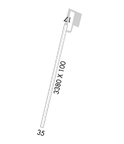
| Rwy | Rwy | |||||||
| 3381x100 | 3381' | 3381x100 | 3381' | |||||
| Runway ID | Single Wheel | Double Wheel | Double Tandem Wheel | Dual Double Wheel |
| 18/36 | N/A | N/A | N/A | N/A |
| These numbers are Advisory and are not limits. The Airport Manager should have more accurate Weight Limits | ||||
 Airport Diagram might not be current. | |
| Facility Name: | HUGHES |
| City Name: | HUGHES |
| County: | YUKON-KOYUKUK |
| State abbrev: | AK |
| State Name: | ALASKA |
| Ownership: | PUBLICLY OWNED |
| Use: | OPEN TO THE PUBLIC |
| Owner's Name: | ALASKA DOT&PF NORTHERN REGION |
| Address: | 2301 PEGER RD |
| FAIRBANKS, AK 99709 | |
| Owner's Phone: | (907) 451-5280 |
| Manager's Name: | JASON LUDINGTON |
| Address: | 2301 PEGER RD |
| FAIRBANKS, AK 99709 | |
| Phone: | (907) 451-5280 |
| FAA Region: | ALASKA |
| FAA Field Office: | NONE |
| Date | Sunrise | Sunset |
|---|---|---|
| 04/24/24 Wednesday | 5:57 | 22:35 |
| 04/25/24 Thursday | 5:53 | 22:38 |
| 04/26/24 Friday | 5:49 | 22:42 |
| 04/27/24 Saturday | 5:45 | 22:46 |
| 04/28/24 Sunday | 5:41 | 22:49 |
| 04/29/24 Monday | 5:37 | 22:53 |
| 04/30/24 Tuesday | 5:34 | 22:57 |
| 05/01/24 Wednesday | 5:30 | 23:00 |
| 05/02/24 Thursday | 5:26 | 23:04 |
| 05/03/24 Friday | 5:22 | 23:08 |
| 05/04/24 Saturday | 5:18 | 23:12 |
| 05/05/24 Sunday | 5:14 | 23:16 |
| 05/06/24 Monday | 5:10 | 23:19 |
| 05/07/24 Tuesday | 5:06 | 23:23 |
| Airport Attendance Schedule | UNATTENDED |
| Airport Status | OPERATIONAL (This Status can change at any time - please check NOTAMS) |
| Airport Lighting Schedule | ACTVT MIRL RWY 18/36 - CTAF.; ACTVT ROTATING BEACON - CTAF. |
| Airport Storage Available | NONE |
| Extra Services Available | NONE |
| Wind Indicator | YES - (lighted) |
| Control Tower | NO |
| CTAF Frequency | 122.900 |
| Unicom Frequency | |
| Rotating Beacon Color | WG |
| Segmented Circle | YES |
| Landing Fee | NO |
| Airport Inspected | CONTRACTOR - performed by PRIVATE CONTRACT PERSONNEL |
| Inspection Date | 07/22/2023 |
| Type of Fuel Available | None |
| Airframe Repair Service | NONE |
| Power Plant Repair Service | NONE |
| Latitude | N6602.3 |
| Longitude | W15415.9 (ESTIMATED) |
| Arpt Elevation | 298ft (SURVEYED) |
| Magnetic Variation | 13E |
| 1 miles SW | of HUGHES |
| Traffic Pattern Altitude | |
| Sectional Chart | FAIRBANKS |
| Operations (Reported) | Yearly | Avg. Daily |
|---|---|---|
| General Aviation Transient | 365 | 1 |
| General Aviation Local | 0 | 0 |
| Air Taxi | 1095 | 3 |
| Commerical | 0 | 0 |
| Commuter | 0 | 0 |
| Military | 20 | 0 |
| Aircraft based on Field | |
|---|---|
| General Aviation Singles | 0 |
| General Aviation Multi | 0 |
| Jet Aircraft | 0 |
| General Aviation Helicopters | 0 |
| Military Aircraft | 0 |
| Gliders | 0 |
| Ultralights | 0 |
| FSS on field | NO |
| FSS tie-in | FAIRBANKS |
| FSS Phone | 1-800-866-248-6516 |
| Who issues Notams | FAI |
| Notam D service at airport | YES |
| ARTCC Name | ANCHORAGE |
| Airport Certification | |
| Aircraft Rescue & Firefighting Index | None |
| Airport of Entry | No |
| Custom Landing Rights | No |
| Joint Civil/Military | No |
| Military Landing rights | No |
| NATIONAL PLAN OF INTEGRATED AIRPORT SYSTEMS (NPIAS) |
| CONVEYANCE UNDER SCETION 16, FEDERAL AIRPORT ACT OF 1946 OR SECTION 23, AIRPORT AND AIRWAY DEVELOPMENT ACT OF 1970 |
| GRANT AGREEMENT HAS EXPIRED; HOWEVER, AGREEMENT REMAINS IN EFFECT FOR THIS FACILITY AS LONG AS IT IS PUBLIC USE. |
| RWY CONDITION NOT MONITORED; RECOMMEND VISUAL INSPECTION PRIOR TO LANDING. |
| SNOW REMOVAL OPERATIONS DURING WINTER - MONITOR CTAF. |
| SOUTH SAFETY AREA SOFT & RUTTED. |
| TWY A UNLIT. |
| TWY A REFLECTORS 36 INCHES TALL. |
| 150 FT X 100 FT TURN AROUND NORTH SIDE OF RWY. |
Airport Communications & Frequencies:
| |||||||
| Runway: 18 | Runway: 36 | ||
| Mag heading: | 181° | Mag heading: | 1° |
| Rwy Slope: | -.06% Down | Rwy Slope: | .06% Up |
| Approach: | Approach: | ||
| Pattern: | Left Traffic | Pattern: | Left Traffic |
| Markings: | NONSTANDARD | Markings: | NONSTANDARD |
| Marking Condition: | FAIR | Marking Condition: | FAIR |
| Arresting Dev: | Arresting Dev: | ||
| Lat & Long: | N6602.6 W15415.7 | Lat. & Long.: | N6602.1 W15416.0 |
| Elev: | 298.6 ft. MSL | Elev: | 296.7 ft. MSL |
| TCH: | TCH: | ||
| Visual Glide Path: | Visual Glide Path: | ||
| Displaced Threshold: | No | Displaced Threshold: | No |
| Touchdown Zone: | YES | Touchdown Zone: | YES |
| Touchdown Elev.: | 298.6 feet | Touchdown Elev.: | 298.5 feet |
| Visual Glide Slope: | Visual Glide Slope: | ||
| RVR Equipment: | RVR Equipment: | ||
| RVV Equipment: | NO | RVV Equipment: | NO |
| Approach Lights: | Approach Lights: | ||
| REIL: | NO | REIL: | NO |
| Centerline Lights: | NO | Centerline Lights: | NO |
| Touchdown lights: | NO | Touchdown lights: | NO |
| Runway Category: | Runway with a Visual Approach | Runway Category: | Runway with a Visual Approach |
| Declared Distances: | Declared Distances: | ||
| Obstructions: | TREES | Obstructions: | TREES |
| Marked: | NOT Marked/Lighted | Marked: | NOT Marked/Lighted |
| Clearance slope: | Clearance slope: | ||
| Obstruction height: | 15 feet AGL | Obstruction height: | 15 feet AGL |
| Dist. from runway: | 0 feet | Dist. from runway: | 0 feet |
| Centerline offset: | 108 right of centerline | Centerline offset: | 105 feet right of centerline |
| Comments: | Comments: |
