Click here for more info on on SMS!

PAHP

HOOPER BAY
HOOPER BAY
AK
Time Zone: Alaska
Lat: N 6131.4
Long: W 16608.8
Elev: 20
Var: -08
Longest Runway: 3300
AWOS: 135.10
CTAF: 123.0

FBO & Flight Services info for PAHP

FBOs: Update your Fuel Prices

AIRPORT(UNATTND)Ph: 907-543-2495
-
-
Service
Jet
100LL
SAF
MoGas
Fuel Avail: NO FUEL AVAILABLE
Full        Last Update: 04/26/2024 00:15:42

Self        
ASOSPh: 907-758-4211
-
Freq: 135.10  
If you are an FBO, call 1-203-262-1700 to update your info or email: FltPlan.Advertising@garmin.com
Advertise your FBO on FltPlan.com

Runway & Approach Info for PAHP
Rwy
Length
Land Dist**
Approach*
  Rwy
Length
Land Dist**
Approach*
14
3300x75  3300'          
 
  
32
  3300x75  3300'          
 
 * only ILS, LOC, LDA, and SDF approaches to a specific runway are shown
** For any Declared Landing Distance Available, please see A/FD or Approach plates
Runway Weight Capability (lbs.) Help
Runway IDSingle WheelDouble WheelDouble Tandem WheelDual Double Wheel
14/32N/AN/AN/AN/A
These numbers are Advisory and are not limits.   The Airport Manager should have more accurate Weight Limits
Approach Charts
Approaches    
Current Weather/Notams
Customs Information Send updates to Support@FltPlan.com
Customs Not Available
Database effective 05/16/2024
Airport Diagram of PAHP
Airport Diagram might not be current.

Facility Name: HOOPER BAY
City Name: HOOPER BAY
County: KUSILVAK
State abbrev: AK
State Name: ALASKA
   
Ownership: PUBLICLY OWNED
Use: OPEN TO THE PUBLIC
Owner's Name: ALASKA DOT&PF CENTRAL REGION
Address: PO BOX 196900
 ANCHORAGE, AK 99519-6900
Owner's Phone: 907-269-0749
  
Manager's Name: JOSEPH LARAUX
Address: BOX 505
 BETHEL, AK 99559
Phone: (907) 543-2498
   
FAA Region: ALASKA
FAA Field Office: NONE


Sunrise / Sunset times for HOOPER BAY

DateSunriseSunset
04/25/24 Thursday7:0922:58
04/26/24 Friday7:0623:00
04/27/24 Saturday7:0323:03
04/28/24 Sunday7:0023:06
04/29/24 Monday6:5723:08
04/30/24 Tuesday6:5423:11
05/01/24 Wednesday6:5123:14
05/02/24 Thursday6:4823:17
05/03/24 Friday6:4523:19
05/04/24 Saturday6:4223:22
05/05/24 Sunday6:3923:25
05/06/24 Monday6:3623:27
05/07/24 Tuesday6:3423:30
05/08/24 Wednesday6:3123:33

Airport Facilities

Airport Attendance ScheduleUNATTENDED
Airport Status OPERATIONAL (This Status can change at any time - please check NOTAMS)
Airport Lighting ScheduleACTVT REIL RWY 14 & 32; VASI RWY 14 & 32; MIRL RWY 14/32 - CTAF.
Airport Storage AvailableTie Downs
Extra Services AvailableNONE
Wind IndicatorYES - (lighted)
Control TowerNO
CTAF Frequency123.000
Unicom Frequency
Rotating Beacon ColorWG
Segmented CircleYES
Landing FeeNO

Airport Inspection Data

Airport InspectedSTATE - performed by PRIVATE CONTRACT PERSONNEL
Inspection Date06/07/2023

Airport Services

Type of Fuel AvailableNone
Airframe Repair ServiceNone
Power Plant Repair ServiceNone

Geographic Data

LatitudeN6131.4
LongitudeW16608.8 (ESTIMATED)
Arpt Elevation19ft (SURVEYED)
Magnetic Variation08E
2 miles SWof HOOPER BAY
Traffic Pattern Altitude
Sectional ChartBETHEL

Aircraft Data

Operations (Reported)YearlyAvg. Daily
General Aviation Transient 00
General Aviation Local 00
Air Taxi 438012
Commerical 00
Commuter 00
Military 00
Aircraft based on Field
General Aviation Singles 1
General Aviation Multi 0
Jet Aircraft 0
General Aviation Helicopters 0
Military Aircraft 0
Gliders 0
Ultralights 0

FAA Services

FSS on field NO
FSS tie-in KENAI
FSS Phone 1-800-866-864-1737
Who issues Notams HPB
Notam D service at airport YES
ARTCC Name ANCHORAGE

Federal Status

Airport Certification
Aircraft Rescue & Firefighting IndexNone
Airport of EntryNo
Custom Landing RightsNo
Joint Civil/MilitaryNo
Military Landing rightsYES

Federal Agreements

NATIONAL PLAN OF INTEGRATED AIRPORT SYSTEMS (NPIAS)
GRANT AGREEMENTS UNDER FAAP/ADAP/AIP
CONVEYANCE UNDER SCETION 16, FEDERAL AIRPORT ACT OF 1946 OR SECTION 23, AIRPORT AND AIRWAY DEVELOPMENT ACT OF 1970
ASSURANCES PURSUANT TO TITLE VI, CIVIL RIGHTS ACT OF 1964

Remarks

RWY COND UNMNT; VISUAL INSP RCMDD PRIOR TO USE.
WX CAMERA AVBL ON INTERNET AT HTTPS://WEATHERCAMS.FAA.GOV.
RWY 32 35 FT VOR 1750 FT S.
Airport Communications & Frequencies:
CTAF Frequency:
123.000
Remarks
  • COMMUNICATIONS PRVDD BY KENAI FSS ON FREQ 122.4 (HOOPER BAY RCO).
  • APCH/DEP SVC PRVDD BY ANCHORAGE ARTCC (ZAN) ON 124.5 (CAPE ROMANZOF RCAG) 124.5.
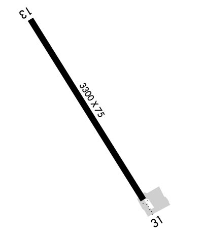
  • Runway Identifications
    Runway Identification: 14/32
    Length: 3300 ft
    Width: 75 ft
    Surface: GRAVEL-FAIR CONDITION
    Edge lights: Medium Intensity

    Treatment: NONE

     Runway: 14   Runway: 32
    Mag heading: 141°Mag heading: 321°
    Rwy Slope: -.05% DownRwy Slope: .05% Up
    Approach: Approach:
    Pattern: Left TrafficPattern: Left Traffic
    Markings: NONEMarkings: NONE
    Marking Condition: GOODMarking Condition: GOOD
    Arresting Dev: Arresting Dev:
    Lat & Long: N6131.7  W16609.1Lat. & Long.: N6131.2  W16608.5
    Elev: 19.4 ft. MSLElev: 17.6 ft. MSL
    TCH: 28 ft. AGLTCH: 28 ft. AGL
    Visual Glide Path: 3.00 degreesVisual Glide Path: 3.00 degrees
    Displaced Threshold: NoDisplaced Threshold: No
    Touchdown Zone: YESTouchdown Zone: YES
    Touchdown Elev.: 19.5 feetTouchdown Elev.: 19.5 feet
    Visual Glide Slope: 4-BOX VASI ON LEFT SIDE OF RUNWAYVisual Glide Slope: 4-BOX VASI ON LEFT SIDE OF RUNWAY
    RVR Equipment: RVR Equipment:
    RVV Equipment: NORVV Equipment: NO
    Approach Lights: ODALS - omnidirectional approach lighting systemApproach Lights:
    REIL: YESREIL: YES
    Centerline Lights: NOCenterline Lights: NO
    Touchdown lights: NOTouchdown lights: NO
    Runway Category: Runway with a Non-precision Approach having visibility minimums greater than 3/4 mileRunway Category: Runway with a Non-precision Approach having visibility minimums greater than 3/4 mile
    Declared Distances: Declared Distances:
    Obstructions: HILLObstructions: ROAD
    Marked: NOT Marked/LightedMarked: NOT Marked/Lighted
    Clearance slope: CTLG OBSTN EXCEEDS 45 DEG SLOPE.Clearance slope: 9:1
    Obstruction height: 5 feet AGLObstruction height: 15 feet AGL
    Dist. from runway: Dist. from runway: 342 feet
    Centerline offset: 75 left of centerlineCenterline offset: B
    Comments: Comments:
    C:/P: