
| ||||||||||||||||||||||||||||||||||||||||||||
| ||||||||||||||||||||||||||||||||||||||||||||
| ||||||||||||||||||||||||||||||||||||||||||||
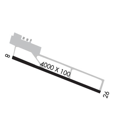
| Rwy | Rwy | |||||||
| 4000x100 | 4000' | 4000x100 | 4000' | |||||
| Runway ID | Single Wheel | Double Wheel | Double Tandem Wheel | Dual Double Wheel |
| 08/26 | N/A | N/A | N/A | N/A |
| These numbers are Advisory and are not limits. The Airport Manager should have more accurate Weight Limits | ||||
| FltPlan does not have IFR approach charts available for PAHN. |
 Airport Diagram might not be current. | |
| Facility Name: | HAINES |
| City Name: | HAINES |
| County: | HAINES |
| State abbrev: | AK |
| State Name: | ALASKA |
| Ownership: | PUBLICLY OWNED |
| Use: | OPEN TO THE PUBLIC |
| Owner's Name: | ALASKA DOT&PF SOUTHCOAST REGION |
| Address: | P.O. BOX 112506 |
| JUNEAU, AK 99811-2506 | |
| Owner's Phone: | 907-465-4512 |
| Manager's Name: | MATT BORON |
| Address: | BOX 302 |
| HAINES, AK 99827 | |
| Phone: | 907-766-2340 |
| FAA Region: | ALASKA |
| FAA Field Office: | NONE |
| Date | Sunrise | Sunset |
|---|---|---|
| 04/23/24 Tuesday | 5:23 | 20:39 |
| 04/24/24 Wednesday | 5:20 | 20:42 |
| 04/25/24 Thursday | 5:17 | 20:44 |
| 04/26/24 Friday | 5:14 | 20:46 |
| 04/27/24 Saturday | 5:12 | 20:49 |
| 04/28/24 Sunday | 5:09 | 20:51 |
| 04/29/24 Monday | 5:06 | 20:54 |
| 04/30/24 Tuesday | 5:04 | 20:56 |
| 05/01/24 Wednesday | 5:01 | 20:58 |
| 05/02/24 Thursday | 4:59 | 21:01 |
| 05/03/24 Friday | 4:56 | 21:03 |
| 05/04/24 Saturday | 4:53 | 21:05 |
| 05/05/24 Sunday | 4:51 | 21:08 |
| 05/06/24 Monday | 4:48 | 21:10 |
| Airport Attendance Schedule | UNATTENDED |
| Airport Status | OPERATIONAL (This Status can change at any time - please check NOTAMS) |
| Airport Lighting Schedule | ACTVT REIL RWY 08 & 26; PAPI RWY 08 & 26; MIRL RWY 08/26 - CTAF. |
| Airport Storage Available | Tie Downs |
| Extra Services Available | NONE |
| Wind Indicator | YES - (lighted) |
| Control Tower | NO |
| CTAF Frequency | 122.900 |
| Unicom Frequency | |
| Rotating Beacon Color | WG |
| Segmented Circle | YES |
| Landing Fee | NO |
| Airport Inspected | STATE - performed by PRIVATE CONTRACT PERSONNEL |
| Inspection Date | 09/20/2023 |
| Type of Fuel Available | Grade 100LL, JET A (freeze point -40C) |
| Airframe Repair Service | None |
| Power Plant Repair Service | None |
| Latitude | N5914.6 |
| Longitude | W13531.4 (ESTIMATED) |
| Arpt Elevation | 15ft (SURVEYED) |
| Magnetic Variation | 20E |
| 3 miles W | of HAINES |
| Traffic Pattern Altitude | |
| Sectional Chart | JUNEAU |
| Operations (Reported) | Yearly | Avg. Daily |
|---|---|---|
| General Aviation Transient | 0 | 0 |
| General Aviation Local | 200 | 1 |
| Air Taxi | 600 | 2 |
| Commerical | 0 | 0 |
| Commuter | 0 | 0 |
| Military | 0 | 0 |
| Aircraft based on Field | |
|---|---|
| General Aviation Singles | 21 |
| General Aviation Multi | 0 |
| Jet Aircraft | 0 |
| General Aviation Helicopters | 0 |
| Military Aircraft | 0 |
| Gliders | 1 |
| Ultralights | 0 |
| FSS on field | NO |
| FSS tie-in | JUNEAU |
| FSS Phone | 1-800-866-297-2236 |
| Who issues Notams | HNS |
| Notam D service at airport | YES |
| ARTCC Name | ANCHORAGE |
| Airport Certification | |
| Aircraft Rescue & Firefighting Index | None |
| Airport of Entry | No |
| Custom Landing Rights | YES |
| Joint Civil/Military | No |
| Military Landing rights | YES |
| NATIONAL PLAN OF INTEGRATED AIRPORT SYSTEMS (NPIAS) |
| GRANT AGREEMENTS UNDER FAAP/ADAP/AIP |
| CONVEYANCE UNDER SCETION 16, FEDERAL AIRPORT ACT OF 1946 OR SECTION 23, AIRPORT AND AIRWAY DEVELOPMENT ACT OF 1970 |
| ASSURANCES PURSUANT TO TITLE VI, CIVIL RIGHTS ACT OF 1964 |
| RCMD DALGT OPS ONLY. |
| ALERT: SEE GENOTS - ENROUTE CTAF FREQS. |
| WX CAMERA AVBL ON INTERNET AT HTTPS://WEATHERCAMS.FAA.GOV |
| ARPT CLSD TO ACFT OVER 12500 LBS OR MORE EXC PPR - ARPT SAFETY & SCTY; DOT & PUB FAC; P.O. BOX 112506; JUNEAU AK 99811-2506 - 907-465-1786. |
| TWY D NOT MNTND 15 OCT-30 APR. |
| NARROW APCH FM NW, MTNS BOTH SIDES; TURBC ON NW APCH, BLUFF NW. |
| FUEL SVC AVBL - 907-766-3190. |
| TWY & PRKG APRON NA. |
| COLD TEMPERATURE AIRPORT. ALTITUDE CORRECTION REQUIRED AT OR BELOW -17C. |
| BIRDS, BEARS & MOOSE ON & INVOF ARPT. |
| SAFETY AREA 4600 FT X 150 FT; 300 FT GRAVEL SAFETY AREA EACH END. |
| ARPT COND NOT MNT; ARPT MAINT ON IREG BASIS; VISUAL INSP RCMDD. |
| PAJA ONTO RWY. |
| CLSD TO ACR OPS WITH MORE THAN 30 PAX SEATS. |
| RWY 26 50 FT TREES 1000 FT SE. |
| RWY 08/2 6 SAND TO ENHANCE RWY FRICTION MAY NOT MEET FAA SPEC. |
| Runway: 08 | Runway: 26 | ||
| Mag heading: | 90° | Mag heading: | 270° |
| Rwy Slope: | -.08% Down | Rwy Slope: | .08% Up |
| Approach: | Approach: | ||
| Pattern: | Right Traffic | Pattern: | Left Traffic |
| Markings: | NONPRECISION INSTRUMENT | Markings: | NONPRECISION INSTRUMENT |
| Marking Condition: | GOOD | Marking Condition: | GOOD |
| Arresting Dev: | Arresting Dev: | ||
| Lat & Long: | N5914.7 W13532.0 | Lat. & Long.: | N5914.5 W13530.8 |
| Elev: | 15.3 ft. MSL | Elev: | 12.0 ft. MSL |
| TCH: | 57 ft. AGL | TCH: | 56 ft. AGL |
| Visual Glide Path: | 4.00 degrees | Visual Glide Path: | 4.00 degrees |
| Displaced Threshold: | No | Displaced Threshold: | No |
| Touchdown Zone: | YES | Touchdown Zone: | YES |
| Touchdown Elev.: | 15.3 feet | Touchdown Elev.: | 14.6 feet |
| Visual Glide Slope: | 4-Light PAPI on LEFT side of Runway; PAPI UNUSBL BYD 5 DEGS LEFT OF CNTRLN. | Visual Glide Slope: | 4-Light PAPI on LEFT side of Runway |
| RVR Equipment: | RVR Equipment: | ||
| RVV Equipment: | NO | RVV Equipment: | NO |
| Approach Lights: | Approach Lights: | ||
| REIL: | YES | REIL: | YES |
| Centerline Lights: | NO | Centerline Lights: | NO |
| Touchdown lights: | NO | Touchdown lights: | NO |
| Runway Category: | Runway with a Visual Approach | Runway Category: | Runway with a Visual Approach |
| Declared Distances: | Declared Distances: | ||
| Obstructions: | BRUSH | Obstructions: | BRUSH |
| Marked: | NOT Marked/Lighted | Marked: | NOT Marked/Lighted |
| Clearance slope: | Clearance slope: | ||
| Obstruction height: | 10 feet AGL | Obstruction height: | 5 feet AGL |
| Dist. from runway: | 200 feet | Dist. from runway: | 200 feet |
| Centerline offset: | Centerline offset: | ||
| Comments: | Comments: |