Click here for more info on on SMS!

PAGS

GUSTAVUS
GUSTAVUS
AK
Time Zone: Alaska
Lat: N 5825.5
Long: W 13542.4
Elev: 36
Var: -20
Longest Runway: 6720
AWOS: 125.90
CTAF: 122.5

FBO & Flight Services info for PAGS

FBOs: Update your Fuel Prices

GUSTAVUS DRAY INCPh: 907-697-2481
-
-
Service
Jet
100LL
SAF
MoGas
Full9.99      Caution: Fuel prices have not been updated in 33 days.
Last Update: 03/22/2024 13:50

Self        
 Address: PO BOX 275,1 AIRPORT WAY   GUSTAVUS, AK 99826
If you are an FBO, call 1-203-262-1700 to update your info or email: FltPlan.Advertising@garmin.com
Advertise your FBO on FltPlan.com

Runway & Approach Info for PAGS
Rwy
Length
Land Dist**
Approach*
  Rwy
Length
Land Dist**
Approach*
02
3010x60  3010'          
 
  
20
  3010x60  3010'          
 
11
6720x150  6720'          
 
  
29
  6720x150  6720'          
 
 * only ILS, LOC, LDA, and SDF approaches to a specific runway are shown
** For any Declared Landing Distance Available, please see A/FD or Approach plates
Runway Weight Capability (lbs.) Help
Runway IDSingle WheelDouble WheelDouble Tandem WheelDual Double Wheel
02/2040,000N/AN/AN/A
11/2960,000100,000N/AN/A
These numbers are Advisory and are not limits.   The Airport Manager should have more accurate Weight Limits
Approach Charts
Approaches    
Current Weather/Notams
Customs Information Send updates to Support@FltPlan.com
Customs Not Available
Database effective 05/16/2024
Airport Diagram of PAGS
Airport Diagram might not be current.

Facility Name: GUSTAVUS
City Name: GUSTAVUS
County: ANGOON
State abbrev: AK
State Name: ALASKA
   
Ownership: PUBLICLY OWNED
Use: OPEN TO THE PUBLIC
Owner's Name: ALASKA DOT&PF SOUTHCOAST REGION
Address: 6860 GLACIER HWY
 JUNEAU, AK 99801-7999
Owner's Phone: 907-465-1786
  
Manager's Name: JEFF JARVIS
Address: PO BOX 239
 GUSTAVUS, AK 99826
Phone: 907-697-2251
   
FAA Region: ALASKA
FAA Field Office: NONE


Sunrise / Sunset times for GUSTAVUS

DateSunriseSunset
04/23/24 Tuesday5:2720:37
04/24/24 Wednesday5:2420:39
04/25/24 Thursday5:2120:41
04/26/24 Friday5:1920:44
04/27/24 Saturday5:1620:46
04/28/24 Sunday5:1320:48
04/29/24 Monday5:1120:50
04/30/24 Tuesday5:0820:53
05/01/24 Wednesday5:0620:55
05/02/24 Thursday5:0320:57
05/03/24 Friday5:0121:00
05/04/24 Saturday4:5821:02
05/05/24 Sunday4:5621:04
05/06/24 Monday4:5421:06

Airport Facilities

Airport Attendance Schedule15 MAY-1SEP FRI-MON 0930-1800, 15 MAY-1 SEP TUE-THU 0600-1800, 1 SEP-15 MAY 7 Days A Week 0600-1430
Airport Status OPERATIONAL (This Status can change at any time - please check NOTAMS)
Airport Lighting ScheduleACTVT REIL RWY 11 & 29; VASI RWY 11 & 29; MIRL RWY 11/29 - CTAF
Airport Storage AvailableNONE
Extra Services AvailableNONE
Wind IndicatorYES - (unlit)
Control TowerNO
CTAF Frequency122.500
Unicom Frequency
Rotating Beacon ColorWG
Segmented CircleYES
Landing FeeNO

Airport Inspection Data

Airport InspectedFEDERAL - performed by FAA AIRPORTS FIELD PERSONNEL
Inspection Date05/18/2023

Airport Services

Type of Fuel AvailableJET A (freeze point -40C); -A CFM AVBL - 907-209-0305.
Airframe Repair ServiceNone
Power Plant Repair ServiceNone

Geographic Data

LatitudeN5825.5
LongitudeW13542.4 (ESTIMATED)
Arpt Elevation36ft (SURVEYED)
Magnetic Variation20E
0 miles NEof GUSTAVUS
Traffic Pattern Altitude
Sectional ChartJUNEAU

Aircraft Data

Operations (Reported)YearlyAvg. Daily
General Aviation Transient 20005
General Aviation Local 2001
Air Taxi 33009
Commerical 2001
Commuter 00
Military 500
Aircraft based on Field
General Aviation Singles 11
General Aviation Multi 1
Jet Aircraft 0
General Aviation Helicopters 1
Military Aircraft 0
Gliders 0
Ultralights 0

FAA Services

FSS on field NO
FSS tie-in JUNEAU
FSS Phone 1-800-866-297-2236
Who issues Notams GST
Notam D service at airport YES
ARTCC Name ANCHORAGE

Federal Status

Airport CertificationAIRPORT RECEIVING SCHEDULED AIR CARRIER SERVICE FROM CARRIERS CERTIFICATED BY THE CIVIL AERONAUTICS BOARD; ARFF SVC AVBL DURG SKED ACR OPS.
Aircraft Rescue & Firefighting IndexAIRPORT HAS A CERTIFICATE UNDER CFR PART 139
Airport of EntryNo
Custom Landing RightsNo
Joint Civil/MilitaryNo
Military Landing rightsYES

Federal Agreements

NATIONAL PLAN OF INTEGRATED AIRPORT SYSTEMS (NPIAS)
GRANT AGREEMENTS UNDER FAAP/ADAP/AIP
SURPLUS PROPERTY AGREEMENT UNDER PUBLIC LAW 289
ASSURANCES PURSUANT TO TITLE VI, CIVIL RIGHTS ACT OF 1964

Remarks

TSNT PRKG E SIDE OF RWY 02/20; ASPH SFC SOFT; ACFT OVR 12500 LBS CTC AMGR 24 HR PRIOR MON-FRI 0600-1430.
GUSTAVUS & SISTERS ISLAND WX CAMERA AVBL ON INTERNET AT HTTPS://WEATHERCAMS.FAA.GOV
24 HR PPR FOR CARGO OPS OVR 100000 LB - AMGR.
BE ALERT: SEE GENNOT - ENROUTE CTAF FREQS.
LTD ARPT MAINT SVC AVBL: 1 SEP-14 MAY 0600-1430; 15 MAY-1 SEP FRI-MON 1000-1830, TUE-THU 0600-1830. AFT HR - AMGR.
ARPT SAND LRGR GRADATION THAN FAA RCMDD/SEE AC150/5200-30.
COLD TEMPERATURE AIRPORT. ALTITUDE CORRECTION REQUIRED AT OR BELOW -18C.
TSNT PRKG AVBL GA RAMP ACES VIA TWY F.
PAJA ON RWY, TWY OR PRKG APRON NA.
WILDLIFE ON & INVOF RWY.
RWY 02/2 0 9 FT FENCE 554 FT S. NOT AVBL FOR SKED OR UNSKED ACR OPS MORE THAN 30 PAX SEATS. MNTND WINTER MONTHS; RCMD DAYLIGHT OPS ONLY.
Airport Communications & Frequencies:
CTAF Frequency:
122.500
Remarks
  • APCH/DEP SVC PRVDD BY ANCHORAGE ARTCC ON FREQS 133.2/360.65 (GUSTAVUS RCAG).
  • COMMUNICATIONS PRVDD BY JUNEAU FSS ON FREQ 122.65 (GUSTAVUS RCO).
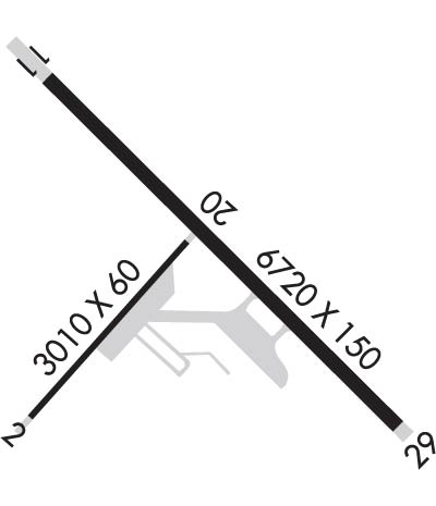
  • Runway Identifications
    Runway Identification: 02/20
    Length: 3010 ft
    Width: 60 ft
    Surface: ASPHALT-GOOD CONDITION
    Edge lights:

    Treatment: NONE
    Weight: PCN 18 /F/B/X/T

     Runway: 02   Runway: 20
    Mag heading: 21°Mag heading: 201°
    Rwy Slope: .06% UpRwy Slope: -.06% Down
    Approach: Approach:
    Pattern: Left TrafficPattern: Left Traffic
    Markings: NONPRECISION INSTRUMENTMarkings: NONPRECISION INSTRUMENT
    Marking Condition: GOODMarking Condition: GOOD
    Arresting Dev: Arresting Dev:
    Lat & Long: N5825.2  W13543.1Lat. & Long.: N5825.6  W13542.5
    Elev: 30.5 ft. MSLElev: 32.4 ft. MSL
    TCH: TCH:
    Visual Glide Path: Visual Glide Path:
    Displaced Threshold: NoDisplaced Threshold: No
    Touchdown Zone: YESTouchdown Zone: YES
    Touchdown Elev.: 32.5 feetTouchdown Elev.: 32.5 feet
    Visual Glide Slope: Visual Glide Slope:
    RVR Equipment: RVR Equipment:
    RVV Equipment: NORVV Equipment: NO
    Approach Lights: Approach Lights:
    REIL: NOREIL: NO
    Centerline Lights: NOCenterline Lights: NO
    Touchdown lights: NOTouchdown lights: NO
    Runway Category: Runway with a Visual ApproachRunway Category: Runway with a Visual Approach
    Declared Distances: Declared Distances:
    Obstructions: TREESObstructions: TREES
    Marked: NOT Marked/LightedMarked: NOT Marked/Lighted
    Clearance slope: 25:1Clearance slope: 14:1
    Obstruction height: 18 feet AGLObstruction height: 72 feet AGL
    Dist. from runway: 650 feetDist. from runway: 1200 feet
    Centerline offset: Centerline offset: B
    Comments: Comments:
    Runway Identification: 11/29
    Length: 6720 ft
    Width: 150 ft
    Surface: ASPHALT-GOOD CONDITION
    Edge lights: Medium Intensity

    Treatment: GROOVED
    Weight: PCN 28 /F/B/X/T

     Runway: 11   Runway: 29
    Mag heading: 115°Mag heading: 295°
    Rwy Slope: -.10% DownRwy Slope: .10% Up
    Approach: Approach:
    Pattern: Left TrafficPattern: Left Traffic
    Markings: NONPRECISION INSTRUMENTMarkings: NONPRECISION INSTRUMENT
    Marking Condition: GOODMarking Condition: GOOD
    Arresting Dev: Arresting Dev:
    Lat & Long: N5826.0  W13543.0Lat. & Long.: N5825.2  W13541.6
    Elev: 36.2 ft. MSLElev: 29.2 ft. MSL
    TCH: 35 ft. AGLTCH: 39 ft. AGL
    Visual Glide Path: 3.00 degreesVisual Glide Path: 3.00 degrees
    Displaced Threshold: NoDisplaced Threshold: No
    Touchdown Zone: YESTouchdown Zone: YES
    Touchdown Elev.: 36.3 feetTouchdown Elev.: 32.6 feet
    Visual Glide Slope: 4-BOX VASI ON RIGHT SIDE OF RUNWAYVisual Glide Slope: 4-BOX VASI ON LEFT SIDE OF RUNWAY
    RVR Equipment: RVR Equipment:
    RVV Equipment: NORVV Equipment: NO
    Approach Lights: Approach Lights:
    REIL: YESREIL: YES
    Centerline Lights: NOCenterline Lights: NO
    Touchdown lights: NOTouchdown lights: NO
    Runway Category: Runway with a Visual ApproachRunway Category: Runway with a Non-precision Approach having visibility minimums greater than 3/4 mile
    Declared Distances: Declared Distances:
    C:3/P: