Click here for more info on on SMS!

PAGB

GALBRAITH LAKE AIRPORT (GBH)
GALBRAITH LAKE
AK
Time Zone: Alaska
Lat: N 6828.8
Long: W 14929.4
Elev: 2663
Var: -16
Longest Runway: 5182
CTAF: 122.9

FBO & Flight Services info for PAGB

FBOs: Update your Fuel Prices

AIRPORTPh: 907-787-8964
-
Freq: 122.9
Service
Jet
100LL
SAF
MoGas
Fuel Avail: NO FUEL AVAILABLE
Full        Last Update: 04/19/2024 00:01:48

Self        
RUNWAY - GRAVEL
-
-
 
If you are an FBO, call 1-203-262-1700 to update your info or email: FltPlan.Advertising@garmin.com
Advertise your FBO on FltPlan.com

Runway & Approach Info for PAGB
Rwy
Length
Land Dist**
Approach*
  Rwy
Length
Land Dist**
Approach*
14
5182x150  5182'          
 
  
32
  5182x150  5182'          
 
 * only ILS, LOC, LDA, and SDF approaches to a specific runway are shown
** For any Declared Landing Distance Available, please see A/FD or Approach plates
Runway Weight Capability (lbs.) Help
Runway IDSingle WheelDouble WheelDouble Tandem WheelDual Double Wheel
14/32N/AN/AN/AN/A
These numbers are Advisory and are not limits.   The Airport Manager should have more accurate Weight Limits
Approach Charts
FltPlan does not have IFR approach charts available for PAGB.
Current Weather/Notams
Customs Information Send updates to Support@FltPlan.com
Customs Not Available
Database effective 04/18/2024
Airport Diagram of PAGB
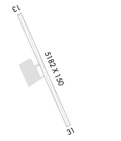
Airport Diagram might not be current.

Facility Name: GALBRAITH LAKE
City Name: GALBRAITH LAKE
County: NORTH SLOPE
State abbrev: AK
State Name: ALASKA
   
Ownership: PUBLICLY OWNED
Use: OPEN TO THE PUBLIC
Owner's Name: ALASKA DOT&PF NORTHERN REGION
Address: 2301 PEGER RD
 FAIRBANKS, AK 99701
Owner's Phone: 907-451-2207
  
Manager's Name: RENIER SWART; 907-787-4402/4405.
Address: P.O. BOX 196660, MS 530B
 ANCHORAGE, AK 99512
Phone: 907-787-8959
   
FAA Region: ALASKA
FAA Field Office: NONE


Sunrise / Sunset times for GALBRAITH LAKE

DateSunriseSunset
04/18/24 Thursday5:4622:11
04/19/24 Friday5:4122:15
04/20/24 Saturday5:3622:19
04/21/24 Sunday5:3222:23
04/22/24 Monday5:2722:28
04/23/24 Tuesday5:2222:32
04/24/24 Wednesday5:1822:36
04/25/24 Thursday5:1322:41
04/26/24 Friday5:0822:45
04/27/24 Saturday5:0322:50
04/28/24 Sunday4:5922:54
04/29/24 Monday4:5422:59
04/30/24 Tuesday4:4923:04
05/01/24 Wednesday4:4423:08

Airport Facilities

Airport Attendance ScheduleUNATTENDED
Airport Status OPERATIONAL (This Status can change at any time - please check NOTAMS)
Airport Lighting ScheduleACTVT ODALS RWY 14; PAPI RWY 14 & 32 - CTAF.
Airport Storage AvailableNONE
Extra Services AvailableNONE
Wind IndicatorYES - (lighted)
Control TowerNO
CTAF Frequency122.900
Unicom Frequency
Rotating Beacon ColorWG
Segmented CircleYES
Landing FeeNO

Airport Inspection Data

Airport InspectedFEDERAL - performed by PRIVATE CONTRACT PERSONNEL
Inspection Date07/06/2023

Airport Services

Type of Fuel AvailableNone
Airframe Repair ServiceNone
Power Plant Repair ServiceNone

Geographic Data

LatitudeN6828.8
LongitudeW14929.4 (ESTIMATED)
Arpt Elevation2662ft (SURVEYED)
Magnetic Variation16E
2 miles Nof GALBRAITH LAKE
Traffic Pattern Altitude
Sectional ChartPOINT BARROW

Aircraft Data

Operations (Reported)YearlyAvg. Daily
General Aviation Transient 600
General Aviation Local 900
Air Taxi 1750
Commerical 260
Commuter 00
Military 00
Aircraft based on Field
General Aviation Singles 0
General Aviation Multi 0
Jet Aircraft 0
General Aviation Helicopters 0
Military Aircraft 0
Gliders 0
Ultralights 0

FAA Services

FSS on field NO
FSS tie-in FAIRBANKS
FSS Phone 1-800-866-248-6516
Who issues Notams GBH
Notam D service at airport YES
ARTCC Name ANCHORAGE

Federal Status

Airport Certification
Aircraft Rescue & Firefighting IndexNone
Airport of EntryNo
Custom Landing RightsNo
Joint Civil/MilitaryNo
Military Landing rightsYES

Federal Agreements

NATIONAL PLAN OF INTEGRATED AIRPORT SYSTEMS (NPIAS)

Remarks

LMTD SNOW REMOVAL.
COLD TEMPERATURE AIRPORT. ALTITUDE CORRECTION REQUIRED AT OR BELOW -32C.
RWY 14/3 2 100 FT OVERRUNS.
RWY 14/3 2 COND UNMNT; RCMD VISUAL INSP PRIOR TO USE.
Airport Communications & Frequencies:
CTAF Frequency:
122.900
Remarks
  • APCH/DEP SVC PRVDD BY ANCHORAGE ARTCC (ZAN) ON 134.6 (GALBRAITH RCAG).
  • Runway Identifications
    Runway Identification: 14/32
    Length: 5182 ft
    Width: 150 ft
    Surface: GRAVEL-GOOD CONDITION
    Edge lights: Medium Intensity

    Treatment: NONE

     Runway: 14   Runway: 32
    Mag heading: 136°Mag heading: 316°
    Rwy Slope: -.14% DownRwy Slope: .14% Up
    Approach: Approach:
    Pattern: Left TrafficPattern: Left Traffic
    Markings: Markings:
    Marking Condition: GOODMarking Condition: GOOD
    Arresting Dev: Arresting Dev:
    Lat & Long: N6829.2  W14929.9Lat. & Long.: N6828.4  W14928.9
    Elev: 2662.5 ft. MSLElev: 2655.0 ft. MSL
    TCH: 31 ft. AGLTCH: 45 ft. AGL
    Visual Glide Path: 3.00 degreesVisual Glide Path: 4.00 degrees
    Displaced Threshold: NoDisplaced Threshold: No
    Touchdown Zone: YESTouchdown Zone: YES
    Touchdown Elev.: 2662.7 feetTouchdown Elev.: 2659.4 feet
    Visual Glide Slope: 2-Light PAPI on LEFT side of RunwayVisual Glide Slope: 2-Light PAPI on LEFT side of Runway
    RVR Equipment: RVR Equipment:
    RVV Equipment: NORVV Equipment: NO
    Approach Lights: ODALS - omnidirectional approach lighting systemApproach Lights:
    REIL: YESREIL: NO
    Centerline Lights: NOCenterline Lights: NO
    Touchdown lights: NOTouchdown lights: NO
    Runway Category: Runway with a Non-precision Approach having visibility minimums greater than 3/4 mileRunway Category: Runway with a Non-precision Approach having visibility minimums greater than 3/4 mile
    Declared Distances: Declared Distances:
    Obstructions: Obstructions: ROAD
    Marked: Marked: NOT Marked/Lighted
    Clearance slope: 50:1Clearance slope:
    Obstruction height: Obstruction height: 15 feet AGL
    Dist. from runway: Dist. from runway: 0 feet
    Centerline offset: Centerline offset: 80 feet left of centerline
    Comments: Comments:
    C:/P: