
| |||||
|
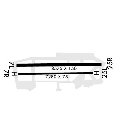
| Rwy | Rwy | |||||||
| 8575x150 | 8575' | 8575x150 | 8575' | |||||
| Runway ID | Single Wheel | Double Wheel | Double Tandem Wheel | Dual Double Wheel |
| 07/25 | N/A | 38,000 | N/A | N/A |
| H1 | N/A | N/A | N/A | N/A |
| H4 | N/A | N/A | N/A | N/A |
| H5 | N/A | N/A | N/A | N/A |
| H6 | N/A | N/A | N/A | N/A |
| H7 | N/A | N/A | N/A | N/A |
| These numbers are Advisory and are not limits. The Airport Manager should have more accurate Weight Limits | ||||
 Airport Diagram might not be current. | |
| Facility Name: | LADD AAF |
| City Name: | FAIRBANKS/FT WAINWRIGHT |
| County: | FAIRBANKS NORTH STAR |
| State abbrev: | AK |
| State Name: | ALASKA |
| Ownership: | ARMY OWNED |
| Use: | PRIVATE; 24 HR PPR FOR TSNT - D317-353-7212/6514/C907-353-7212/6514. |
| Owner's Name: | U.S. ARMY |
| Address: | U.S. ARMY FORCES COMMAND |
| ATLANTA, GA | |
| Owner's Phone: | |
| Manager's Name: | HQ 172 INFANTRY BRIGADE |
| Address: | FT RICHARDSON |
| ALASKA 99505 | |
| Phone: | 907-353-7022 |
| FAA Region: | ALASKA |
| FAA Field Office: | NONE |
| Date | Sunrise | Sunset |
|---|---|---|
| 04/24/24 Wednesday | 5:39 | 22:00 |
| 04/25/24 Thursday | 5:35 | 22:03 |
| 04/26/24 Friday | 5:32 | 22:06 |
| 04/27/24 Saturday | 5:28 | 22:10 |
| 04/28/24 Sunday | 5:24 | 22:13 |
| 04/29/24 Monday | 5:21 | 22:16 |
| 04/30/24 Tuesday | 5:17 | 22:20 |
| 05/01/24 Wednesday | 5:14 | 22:23 |
| 05/02/24 Thursday | 5:10 | 22:27 |
| 05/03/24 Friday | 5:06 | 22:30 |
| 05/04/24 Saturday | 5:03 | 22:33 |
| 05/05/24 Sunday | 4:59 | 22:37 |
| 05/06/24 Monday | 4:56 | 22:40 |
| 05/07/24 Tuesday | 4:52 | 22:44 |
| Airport Attendance Schedule | MON-FRI 1700-0800++ |
| Airport Status | OPERATIONAL (This Status can change at any time - please check NOTAMS) |
| Airport Lighting Schedule | WHEN TWR CLSD ACTVT AFLD LGTS - CTAF |
| Airport Storage Available | Hanger |
| Extra Services Available | Cargo Handling |
| Wind Indicator | YES - (unlit) |
| Control Tower | YES |
| CTAF Frequency | 125.000 |
| Unicom Frequency | |
| Rotating Beacon Color | WG |
| Segmented Circle | YES |
| Landing Fee |
| Airport Inspected | No Inspection Data Available performed by FAA AIRPORTS FIELD PERSONNEL |
| Inspection Date | 04/15/1979 |
| Type of Fuel Available | 8 |
| Airframe Repair Service | None |
| Power Plant Repair Service | None |
| Latitude | N6450.3 |
| Longitude | W14736.9 (ESTIMATED) |
| Arpt Elevation | 448ft (SURVEYED) |
| Magnetic Variation | 17E |
| 2 miles E | of FAIRBANKS/FT WAINWRIGHT |
| Traffic Pattern Altitude | TPA R/W 1200 FT; F/W PISTON 1500 FT; F/W TURBINE 2000 FT. |
| Sectional Chart | FAIRBANKS |
| Operations (Reported) | Yearly | Avg. Daily |
|---|---|---|
| General Aviation Transient | 1000 | 3 |
| General Aviation Local | 3000 | 8 |
| Air Taxi | 0 | 0 |
| Commerical | 0 | 0 |
| Commuter | 0 | 0 |
| Military | 60000 | 164 |
| Aircraft based on Field | |
|---|---|
| General Aviation Singles | 13 |
| General Aviation Multi | 0 |
| Jet Aircraft | 0 |
| General Aviation Helicopters | 0 |
| Military Aircraft | 90 |
| Gliders | 0 |
| Ultralights | 0 |
| FSS on field | NO |
| FSS tie-in | FAIRBANKS |
| FSS Phone | 1-800-866-248-6516 |
| Who issues Notams | PAFB |
| Notam D service at airport | YES |
| ARTCC Name | ANCHORAGE |
| Airport Certification | |
| Aircraft Rescue & Firefighting Index | None |
| Airport of Entry | No |
| Custom Landing Rights | No |
| Joint Civil/Military | No |
| Military Landing rights | No |
| NORTH TFC PAT R/W & MQ-1 GRAY EAGLE ONLY; LRG ACFT - RAMP PRKG; SMALL ACFT TIE DOWN NOT AVBL. |
| BIRD ACT INVOF ARPT. |
| ALERT: NMRS NIGHT DEVICE ACFT OPS INVOF LADD AAF; EXP NMRS DIMLY LIT ACFT IN TANNANA FLATS & YUKON TRNG AREA DURG HR OF DARKNESS & WKDAY SEP-APR. |
| (A35) T200; ST175; TT340; TDT714. |
| CTN: 100 FT MKD LGT POLE 3/4 NM SE. |
| MINS BASED ON FBK WX OBS. |
| ASOS 119.275 ASSOCD WITH R-2205 YUKON TRNG RANGE; ASOS 18.525 ASSOCD WITH R-2211 BLAIR LAKE TRNG RANGE. PMSV LMTD TO LINE OF SIGHT; RECEPTION BLW 5000 FT MSL LMTD FM 210-100 WI 100 NM BY TRRN, NO LMT ABV 5000 FT WI 50 NM; RECEPTION 3500-12000 FT LMTD FM 100-210 FM 50-100 NM BY TRRN, NO LMT ABV 12000 FT WI 100 NM. PMSV UNMON WHEN FBK TWR CLSD. SFC VIS RSTRD FM 020-050 DUE TO HNGR 1 & FM 250-350 DUE TO ATCT & BLDGS. |
| ALL HOP DAY VMC ONLY. |
| TWY A, B, C, D, E, F, G, SECTIONS OF N & S DO NOT HAVE SHOULDERS. |
| DE-ICE SVCS NOT AVBL. |
| FIRING RANGE S OF FLD FOR ADZY CTC ATCT OR OPS. |
| PMSV METRO 142.1 OR 381.375. WX MON-SAT 0900Z-0900Z++ EXC HOL - D317-353-7111/C907-353-7111S; AFT HR 15TH OWS SCOTT AFB, IL - D312-576-9755/9702/C618-256-9755/9702 OR BY NOTAM. METWATCH & MEDEVAC EMERG AFT HR - C907-382-6518. |
| SVC: PAPI MAINT LAST WED OF MONTH 0900-1200/1800Z-2100Z++; PAPI NA DURG THIS TIME. |
| SVC: US CUSTOMS & INTL TRASH NOT AVBL. |
| EDGE LGTS TWY H & PTNS OF TWY N & S GTR THAN 10 FT FM TWY SIDE STRIPES. |
| GCA 121.3 118.05 276.4; MON-FRI 1700-0100++ EXC HOL. |
| RAPID HOT REFUELING POINTS OPS CLSD SAT, SUN, HOL; OTR TIMES BY NOTAM. AVN UNITS CTC THEIR OPS FOR COLD FUEL. |
| CTN: UNLGT TWRS IN ALPHA SOD CNTR INOP. |
| MED EVAC PAD FOR F/W AT OPS RAMP; R/W EVAC PAD AT HOSPITAL; 15 MIN NOTICE RQRD. |
| DURG WX STATION EVAC - 907-382-6518. |
| CTN: LGTD HWY PARL TO & N OF RWY 07/25 CAN BE CONFUSED WITH RWY. |
| INSPN BY DEPT OF ARMY. |
| RWY 07/2 5 CTN: ROAD APCH END OF RWY 07 & 25. NO OVRNS. |
| RWY 07 ACTV RAILROAD 556 FT FM DER RUNS THRU CLEAR ZONE PERPENDICULAR TO CNTRLN; WHEN RAILROAD ACTV ATCT WILL ADVISE LNDG & DEP NA. 15 FT ROAD 387 FT E OF DER 349 FT FM DER RUNS THRU CLEAR ZONE PERPENDICULAR TO EXTDD CNTRLN; RIVER 556 FT FM DER RUNS THRU CLEAR ZONE PERPENDICULAR TO EXTDD CNTRLN. |
| RWY 25 15 FT ROAD 349 FT W OF DER; 23 FT RAILROAD TRACKS 556 FT W OF DER; 25 FT TREES 556 FT W OF DER. ROAD 387 FT FM DER RUNS THRU CLEAR ZONE PERPENDICULAR TO EXTDD CNTRLN; RIVER 477 FT FM DER RUNS THRU CLEAR ZONE PERPENDICULAR TO EXTDD CNTRLN. ROAD TFC IS CTLD BY ATCT WHEN OPN. |
| RWY H1 DESIGNATED: HELIPAD S |
| RWY 07/2 5 SEASONAL CLIMATE COND EFCTS WEIGHT BRG CPTY. |
| RWY 07/2 5 PCN JUN-FEB 130/F/A/W/T; PCN MAR-MAY 112/F/D/W/T. |
Airport Communications & Frequencies:
| |||||||||||||||||||||||||||||||||||||
| Runway: 07 | Runway: 25 | ||
| Mag heading: | 72° | Mag heading: | 252° |
| Rwy Slope: | .06% Up | Rwy Slope: | -.06% Down |
| Approach: | Approach: | ||
| Pattern: | Right Traffic | Pattern: | Left Traffic |
| Markings: | PRECISION INSTRUMENT | Markings: | PRECISION INSTRUMENT |
| Marking Condition: | GOOD | Marking Condition: | GOOD |
| Arresting Dev: | Arresting Dev: | ||
| Lat & Long: | N6450.2 W14738.5 | Lat. & Long.: | N6450.3 W14735.2 |
| Elev: | 442.8 ft. MSL | Elev: | 447.9 ft. MSL |
| TCH: | 67 ft. AGL | TCH: | 67 ft. AGL |
| Visual Glide Path: | 3.00 degrees | Visual Glide Path: | 3.30 degrees |
| Displaced Threshold: | No | Displaced Threshold: | No |
| Touchdown Zone: | YES | Touchdown Zone: | YES |
| Touchdown Elev.: | 445.5 feet | Touchdown Elev.: | 448.6 feet |
| Visual Glide Slope: | 4-Light PAPI on LEFT side of Runway | Visual Glide Slope: | 4-Light PAPI on LEFT side of Runway |
| RVR Equipment: | RVR Equipment: | ||
| RVV Equipment: | NO | RVV Equipment: | NO |
| Approach Lights: | ALSF1 - standard 2,400 foot high intensity approach lighting system with sequenced flashers, Category I; NSTD. | Approach Lights: | ALSF1 - standard 2,400 foot high intensity approach lighting system with sequenced flashers, Category I; NSTD. |
| REIL: | YES | REIL: | YES |
| Centerline Lights: | NO | Centerline Lights: | NO |
| Touchdown lights: | NO | Touchdown lights: | NO |
| Runway Category: | Runway Category: | ||
| Declared Distances: | Declared Distances: | ||
| Obstructions: | TREES ROAD | Obstructions: | TREES/ROAD |
| Marked: | NOT Marked/Lighted | Marked: | NOT Marked/Lighted |
| Clearance slope: | 10:1 | Clearance slope: | 20:1 |
| Obstruction height: | Obstruction height: | ||
| Dist. from runway: | 500 feet | Dist. from runway: | 300 feet |
| Centerline offset: | Centerline offset: | ||
| Comments: | Comments: |
