
| ||||||||||||||||||||||||||||||||
| ||||||||||||||||||||||||||||||||
| ||||||||||||||||||||||||||||||||
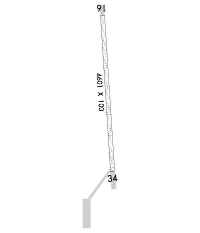
| Rwy | Rwy | |||||||
| 4601x100 | 4601' | 4601x100 | 4601' | |||||
| Runway ID | Single Wheel | Double Wheel | Double Tandem Wheel | Dual Double Wheel |
| 16/34 | N/A | N/A | N/A | N/A |
| These numbers are Advisory and are not limits. The Airport Manager should have more accurate Weight Limits | ||||
 Airport Diagram might not be current. | |
| Facility Name: | EMMONAK |
| City Name: | EMMONAK |
| County: | KUSILVAK |
| State abbrev: | AK |
| State Name: | ALASKA |
| Ownership: | PUBLICLY OWNED |
| Use: | OPEN TO THE PUBLIC |
| Owner's Name: | ALASKA DOT&PF NORTHERN REGION |
| Address: | 2301 PEGER ROAD |
| FAIRBANKS, AK 99709 | |
| Owner's Phone: | 907-451-2200 |
| Manager's Name: | JOHN WILSON |
| Address: | BOX 192 |
| UNALAKLEET, AK 99684 | |
| Phone: | (907) 625-1025 |
| FAA Region: | ALASKA |
| FAA Field Office: | NONE |
| Date | Sunrise | Sunset |
|---|---|---|
| 04/24/24 Wednesday | 6:59 | 22:55 |
| 04/25/24 Thursday | 6:55 | 22:58 |
| 04/26/24 Friday | 6:52 | 23:01 |
| 04/27/24 Saturday | 6:49 | 23:04 |
| 04/28/24 Sunday | 6:46 | 23:07 |
| 04/29/24 Monday | 6:42 | 23:09 |
| 04/30/24 Tuesday | 6:39 | 23:12 |
| 05/01/24 Wednesday | 6:36 | 23:15 |
| 05/02/24 Thursday | 6:33 | 23:18 |
| 05/03/24 Friday | 6:30 | 23:21 |
| 05/04/24 Saturday | 6:27 | 23:24 |
| 05/05/24 Sunday | 6:24 | 23:27 |
| 05/06/24 Monday | 6:21 | 23:30 |
| 05/07/24 Tuesday | 6:17 | 23:33 |
| Airport Attendance Schedule | UNATTENDED |
| Airport Status | OPERATIONAL (This Status can change at any time - please check NOTAMS) |
| Airport Lighting Schedule | ACTVT MIRL RY 16/34; VASI RYS 16 & 34 AND REIL RY 34 - CTAF. |
| Airport Storage Available | NONE |
| Extra Services Available | NONE |
| Wind Indicator | YES - (lighted) |
| Control Tower | NO |
| CTAF Frequency | 122.900 |
| Unicom Frequency | |
| Rotating Beacon Color | WG |
| Segmented Circle | YES |
| Landing Fee | NO |
| Airport Inspected | CONTRACTOR - performed by PRIVATE CONTRACT PERSONNEL |
| Inspection Date | 06/05/2023 |
| Type of Fuel Available | None |
| Airframe Repair Service | None |
| Power Plant Repair Service | None |
| Latitude | N6247.2 |
| Longitude | W16429.4 (ESTIMATED) |
| Arpt Elevation | 16ft (SURVEYED) |
| Magnetic Variation | 14E |
| 1 miles W | of EMMONAK |
| Traffic Pattern Altitude | |
| Sectional Chart | BETHEL |
| Operations (Reported) | Yearly | Avg. Daily |
|---|---|---|
| General Aviation Transient | 0 | 0 |
| General Aviation Local | 0 | 0 |
| Air Taxi | 500 | 1 |
| Commerical | 0 | 0 |
| Commuter | 0 | 0 |
| Military | 0 | 0 |
| Aircraft based on Field | |
|---|---|
| General Aviation Singles | 1 |
| General Aviation Multi | 0 |
| Jet Aircraft | 0 |
| General Aviation Helicopters | 0 |
| Military Aircraft | 0 |
| Gliders | 0 |
| Ultralights | 0 |
| FSS on field | NO |
| FSS tie-in | KENAI |
| FSS Phone | 1-800-866-864-1737 |
| Who issues Notams | ENM |
| Notam D service at airport | YES |
| ARTCC Name | ANCHORAGE |
| Airport Certification | |
| Aircraft Rescue & Firefighting Index | None |
| Airport of Entry | No |
| Custom Landing Rights | No |
| Joint Civil/Military | No |
| Military Landing rights | No |
| NATIONAL PLAN OF INTEGRATED AIRPORT SYSTEMS (NPIAS) |
| GRANT AGREEMENTS UNDER FAAP/ADAP/AIP |
| ASSURANCES PURSUANT TO TITLE VI, CIVIL RIGHTS ACT OF 1964 |
| THIS AIRPORT HAS BEEN SURVEYED BY THE NATIONAL GEODETIC SURVEY. |
| RY CONDITION NOT MONITORED; RECOMMEND VISUAL INSPECTION PRIOR TO LANDING. |
| WX CAMERA AVBL ON INTERNET AT HTTPS://WEATHERCAMS.FAA.GOV |
| RAVENS AND GULLS ON AND INVOF ARPT. |
| RWY 16/3 4 SAFETY AREA LENGTH 5000 FT; SAFETY AREA ROUGH BOTH RY ENDS. |
Airport Communications & Frequencies:
| |||||||
| Runway: 16 | Runway: 34 | ||
| Mag heading: | 163° | Mag heading: | 343° |
| Rwy Slope: | .00% | Rwy Slope: | .00% |
| Approach: | Approach: | ||
| Pattern: | Left Traffic | Pattern: | Left Traffic |
| Markings: | Markings: | ||
| Marking Condition: | Marking Condition: | ||
| Arresting Dev: | Arresting Dev: | ||
| Lat & Long: | N6247.5 W16429.5 | Lat. & Long.: | N6246.8 W16429.4 |
| Elev: | 16.2 ft. MSL | Elev: | 16.2 ft. MSL |
| TCH: | 32 ft. AGL | TCH: | 32 ft. AGL |
| Visual Glide Path: | 3.00 degrees | Visual Glide Path: | 3.00 degrees |
| Displaced Threshold: | No | Displaced Threshold: | No |
| Touchdown Zone: | YES | Touchdown Zone: | YES |
| Touchdown Elev.: | 16.2 feet | Touchdown Elev.: | 16.2 feet |
| Visual Glide Slope: | 4-BOX VASI ON LEFT SIDE OF RUNWAY | Visual Glide Slope: | 4-BOX VASI ON LEFT SIDE OF RUNWAY |
| RVR Equipment: | RVR Equipment: | ||
| RVV Equipment: | NO | RVV Equipment: | NO |
| Approach Lights: | Approach Lights: | ||
| REIL: | NO | REIL: | YES |
| Centerline Lights: | NO | Centerline Lights: | NO |
| Touchdown lights: | NO | Touchdown lights: | NO |
| Runway Category: | Runway with a Non-precision Approach having visibility minimums greater than 3/4 mile | Runway Category: | Runway with a Non-precision Approach having visibility minimums greater than 3/4 mile |
| Declared Distances: | Declared Distances: |
