
| |||||
|
| Rwy | Rwy | |||||||
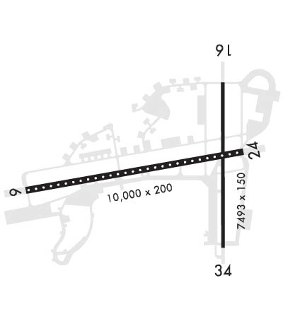
| 10000x200 | 10000' | 110.30 - 061° | 10000x200 | 10000' | ||||
| 7493x150 | 7493' | 7493x150 | 7493' | |||||
| Runway ID | Single Wheel | Double Wheel | Double Tandem Wheel | Dual Double Wheel |
| 06/24 | N/A | N/A | N/A | N/A |
| 16/34 | N/A | N/A | N/A | N/A |
| These numbers are Advisory and are not limits. The Airport Manager should have more accurate Weight Limits | ||||
 Airport Diagram might not be current. | |
| Facility Name: | ELMENDORF AFB |
| City Name: | ANCHORAGE |
| County: | ANCHORAGE |
| State abbrev: | AK |
| State Name: | ALASKA |
| Ownership: | AIR FORCE OWNED |
| Use: | PRIVATE |
| Owner's Name: | U S GOVT USAF |
| Address: | 30SS/DOFJ |
| ELMENDORF AFB, AK 99506 | |
| Owner's Phone: | 907-552-2107 |
| Manager's Name: | AIRFIELD MGR |
| Address: | 300SS/DOFJ |
| ELMENDORF AFB, AK 99506 | |
| Phone: | 907-552-2444 |
| FAA Region: | ALASKA |
| FAA Field Office: | NONE |
| Date | Sunrise | Sunset |
|---|---|---|
| 04/25/24 Thursday | 6:05 | 21:51 |
| 04/26/24 Friday | 6:02 | 21:53 |
| 04/27/24 Saturday | 5:59 | 21:56 |
| 04/28/24 Sunday | 5:56 | 21:59 |
| 04/29/24 Monday | 5:53 | 22:01 |
| 04/30/24 Tuesday | 5:50 | 22:04 |
| 05/01/24 Wednesday | 5:47 | 22:07 |
| 05/02/24 Thursday | 5:44 | 22:09 |
| 05/03/24 Friday | 5:41 | 22:12 |
| 05/04/24 Saturday | 5:39 | 22:15 |
| 05/05/24 Sunday | 5:36 | 22:17 |
| 05/06/24 Monday | 5:33 | 22:20 |
| 05/07/24 Tuesday | 5:30 | 22:23 |
| 05/08/24 Wednesday | 5:27 | 22:25 |
| Airport Attendance Schedule | CONTINUOUS |
| Airport Status | OPERATIONAL (This Status can change at any time - please check NOTAMS) |
| Airport Lighting Schedule | |
| Airport Storage Available | NONE |
| Extra Services Available | Cargo Handling |
| Wind Indicator | YES - (unlit) |
| Control Tower | YES |
| CTAF Frequency | |
| Unicom Frequency | |
| Rotating Beacon Color | WG |
| Segmented Circle | NO |
| Landing Fee |
| Airport Inspected | No Inspection Data Available performed by the OWNER |
| Inspection Date | 07/23/1979 |
| Type of Fuel Available | 8 |
| Airframe Repair Service | None |
| Power Plant Repair Service | None |
| Latitude | N6115.1 |
| Longitude | W14948.4 (ESTIMATED) |
| Arpt Elevation | 213ft (SURVEYED) |
| Magnetic Variation | 18E |
| 3 miles NE | of ANCHORAGE |
| Traffic Pattern Altitude | TPA: OVHD 1700 FT MSL, CONVENTIONAL 1200 FT MSL, HEL/LGT 800 FT MSL. |
| Sectional Chart | ANCHORAGE |
| Operations (Reported) | Yearly | Avg. Daily |
|---|---|---|
| General Aviation Transient | 500 | 1 |
| General Aviation Local | 7600 | 21 |
| Air Taxi | 0 | 0 |
| Commerical | 0 | 0 |
| Commuter | 0 | 0 |
| Military | 78500 | 215 |
| Aircraft based on Field | |
|---|---|
| General Aviation Singles | 14 |
| General Aviation Multi | 1 |
| Jet Aircraft | 0 |
| General Aviation Helicopters | 0 |
| Military Aircraft | 69 |
| Gliders | 0 |
| Ultralights | 0 |
| FSS on field | NO |
| FSS tie-in | KENAI |
| FSS Phone | 1-800-866-864-1737 |
| Who issues Notams | PAED |
| Notam D service at airport | YES |
| ARTCC Name | ANCHORAGE |
| Airport Certification | ARFF FAA INDEX D/ CAT 8/10. |
| Aircraft Rescue & Firefighting Index | None |
| Airport of Entry | No |
| Custom Landing Rights | No |
| Joint Civil/Military | No |
| Military Landing rights | No |
| THIS AIRPORT HAS BEEN SURVEYED BY THE NATIONAL GEODETIC SURVEY. |
| CTN: RIDGE EXTDG FM 260-020 DEG 1-2 MI FM TWR PREVENTS FOG OBS OVR KNIK ARM. VIS MAY DROP RAPIDLY AS FOG POURS OVR RIDGE. |
| UNA TO MEET R2203 DEP RSTRNS ADVISE ATC PRIOR; CSDR RWY 24 DEP. SEE ATC NOTES IN GIANT RPRT. |
| MNTN IDLE PWR ON OUTBOARD ENG DURG TAX. |
| HOLD SHORT LINE SIGNS NA ON INTERSECTING RWYS. |
| HGR SPACE & WARM STORAGE LMTD OCT-MAY. |
| FQT ACT IN R2203; WHEN UNA TO AVOID CTC ATCT. |
| SPEC ATC RULES FAR PART 93; SEE REG NOTICES IN SUPPL. |
| LMTD WKEND MAINT SVC. |
| PREVENTIVE MAINT: TACAN WED & FRI 1600-1700Z; ILS TUE & THU 1500-1700Z; PAR SAT-SUN 1800-2000Z; ASR SAT-SUN 2000-2200. |
| JOAP, JOINT OIL ANALYSIS PROGRAM AVBL. LHNIT, LOW & HIGH PRES NITROGEN SVCG AVBL. JOAP & LOW & HIGH PRES NITROGEN SVC DURG DUTY HOURS; AFT HR ON REQ. DE-ICE, TYPE 1 DE-ICE LIFTOFF P-88; TYPE 4 ANTI-ICE CLARIANT SAFEWING MP-LAUNCH. |
| CHANGE JET ACFT STARTING UNITS (JASU) TO, (A/M32A-86), MC-1A), (MC-2A), (AM32A-60A). (AM32-95)150 +/-5 LBS/MIN (2055 +/-68CFM) AT 51 +/-02 PSIA. LASS 150 +/-5 LBS/MIN @ 49 +/-2 PSIA. |
| OIL: O-123, O-128, O-133, O-148, O-156, JOAP. |
| FLUID: PRESAIR & NITROGEN-LHNIT. |
| QUIET HR 0630-1400Z WKDAY; 0630-1600Z WKEND & HOL; AMC ACFT EXEMPT. |
| IFF SVC AVBL. |
| NVD OPS RWY 06/24 MON-FRI 0400-1000Z++. |
| CTN: IFR OPS BTW 1500-2000 MSL FM BGQ 092/10 INTO R2203-EDF 320/07 INVOF BIG LAKE, PALMER, BIRCHWOOD, GOOSEBAY & WASILLA AK; MON-SAT 0300-0800Z++ & TUES & THU 1800-2200Z++. |
| DV SPOTS 1 & 3 LMTD TO WINGSPANS 136 FT OR LESS. |
| CTN: UNLGT TRRN 0 FT AGL/341 FT MSL 1909 FT PRIOR TO THR 1914 FT R OF COURSE. |
| TWY N2 & N5 CLSD. |
| AIRFIELD MGMT COMSEC STORAGE NA; COMSEC STORAGE - COMMAND POST D317-552-3000. |
| CUST & AG INSP RQR TO CTC BASE OPS AT LEAST 90 MIN PRIOR TO ARR. |
| DURG VMC DEP/MISSED APCHS/GO AROUNDS; ACFT SHALL MNTN AT OR BLW 1200 FT MLS UNTIL DEP END OF RWY 06. |
| PPR NON JBER ASGND ACFT EXC LCL TRNG NON-EXPLOSIVE LADEN AMCC ACFT. NON-FUNDED USTRANSCOM, AMC, 18AF OR MOV PRIORITY 3A1 OR BLW PPR BFR ARR - AMGR. |
| SUBMIT PPR FORM IN THE PAED GIANT REPORT STIF TO BASEOPS3@US.AF.MIL NO EARLIER THAN 30 DAYS & NO LATER THAN 48 HR PRIOR TO ARR. PPR ISSUED NO EARLIER THAN 7 DAYS PRIOR TO ARR. |
| NORMAL BARRIER CONFIGURATION DURG FTR FLY WINDOW LEAVES 5675 FT BTW CABLES ON RWY 06/24, OUTSIDE OF FTR FLY WINDOWS THERE IS 7658 FT BTW CABLES. |
| ACFT REQ CABLES DE-RIGGED CTC BASE OPS 24 HR PRIOR TO ARR OR REQ PRIOR TO PPR ISSUED. |
| AMC ASGND MSN ACFT EXP MAINT SVC BY 732 AMS. |
| LCL SORTIES OR DEPLOYING TO OR OUT OF ELMENDORF AFB MUST HAVE MAINT PSNL REQ TO CMPLT OPS; INCLG DE-ICE PSNL DURG COLD WX. DEPLOYED ACFT TRANS ALERT SUPPORT NA BYD INITIAL BLOCK IN. |
| EXC ELMENDORF MAJCOM EXER, DEPLOYED OR STAGED UNITS CTC 3 WG SKED D317-552-2406 OR C907-552-2406 ASAP FOR LCL AREA BRIEFING, MAINT SPONSORSHIP & VISITING UNIT SMTN REQ FORM FOR 3 OG/CC APVL PRIOR TO LCL OPS. |
| TRAN ALERT SVC LMTD TO POL SVC, INTAKE, MAGNETIC CHIP DETECTOR & EOR INSP. |
| FTR ARR EXP RDCD SEPN; SAME TYPE ACFT & DALGT 3000 FT; DISSIMILAR ACFT &/OR NGT 6000 FT; AHD/BHND FRMN LDG 6000 FT. |
| NON-AMC RQRG 732 AMS MAINT SVC EXP PSBL DELAY. |
| RCR/RSC & FLD RCR - ATCT. RWY COND CODE & FICON NOT RPTD. |
| H24 WX - D317-552-4903/4397/C907-552-4903/4397. |
| WINGSPANS 145 FT OR MORE MAY EXPERIENCE RDCD WINGTIP CLNC DOWN TO 25 FT WHEN FIGHTERS ARE IN N MOST ELBOW EOR SPOT. TWY N FM RWY 16/34 TO TWY R RSTRD TO FIGHTER ONLY WHEN ACFT ARE STAGED IN ELBOW EOR. TWY N FM RWY 16/34 TO TWY R UNUSBL WHEN FIGHTER STAGED IN S MOST ELBOW EOR SPOT. |
| RWY 16/3 4 CLSD INDEFLY. |
Airport Communications & Frequencies:
| |||||||||||||||||||||||||||||||||||
| Runway: 06 | Runway: 24 | ||
| Mag heading: | 62° | Mag heading: | 242° |
| Rwy Slope: | .27% Up | Rwy Slope: | -.27% Down |
| Approach: | ILS | Approach: | |
| Pattern: | Left Traffic | Pattern: | Right Traffic |
| Markings: | NONPRECISION INSTRUMENT | Markings: | NONPRECISION INSTRUMENT |
| Marking Condition: | GOOD | Marking Condition: | GOOD |
| Arresting Dev: | BAK-12B; BAK-12B (1770 FT) (7366 FT) (9420 FT) | Arresting Dev: | BAK-12B; BAK-12B (8218 FT) (2622 FT) (568 FT) |
| Lat & Long: | N6114.9 W14950.7 | Lat. & Long.: | N6115.2 W14947.3 |
| Elev: | 174.5 ft. MSL | Elev: | 201.3 ft. MSL |
| TCH: | 77 ft. AGL | TCH: | 63 ft. AGL |
| Visual Glide Path: | 3.00 degrees | Visual Glide Path: | 3.00 degrees |
| Displaced Threshold: | No | Displaced Threshold: | No |
| Touchdown Zone: | YES | Touchdown Zone: | YES |
| Touchdown Elev.: | 174.5 feet | Touchdown Elev.: | 201.3 feet |
| Visual Glide Slope: | 4-Light PAPI on LEFT side of Runway; PAPI UNUSBL BYD 8 DEGS EITHER SIDE OF CNTRLN. | Visual Glide Slope: | 4-Light PAPI on LEFT side of Runway; PAPI UNUSBL BYD 7 DEG RIGHT OF CNTRLN. |
| RVR Equipment: | TOUCHDOWN | RVR Equipment: | TOUCHDOWN |
| RVV Equipment: | NO | RVV Equipment: | NO |
| Approach Lights: | ALSF1 - standard 2,400 foot high intensity approach lighting system with sequenced flashers, Category I | Approach Lights: | |
| REIL: | NO | REIL: | NO |
| Centerline Lights: | YES | Centerline Lights: | YES |
| Touchdown lights: | YES | Touchdown lights: | NO |
| Runway Category: | Runway with a Visual Approach | Runway Category: | Runway with a Visual Approach |
| Declared Distances: | Declared Distances: | ||
| Obstructions: | Obstructions: | PLINE POLE | |
| Marked: | Marked: | NOT Marked/Lighted | |
| Clearance slope: | 50:1 | Clearance slope: | 20:1 |
| Obstruction height: | Obstruction height: | ||
| Dist. from runway: | Dist. from runway: | 1000 feet | |
| Centerline offset: | Centerline offset: | ||
| Comments: | Comments: |
| Runway: 16 | Runway: 34 | ||
| Mag heading: | 162° | Mag heading: | 342° |
| Rwy Slope: | -.37% Down | Rwy Slope: | .37% Up |
| Approach: | Approach: | ||
| Pattern: | Left Traffic | Pattern: | Right Traffic |
| Markings: | BASIC | Markings: | BASIC |
| Marking Condition: | GOOD | Marking Condition: | GOOD |
| Arresting Dev: | BAK-12B; BAK-12B (1498 FT) (6004 FT) | Arresting Dev: | BAK-12B; BAK-12B (1488 FT) (5994 FT) |
| Lat & Long: | N6115.7 W14947.6 | Lat. & Long.: | N6114.5 W14947.6 |
| Elev: | 212.5 ft. MSL | Elev: | 184.9 ft. MSL |
| TCH: | 47 ft. AGL | TCH: | 53 ft. AGL |
| Visual Glide Path: | 3.00 degrees | Visual Glide Path: | 3.00 degrees |
| Displaced Threshold: | No | Displaced Threshold: | No |
| Touchdown Zone: | YES | Touchdown Zone: | YES |
| Touchdown Elev.: | 212.4 feet | Touchdown Elev.: | 194.1 feet |
| Visual Glide Slope: | 4-Light PAPI on LEFT side of Runway | Visual Glide Slope: | 4-Light PAPI on LEFT side of Runway |
| RVR Equipment: | RVR Equipment: | ||
| RVV Equipment: | NO | RVV Equipment: | NO |
| Approach Lights: | Approach Lights: | ||
| REIL: | YES | REIL: | NO |
| Centerline Lights: | NO | Centerline Lights: | NO |
| Touchdown lights: | NO | Touchdown lights: | NO |
| Runway Category: | Runway with a Visual Approach | Runway Category: | Runway with a Visual Approach |
| Declared Distances: | Declared Distances: | ||
| Obstructions: | TREES HILL | Obstructions: | PLINE TREE |
| Marked: | NOT Marked/Lighted | Marked: | NOT Marked/Lighted |
| Clearance slope: | 12:1 | Clearance slope: | 18:1 |
| Obstruction height: | Obstruction height: | ||
| Dist. from runway: | 1200 feet | Dist. from runway: | 1000 feet |
| Centerline offset: | Centerline offset: | ||
| Comments: | Comments: |
