
| ||||||||||||||||||||||||||||||||||||||||||||
| ||||||||||||||||||||||||||||||||||||||||||||
| ||||||||||||||||||||||||||||||||||||||||||||
| ||||||||||||||||||||||||||||||||||||||||||||
| Rwy | Rwy | |||||||
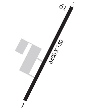
| 6400x150 | 6400' | 6400x150 | 6400' | 111.90 - 191° | ||||
| Runway ID | Single Wheel | Double Wheel | Double Tandem Wheel | Dual Double Wheel |
| 01/19 | 116,000 | 186,000 | 300,000 | 726,000 |
| These numbers are Advisory and are not limits. The Airport Manager should have more accurate Weight Limits | ||||
 Airport Diagram might not be current. | |
| Facility Name: | DILLINGHAM |
| City Name: | DILLINGHAM |
| County: | DILLINGHAM |
| State abbrev: | AK |
| State Name: | ALASKA |
| Ownership: | PUBLICLY OWNED |
| Use: | OPEN TO THE PUBLIC |
| Owner's Name: | ALASKA DOT&PF CENTRAL REGION |
| Address: | P O BOX 196900 |
| ANCHORAGE, AK 99519-6900 | |
| Owner's Phone: | 907-269-0749 |
| Manager's Name: | JON TAYLOR |
| Address: | BOX 250 |
| DILLINGHAM, AK 99576 | |
| Phone: | 907-842-5511 |
| FAA Region: | ALASKA |
| FAA Field Office: | NONE |
| Date | Sunrise | Sunset |
|---|---|---|
| 04/24/24 Wednesday | 6:52 | 22:13 |
| 04/25/24 Thursday | 6:50 | 22:15 |
| 04/26/24 Friday | 6:47 | 22:18 |
| 04/27/24 Saturday | 6:44 | 22:20 |
| 04/28/24 Sunday | 6:42 | 22:22 |
| 04/29/24 Monday | 6:39 | 22:25 |
| 04/30/24 Tuesday | 6:36 | 22:27 |
| 05/01/24 Wednesday | 6:34 | 22:29 |
| 05/02/24 Thursday | 6:31 | 22:32 |
| 05/03/24 Friday | 6:29 | 22:34 |
| 05/04/24 Saturday | 6:26 | 22:36 |
| 05/05/24 Sunday | 6:24 | 22:39 |
| 05/06/24 Monday | 6:21 | 22:41 |
| 05/07/24 Tuesday | 6:19 | 22:43 |
| Airport Attendance Schedule | 7 Days A Week 0700-1730; AFT HR ARPT/MAINT SVC, WILDLIFE CTL, SN REMOVAL, COND RPRTG PPR - AMGR. |
| Airport Status | OPERATIONAL (This Status can change at any time - please check NOTAMS) |
| Airport Lighting Schedule | WHEN DLG FSS CLSD ACTVT ODALS RWY 19; PAPI RWY 01; VASI RWY 19; HIRL RWY 01/19 - CTAF. |
| Airport Storage Available | Tie Downs |
| Extra Services Available | Cargo Handling |
| Wind Indicator | YES - (unlit) |
| Control Tower | NO |
| CTAF Frequency | 123.600 |
| Unicom Frequency | |
| Rotating Beacon Color | WG; ON TWR AT ARFF BLDG; OPS UNMNT WHEN DLG FSS CLSD. |
| Segmented Circle | YES |
| Landing Fee |
| Airport Inspected | FEDERAL - performed by FAA AIRPORTS FIELD PERSONNEL |
| Inspection Date | 05/20/2021 |
| Type of Fuel Available | Grade 100LL, JET A (freeze point -40C) |
| Airframe Repair Service | MINOR |
| Power Plant Repair Service | MINOR |
| Latitude | N5902.7 |
| Longitude | W15830.3 (ESTIMATED) |
| Arpt Elevation | 82ft (SURVEYED) |
| Magnetic Variation | 15E |
| 2 miles W | of DILLINGHAM |
| Traffic Pattern Altitude | |
| Sectional Chart | KODIAK |
| Operations (Reported) | Yearly | Avg. Daily |
|---|---|---|
| General Aviation Transient | 10986 | 30 |
| General Aviation Local | 2083 | 6 |
| Air Taxi | 36489 | 100 |
| Commerical | 1323 | 4 |
| Commuter | 0 | 0 |
| Military | 11 | 0 |
| Aircraft based on Field | |
|---|---|
| General Aviation Singles | 52 |
| General Aviation Multi | 6 |
| Jet Aircraft | 0 |
| General Aviation Helicopters | 1 |
| Military Aircraft | 0 |
| Gliders | 0 |
| Ultralights | 0 |
| FSS on field | YES |
| FSS tie-in | DILLINGHAM |
| FSS Phone | 842-5275 (Local call) |
| Nearby FSS | KENAI |
| Phone | 1-800-866-864-1737 |
| Who issues Notams | DLG |
| Notam D service at airport | YES |
| ARTCC Name | ANCHORAGE |
| Airport Certification | AIRPORT RECEIVING SCHEDULED AIR CARRIER SERVICE FROM CARRIERS CERTIFICATED BY THE CIVIL AERONAUTICS BOARD; CLSD TO ACR OPS MORE THAN 30 PAX SEATS EXC PPR IN WRITING - AMGR BOX 250 DILLINGHAM, AK 99576. |
| Aircraft Rescue & Firefighting Index | AIRPORT HAS A CERTIFICATE UNDER CFR PART 139 |
| Airport of Entry | No |
| Custom Landing Rights | No |
| Joint Civil/Military | No |
| Military Landing rights | YES |
| NATIONAL PLAN OF INTEGRATED AIRPORT SYSTEMS (NPIAS) |
| GRANT AGREEMENTS UNDER FAAP/ADAP/AIP |
| CONVEYANCE UNDER SCETION 16, FEDERAL AIRPORT ACT OF 1946 OR SECTION 23, AIRPORT AND AIRWAY DEVELOPMENT ACT OF 1970 |
| ASSURANCES PURSUANT TO TITLE VI, CIVIL RIGHTS ACT OF 1964 |
| FUEL - 907-842-1234/2400; AFT HR - 907-843-1590/907-252-7625. |
| LOCK WHEELED TURNS NA. |
| AWOS SW WIND READG UNRELBL. |
| TSA REGULATED ARPT; SEE 49 CFR 1542. GATES & DOORS MUST BE SECURED ALL TIMES. TSNT OR UNFAMILIAR PILOTS INFO - AMGR. |
| INCRD BIRD ACT SPRING & FALL. |
| PPR FOR HAZ RPRTG RWY, TWY OR RAMP SNOW CTL. |
| RWY SAFETY AREA S 3600 FT X 300 FT; N 3289 FT X 200 FT. |
| TWY, RAMP OR RSA TKOF OR LDG NA. |
| ARFF EQUIP AVBL DURG ACR ACT ONLY. |
| PAEW ON RWY PSBL ANY TIME. |
| TSNT PRKG MKD WITH GREEN CONES. |
| WX CAMERA AVBL ON INTERNET AT HTTPS://WEATHERCAMS.FAA.GOV/. |
| ARPT SAND LRGR GRADATION THAN FAA RCMDD/SEE AC150/5200-30. |
| RWY 01/1 9 LGTS 30 IN HIGH. |
Airport Communications & Frequencies:
| |||||||
| Runway: 01 | Runway: 19 | ||
| Mag heading: | 11° | Mag heading: | 191° |
| Rwy Slope: | -.15% Down | Rwy Slope: | .15% Up |
| Approach: | MLS | Approach: | LOC/DME |
| Pattern: | Left Traffic | Pattern: | Right Traffic |
| Markings: | NONPRECISION INSTRUMENT | Markings: | NONPRECISION INSTRUMENT |
| Marking Condition: | GOOD | Marking Condition: | GOOD |
| Arresting Dev: | Arresting Dev: | ||
| Lat & Long: | N5902.2 W15830.8 | Lat. & Long.: | N5903.2 W15829.9 |
| Elev: | 74.6 ft. MSL | Elev: | 65.0 ft. MSL |
| TCH: | 45 ft. AGL | TCH: | 57 ft. AGL |
| Visual Glide Path: | 3.00 degrees | Visual Glide Path: | 3.00 degrees |
| Displaced Threshold: | No | Displaced Threshold: | No |
| Touchdown Zone: | YES | Touchdown Zone: | YES |
| Touchdown Elev.: | 81.6 feet | Touchdown Elev.: | 81.4 feet |
| Visual Glide Slope: | 4-Light PAPI on LEFT side of Runway | Visual Glide Slope: | 4-BOX VASI ON LEFT SIDE OF RUNWAY |
| RVR Equipment: | RVR Equipment: | ||
| RVV Equipment: | NO | RVV Equipment: | NO |
| Approach Lights: | Approach Lights: | ODALS - omnidirectional approach lighting system | |
| REIL: | NO | REIL: | YES |
| Centerline Lights: | NO | Centerline Lights: | NO |
| Touchdown lights: | NO | Touchdown lights: | NO |
| Runway Category: | Runway with a Non-precision Approach having visibility minimums greater than 3/4 mile | Runway Category: | Runway with a Non-precision Approach having visibility minimums greater than 3/4 mile |
| Declared Distances: | TORA:6400' TODA:6400' ASDA:6400' LDA:6400' | Declared Distances: | TORA:6400' TODA:6400' ASDA:6400' LDA:6400' |
| Obstructions: | Obstructions: | TREES | |
| Marked: | Marked: | NOT Marked/Lighted | |
| Clearance slope: | 34:1 | Clearance slope: | 20:1 |
| Obstruction height: | Obstruction height: | 79 feet AGL | |
| Dist. from runway: | Dist. from runway: | 1789 feet | |
| Centerline offset: | Centerline offset: | 273 feet right of centerline | |
| Comments: | Comments: |