Current Weather/Notams (Metars, TAFs, Notams, NWS Forecast, PIREPS, and nearby weather)
Customs Information Send updates to Support@FltPlan.com
Customs Not Available
Database effective 04/18/2024
Airport Diagram might not be current.
|
| Facility Name: | DEERING |
| City Name: | DEERING |
| County: | NORTHWEST ARCTIC; NORTHWEST ARCTIC BOROUGH |
| State abbrev: | AK |
| State Name: | ALASKA |
| | |
| Ownership: | PUBLICLY OWNED |
| Use: | OPEN TO THE PUBLIC |
| Owner's Name: | ALASKA DOT&PF NORTHERN REGION |
| Address: | 2301 PEGER RD |
| | FAIRBANKS, AK 99709 |
| Owner's Phone: | 907-451-2200 |
| | |
| Manager's Name: | ALVIN WERNEKE |
| Address: | BOX 55 |
| | KOTZEBUE, AK 99752 |
| Phone: | 907-442-3147 |
| | |
| FAA Region: | ALASKA |
| FAA Field Office: | NONE |
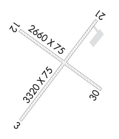
Runway Identifications
Runway Identification: 03/21Length: 3320 ft
Width: 75 ft
Surface: -GOOD CONDITION
Edge lights: Medium IntensityTreatment: NONE
| | Runway: 03 | | Runway: 21 |
| Mag heading: | 27° | Mag heading: | 207° |
| Rwy Slope: | -.08% Down | Rwy Slope: | .08% Up |
| Approach: | | Approach: | |
| Pattern: | Left Traffic | Pattern: | Left Traffic |
| Markings: | NONSTANDARD | Markings: | NONSTANDARD |
| Marking Condition: | RY 03/21 NSTD MKGS; MKD WITH LIGHTS AND PLASTIC MARKERS. | Marking Condition: | |
| Arresting Dev: | | Arresting Dev: | |
| Lat & Long: | N6603.9 W16246.4 | Lat. & Long.: | N6604.3 W16245.6 |
| Elev: | 22.6 ft. MSL | Elev: | 19.8 ft. MSL |
| TCH: | 25 ft. AGL | TCH: | |
| Visual Glide Path: | 3.00 degrees | Visual Glide Path: | |
| Displaced Threshold: | No | Displaced Threshold: | No |
| Touchdown Zone: | YES | Touchdown Zone: | YES |
| Touchdown Elev.: | 25.2 feet | Touchdown Elev.: | 25.2 feet |
| Visual Glide Slope: | 4-Light PAPI on RIGHT side of Runway | Visual Glide Slope: | |
| RVR Equipment: | | RVR Equipment: | |
| RVV Equipment: | NO | RVV Equipment: | NO |
| Approach Lights: | | Approach Lights: | |
| REIL: | YES | REIL: | NO |
| Centerline Lights: | NO | Centerline Lights: | NO |
| Touchdown lights: | NO | Touchdown lights: | NO |
| Runway Category: | Runway with a Non-precision Approach | Runway Category: | Runway with a Non-precision Approach |
| Declared Distances: | | Declared Distances: | |
Runway Identification: 12/30Length: 2660 ft
Width: 75 ft
Surface: -GOOD CONDITION
Edge lights: Medium IntensityTreatment: NONE
| | Runway: 12 | | Runway: 30 |
| Mag heading: | 115° | Mag heading: | 295° |
| Rwy Slope: | -.36% Down | Rwy Slope: | .36% Up |
| Approach: | | Approach: | |
| Pattern: | Left Traffic | Pattern: | Left Traffic |
| Markings: | NONSTANDARD | Markings: | NONSTANDARD |
| Marking Condition: | RY 12/30 NSTD MKGS; MKD WITH LIGHTS AND PLASTIC MARKERS. | Marking Condition: | |
| Arresting Dev: | | Arresting Dev: | |
| Lat & Long: | N6604.3 W16246.4 | Lat. & Long.: | N6604.0 W16245.6 |
| Elev: | 29.9 ft. MSL | Elev: | 20.4 ft. MSL |
| TCH: | | TCH: | |
| Visual Glide Path: | | Visual Glide Path: | |
| Displaced Threshold: | No | Displaced Threshold: | No |
| Touchdown Zone: | YES | Touchdown Zone: | YES |
| Touchdown Elev.: | 29.9 feet | Touchdown Elev.: | 29.9 feet |
| Visual Glide Slope: | | Visual Glide Slope: | |
| RVR Equipment: | | RVR Equipment: | |
| RVV Equipment: | NO | RVV Equipment: | NO |
| Approach Lights: | | Approach Lights: | |
| REIL: | NO | REIL: | NO |
| Centerline Lights: | NO | Centerline Lights: | NO |
| Touchdown lights: | NO | Touchdown lights: | NO |
| Runway Category: | Runway with a Non-precision Approach | Runway Category: | Runway with a Non-precision Approach |
| Declared Distances: | | Declared Distances: | |
