Approach Charts
| FltPlan does not have IFR approach charts available for PABV. |
Current Weather/Notams (Metars, TAFs, Notams, NWS Forecast, PIREPS, and nearby weather)
Customs Information Send updates to Support@FltPlan.com
Customs Not Available
Database effective 05/16/2024
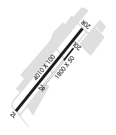
Airport Diagram might not be current.
|
| Facility Name: | BIRCHWOOD |
| City Name: | BIRCHWOOD |
| County: | ANCHORAGE |
| State abbrev: | AK |
| State Name: | ALASKA |
| | |
| Ownership: | PUBLICLY OWNED |
| Use: | OPEN TO THE PUBLIC |
| Owner's Name: | ALASKA DOT&PF CENTRAL REGION |
| Address: | PO BOX 196900 |
| | ANCHORAGE, AK 99519-6900 |
| Owner's Phone: | (907) 338-1466 |
| | |
| Manager's Name: | KAYCE ELIASON |
| Address: | 5300 E. TUDOR ROAD, STATE OF ALASKA DOTPF CR |
| | ANCHORAGE, AK 99507-1249 |
| Phone: | 907-338-1466 |
| | |
| FAA Region: | ALASKA |
| FAA Field Office: | NONE |
Runway Identifications
Runway Identification: 02L/20RLength: 4012 ft
Width: 100 ft
Surface: ASPHALT-FAIR CONDITION
Edge lights: Medium IntensityTreatment: NONE
| | Runway: 02L | | Runway: 20R |
| Mag heading: | 20° | Mag heading: | 200° |
| Rwy Slope: | -.35% Down | Rwy Slope: | .35% Up |
| Approach: | | Approach: | |
| Pattern: | Left Traffic | Pattern: | Right Traffic |
| Markings: | NONPRECISION INSTRUMENT | Markings: | NONPRECISION INSTRUMENT |
| Marking Condition: | FAIR | Marking Condition: | FAIR |
| Arresting Dev: | | Arresting Dev: | |
| Lat & Long: | N6124.7 W14931.0 | Lat. & Long.: | N6125.2 W14930.1 |
| Elev: | 82.6 ft. MSL | Elev: | 68.5 ft. MSL |
| TCH: | | TCH: | 48 ft. AGL |
| Visual Glide Path: | | Visual Glide Path: | |
| Displaced Threshold: | No | Displaced Threshold: | No |
| Touchdown Zone: | YES | Touchdown Zone: | YES |
| Touchdown Elev.: | 83.0 feet | Touchdown Elev.: | 82.0 feet |
| Visual Glide Slope: | | Visual Glide Slope: | 4-BOX VASI ON LEFT SIDE OF RUNWAY; KEY MIKE 7 TIMES FOR VASI. |
| RVR Equipment: | | RVR Equipment: | |
| RVV Equipment: | NO | RVV Equipment: | NO |
| Approach Lights: | | Approach Lights: | |
| REIL: | NO | REIL: | NO |
| Centerline Lights: | NO | Centerline Lights: | NO |
| Touchdown lights: | NO | Touchdown lights: | NO |
| Runway Category: | Runway with a Visual Approach | Runway Category: | Runway with a Visual Approach |
| Declared Distances: | | Declared Distances: | |
| Obstructions: | TREES | Obstructions: | TREES |
| Marked: | NOT Marked/Lighted | Marked: | NOT Marked/Lighted |
| Clearance slope: | 6:1 | Clearance slope: | 18:1 |
| Obstruction height: | 71 feet AGL | Obstruction height: | 44 feet AGL |
| Dist. from runway: | 613 feet | Dist. from runway: | 980 feet |
| Centerline offset: | 283 left of centerline | Centerline offset: | 308 feet right of centerline |
| Comments: | -5 FT FENCE 195 FT FM PAVEMENT EDGE. | Comments: | |
Runway Identification: 02R/20LLength: 1802 ft
Width: 50 ft
Surface: ASPHALT-GOOD CONDITION-FAIR CONDITION
Edge lights: Treatment: NONE
| | Runway: 02R | | Runway: 20L |
| Mag heading: | 20° | Mag heading: | 200° |
| Rwy Slope: | -.31% Down | Rwy Slope: | .31% Up |
| Approach: | | Approach: | |
| Pattern: | Left Traffic | Pattern: | Right Traffic |
| Markings: | | Markings: | |
| Marking Condition: | | Marking Condition: | |
| Arresting Dev: | | Arresting Dev: | |
| Lat & Long: | N6124.9 W14930.6 | Lat. & Long.: | N6125.1 W14930.2 |
| Elev: | 78.6 ft. MSL | Elev: | 73.0 ft. MSL |
| TCH: | | TCH: | |
| Visual Glide Path: | | Visual Glide Path: | |
| Displaced Threshold: | No | Displaced Threshold: | No |
| Touchdown Zone: | YES | Touchdown Zone: | YES |
| Touchdown Elev.: | 79.3 feet | Touchdown Elev.: | 79.3 feet |
| Visual Glide Slope: | | Visual Glide Slope: | |
| RVR Equipment: | | RVR Equipment: | |
| RVV Equipment: | NO | RVV Equipment: | NO |
| Approach Lights: | | Approach Lights: | |
| REIL: | NO | REIL: | NO |
| Centerline Lights: | NO | Centerline Lights: | NO |
| Touchdown lights: | NO | Touchdown lights: | NO |
| Runway Category: | Runway with a Visual Approach | Runway Category: | Runway with a Visual Approach |
| Declared Distances: | | Declared Distances: | |
