Current Weather/Notams (Metars, TAFs, Notams, NWS Forecast, PIREPS, and nearby weather)
Customs Information Send updates to Support@FltPlan.com
Customs Not Available
Database effective 04/18/2024
Airport Diagram might not be current.
|
| Facility Name: | ALLEN AAF |
| City Name: | DELTA JUNCTION FT GREELY |
| County: | FAIRBANKS NORTH STAR |
| State abbrev: | AK |
| State Name: | ALASKA |
| | |
| Ownership: | ARMY OWNED |
| Use: | PRIVATE |
| Owner's Name: | U.S. ARMY |
| Address: | U.S. ARMY FORCES COMMAND |
| | ATLANTA, GA |
| Owner's Phone: | |
| | |
| Manager's Name: | HQ 172 INFANTRY BRIGADE |
| Address: | FT RICHARDSON |
| | ALASKA 99505 |
| Phone: | 907-873-7400 |
| | |
| FAA Region: | ALASKA |
| FAA Field Office: | NONE |
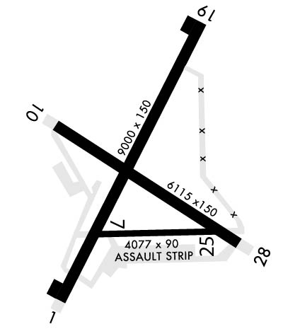
Runway Identifications
Runway Identification: 01/19Length: 9000 ft
Width: 150 ft
Surface: ASPHALT-GOOD CONDITION
Edge lights: High IntensityTreatment: NONE
Weight: PCN 42 /F/A/W/T
| | Runway: 01 | | Runway: 19 |
| Mag heading: | 7° | Mag heading: | 187° |
| Rwy Slope: | -.73% Down | Rwy Slope: | .73% Up |
| Approach: | | Approach: | |
| Pattern: | Left Traffic | Pattern: | Right Traffic |
| Markings: | NONPRECISION INSTRUMENT | Markings: | NONPRECISION INSTRUMENT |
| Marking Condition: | GOOD | Marking Condition: | GOOD |
| Arresting Dev: | | Arresting Dev: | |
| Lat & Long: | N6359.2 W14544.1 | Lat. & Long.: | N6400.5 W14542.4 |
| Elev: | 1285.2 ft. MSL | Elev: | 1219.6 ft. MSL |
| TCH: | 74 ft. AGL | TCH: | 74 ft. AGL |
| Visual Glide Path: | 3.00 degrees | Visual Glide Path: | 3.00 degrees |
| Displaced Threshold: | 1000 feet | Displaced Threshold: | 1088 feet |
| Touchdown Zone: | YES | Touchdown Zone: | YES |
| Touchdown Elev.: | 1285.2 feet | Touchdown Elev.: | 1238.9 feet |
| Visual Glide Slope: | 4-Light PAPI on LEFT side of Runway | Visual Glide Slope: | 4-Light PAPI on LEFT side of Runway |
| RVR Equipment: | | RVR Equipment: | |
| RVV Equipment: | NO | RVV Equipment: | NO |
| Approach Lights: | | Approach Lights: | |
| REIL: | NO | REIL: | NO |
| Centerline Lights: | NO | Centerline Lights: | NO |
| Touchdown lights: | NO | Touchdown lights: | NO |
| Runway Category: | Runway with a Visual Approach | Runway Category: | Runway with a Visual Approach |
| Declared Distances: | | Declared Distances: | |
Runway Identification: 07/25Length: 4057 ft
Width: 88 ft
Surface: ASPHALT-GOOD CONDITION
Edge lights: Medium IntensityTreatment: NONE
Weight: PCN 42 /F/A/W/T
| | Runway: 07 | | Runway: 25 |
| Mag heading: | 69° | Mag heading: | 249° |
| Rwy Slope: | -.27% Down | Rwy Slope: | .27% Up |
| Approach: | | Approach: | |
| Pattern: | Left Traffic | Pattern: | Right Traffic |
| Markings: | NONPRECISION INSTRUMENT | Markings: | NONPRECISION INSTRUMENT |
| Marking Condition: | GOOD | Marking Condition: | GOOD |
| Arresting Dev: | | Arresting Dev: | |
| Lat & Long: | N6359.5 W14543.8 | Lat. & Long.: | N6359.5 W14542.3 |
| Elev: | 1267.9 ft. MSL | Elev: | 1257.1 ft. MSL |
| TCH: | | TCH: | |
| Visual Glide Path: | | Visual Glide Path: | |
| Displaced Threshold: | No | Displaced Threshold: | No |
| Touchdown Zone: | YES | Touchdown Zone: | YES |
| Touchdown Elev.: | 1267.9 feet | Touchdown Elev.: | 1263.8 feet |
| Visual Glide Slope: | | Visual Glide Slope: | |
| RVR Equipment: | | RVR Equipment: | |
| RVV Equipment: | NO | RVV Equipment: | NO |
| Approach Lights: | | Approach Lights: | |
| REIL: | NO | REIL: | NO |
| Centerline Lights: | NO | Centerline Lights: | NO |
| Touchdown lights: | NO | Touchdown lights: | NO |
| Runway Category: | Runway with a Visual Approach | Runway Category: | Runway with a Visual Approach |
| Declared Distances: | | Declared Distances: | |
Runway Identification: 10/28Length: 6115 ft
Width: 150 ft
Surface: ASPHALT-GOOD CONDITION
Edge lights: High IntensityTreatment: NONE
Weight: PCN 87 /F/A/W/T
| | Runway: 10 | | Runway: 28 |
| Mag heading: | 102° | Mag heading: | 282° |
| Rwy Slope: | .04% Up | Rwy Slope: | -.04% Down |
| Approach: | ILS/DME | Approach: | |
| Pattern: | Left Traffic | Pattern: | Left Traffic |
| Markings: | PRECISION INSTRUMENT | Markings: | PRECISION INSTRUMENT |
| Marking Condition: | GOOD | Marking Condition: | GOOD |
| Arresting Dev: | | Arresting Dev: | |
| Lat & Long: | N6400.0 W14544.1 | Lat. & Long.: | N6359.4 W14542.2 |
| Elev: | 1253.8 ft. MSL | Elev: | 1256.3 ft. MSL |
| TCH: | 76 ft. AGL | TCH: | 74 ft. AGL |
| Visual Glide Path: | 3.00 degrees | Visual Glide Path: | 3.00 degrees |
| Displaced Threshold: | No | Displaced Threshold: | No |
| Touchdown Zone: | YES | Touchdown Zone: | YES |
| Touchdown Elev.: | 1252.6 feet | Touchdown Elev.: | 1257.7 feet |
| Visual Glide Slope: | 4-Light PAPI on LEFT side of Runway | Visual Glide Slope: | 4-Light PAPI on LEFT side of Runway |
| RVR Equipment: | | RVR Equipment: | |
| RVV Equipment: | NO | RVV Equipment: | NO |
| Approach Lights: | | Approach Lights: | |
| REIL: | YES | REIL: | YES |
| Centerline Lights: | NO | Centerline Lights: | NO |
| Touchdown lights: | NO | Touchdown lights: | NO |
| Runway Category: | Runway with a Visual Approach | Runway Category: | Runway with a Visual Approach |
| Declared Distances: | | Declared Distances: | |
