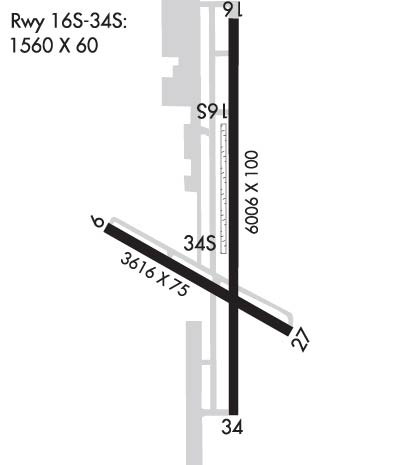
Runway Identification: 10/28Length: 3616 ft
Width: 75 ft
Surface: ASPHALT-GOOD CONDITION
Edge lights: Medium IntensityTreatment: NONE
Weight: PCN 7 /R/B/X/U
| | Runway: 10 | | Runway: 28 |
| Mag heading: | 97° | Mag heading: | 277° |
| Rwy Slope: | -.16% Down | Rwy Slope: | .16% Up |
| Approach: | | Approach: | |
| Pattern: | Left Traffic | Pattern: | Left Traffic |
| Markings: | BASIC | Markings: | BASIC |
| Marking Condition: | FAIR | Marking Condition: | FAIR |
| Arresting Dev: | | Arresting Dev: | |
| Lat & Long: | N6135.7 W14906.0 | Lat. & Long.: | N6135.5 W14904.9 |
| Elev: | 233.4 ft. MSL | Elev: | 227.6 ft. MSL |
| TCH: | 27 ft. AGL | TCH: | 26 ft. AGL |
| Visual Glide Path: | 3.00 degrees | Visual Glide Path: | 3.00 degrees |
| Displaced Threshold: | No | Displaced Threshold: | No |
| Touchdown Zone: | YES | Touchdown Zone: | YES |
| Touchdown Elev.: | 233.4 feet | Touchdown Elev.: | 232.4 feet |
| Visual Glide Slope: | 2-Light PAPI on LEFT side of Runway | Visual Glide Slope: | 2-Light PAPI on LEFT side of Runway; PAPI RWY 28 UNUSBL BYD 3.0 NM; DOES NOT PRVD OBSTN CLNC BYD 3.0 NM FM THR. |
| RVR Equipment: | | RVR Equipment: | |
| RVV Equipment: | NO | RVV Equipment: | NO |
| Approach Lights: | | Approach Lights: | |
| REIL: | NO | REIL: | NO |
| Centerline Lights: | NO | Centerline Lights: | NO |
| Touchdown lights: | NO | Touchdown lights: | NO |
| Runway Category: | Runway with a Non-precision Approach having visibility minimums greater than 3/4 mile | Runway Category: | Runway with a Visual Approach |
| Declared Distances: | | Declared Distances: | |
| Obstructions: | TREES | Obstructions: | TOWER |
| Marked: | MARKED and LIGHTED | Marked: | NOT Marked/Lighted |
| Clearance slope: | 8:1 | Clearance slope: | 8:1 |
| Obstruction height: | 77 feet AGL | Obstruction height: | 54 feet AGL |
| Dist. from runway: | 860 feet | Dist. from runway: | 684 feet |
| Centerline offset: | 314 left of centerline | Centerline offset: | 247 feet right of centerline |
| Comments: | | Comments: | |
Runway Identification: 16/34Length: 6006 ft
Width: 100 ft
Surface: ASPHALT-GOOD CONDITION
Edge lights: Medium IntensityTreatment: NONE
Weight: PCN 34 /F/B/X/U
| | Runway: 16 | | Runway: 34 |
| Mag heading: | 164° | Mag heading: | 344° |
| Rwy Slope: | -.46% Down | Rwy Slope: | .46% Up |
| Approach: | | Approach: | |
| Pattern: | Left Traffic | Pattern: | Left Traffic |
| Markings: | BASIC | Markings: | BASIC |
| Marking Condition: | FAIR | Marking Condition: | FAIR |
| Arresting Dev: | | Arresting Dev: | |
| Lat & Long: | N6136.2 W14905.3 | Lat. & Long.: | N6135.3 W14905.2 |
| Elev: | 248.6 ft. MSL | Elev: | 220.8 ft. MSL |
| TCH: | 43 ft. AGL | TCH: | 52 ft. AGL |
| Visual Glide Path: | 3.00 degrees | Visual Glide Path: | 3.00 degrees |
| Displaced Threshold: | 503 feet | Displaced Threshold: | No |
| Touchdown Zone: | YES | Touchdown Zone: | YES |
| Touchdown Elev.: | 246.5 feet | Touchdown Elev.: | 235.8 feet |
| Visual Glide Slope: | 4-Light PAPI on LEFT side of Runway | Visual Glide Slope: | 4-Light PAPI on LEFT side of Runway; PAPI RWY 34 UNUSBL BYD 5.4 NM; DOES NOT PRVD OBSTN CLNC BYD 5.4 NM FM THR. |
| RVR Equipment: | | RVR Equipment: | |
| RVV Equipment: | NO | RVV Equipment: | NO |
| Approach Lights: | | Approach Lights: | |
| REIL: | YES | REIL: | YES |
| Centerline Lights: | NO | Centerline Lights: | NO |
| Touchdown lights: | NO | Touchdown lights: | NO |
| Runway Category: | Runway with a Visual Approach | Runway Category: | Runway with a Visual Approach |
| Declared Distances: | TORA:6008' TODA:6008' ASDA:6008' LDA:5508' | Declared Distances: | TORA:6008' TODA:6008' ASDA:6008' LDA:6008' |
| Obstructions: | TREES | Obstructions: | HILL |
| Marked: | NOT Marked/Lighted | Marked: | NOT Marked/Lighted |
| Clearance slope: | 11:1 | Clearance slope: | 22:1 |
| Obstruction height: | 79 feet AGL | Obstruction height: | 42 feet AGL |
| Dist. from runway: | 1123 feet | Dist. from runway: | 1161 feet |
| Centerline offset: | 337 right of centerline | Centerline offset: | 162 feet right of centerline |
| Comments: | | Comments: | |
Runway Identification: 16S/34SLength: 1560 ft
Width: 60 ft
Surface: -GOOD CONDITION
Edge lights: Treatment: NONE
| | Runway: 16S | | Runway: 34S |
| Mag heading: | 164° | Mag heading: | 344° |
| Rwy Slope: | -.48% Down | Rwy Slope: | .48% Up |
| Approach: | | Approach: | |
| Pattern: | Left Traffic | Pattern: | Left Traffic |
| Markings: | | Markings: | |
| Marking Condition: | | Marking Condition: | |
| Arresting Dev: | | Arresting Dev: | |
| Lat & Long: | N6135.9 W14905.3 | Lat. & Long.: | N6135.6 W14905.3 |
| Elev: | 238.5 ft. MSL | Elev: | 231.0 ft. MSL |
| TCH: | | TCH: | |
| Visual Glide Path: | | Visual Glide Path: | |
| Displaced Threshold: | No | Displaced Threshold: | No |
| Touchdown Zone: | NO | Touchdown Zone: | NO |
| Touchdown Elev.: | | Touchdown Elev.: | |
| Visual Glide Slope: | | Visual Glide Slope: | |
| RVR Equipment: | | RVR Equipment: | |
| RVV Equipment: | NO | RVV Equipment: | NO |
| Approach Lights: | | Approach Lights: | |
| REIL: | NO | REIL: | NO |
| Centerline Lights: | NO | Centerline Lights: | NO |
| Touchdown lights: | NO | Touchdown lights: | NO |
| Runway Category: | Runway with a Visual Approach | Runway Category: | Runway with a Visual Approach |
| Declared Distances: | | Declared Distances: | |
Runway Identification: H1 HELIPADLength: 50 ft
Width: 50 ft
Surface: ASPHALT-FAIR CONDITION
Edge lights:
Treatment: NONE