
| ||||||||||||||||||||||||||||||||
| ||||||||||||||||||||||||||||||||
| ||||||||||||||||||||||||||||||||
| Rwy | Rwy | |||||||
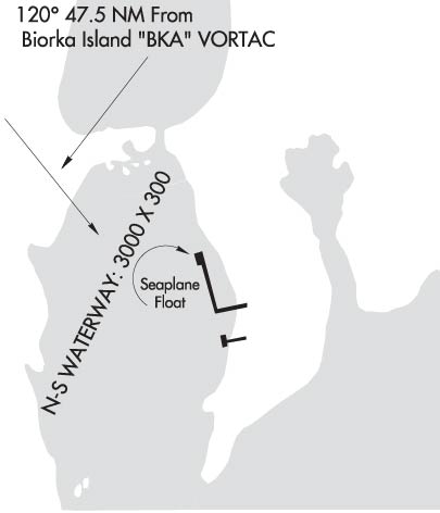
| 3000x300 | 3000' | 3000x300 | 3000' | |||||
| Runway ID | Single Wheel | Double Wheel | Double Tandem Wheel | Dual Double Wheel |
| N/S | N/A | N/A | N/A | N/A |
| These numbers are Advisory and are not limits. The Airport Manager should have more accurate Weight Limits | ||||
| FltPlan does not have IFR approach charts available for PAAP. |
 Airport Diagram might not be current. | |
| Facility Name: | PORT ALEXANDER |
| City Name: | PORT ALEXANDER |
| County: | PRINCE OF WALES |
| State abbrev: | AK |
| State Name: | ALASKA |
| Ownership: | PUBLICLY OWNED |
| Use: | OPEN TO THE PUBLIC |
| Owner's Name: | ALASKA DOT&PF SOUTHCOAST REGION |
| Address: | 6860 GLACIER HWY |
| JUNEAU, AK 99801-7999 | |
| Owner's Phone: | (907) 465-4512 |
| Manager's Name: | STEVE BELL |
| Address: | P.O. BOX 112506 |
| JUNEAU, AK 99811 | |
| Phone: | (907) 465-4512 |
| FAA Region: | ALASKA |
| FAA Field Office: | NONE |
| Date | Sunrise | Sunset |
|---|---|---|
| 04/23/24 Tuesday | 5:30 | 20:25 |
| 04/24/24 Wednesday | 5:28 | 20:27 |
| 04/25/24 Thursday | 5:25 | 20:29 |
| 04/26/24 Friday | 5:23 | 20:31 |
| 04/27/24 Saturday | 5:21 | 20:33 |
| 04/28/24 Sunday | 5:18 | 20:35 |
| 04/29/24 Monday | 5:16 | 20:37 |
| 04/30/24 Tuesday | 5:14 | 20:39 |
| 05/01/24 Wednesday | 5:11 | 20:41 |
| 05/02/24 Thursday | 5:09 | 20:43 |
| 05/03/24 Friday | 5:07 | 20:45 |
| 05/04/24 Saturday | 5:05 | 20:47 |
| 05/05/24 Sunday | 5:03 | 20:49 |
| 05/06/24 Monday | 5:00 | 20:51 |
| Airport Attendance Schedule | UNATTENDED |
| Airport Status | OPERATIONAL (This Status can change at any time - please check NOTAMS) |
| Airport Lighting Schedule | |
| Airport Storage Available | NONE |
| Extra Services Available | NONE |
| Wind Indicator | YES - (unlit) |
| Control Tower | NO |
| CTAF Frequency | 122.900 |
| Unicom Frequency | |
| Rotating Beacon Color | |
| Segmented Circle | NO |
| Landing Fee | NO |
| Airport Inspected | STATE - performed by PRIVATE CONTRACT PERSONNEL |
| Inspection Date | 07/29/2021 |
| Type of Fuel Available | None |
| Airframe Repair Service | NONE |
| Power Plant Repair Service | NONE |
| Latitude | N5614.8 |
| Longitude | W13438.9 (ESTIMATED) |
| Arpt Elevation | 0ft (ESTIMATED) |
| Magnetic Variation | 26E |
| 0 miles NE | of PORT ALEXANDER |
| Traffic Pattern Altitude | |
| Sectional Chart | JUNEAU |
| Operations (Reported) | Yearly | Avg. Daily |
|---|---|---|
| General Aviation Transient | 75 | 0 |
| General Aviation Local | 0 | 0 |
| Air Taxi | 250 | 1 |
| Commerical | 0 | 0 |
| Commuter | 0 | 0 |
| Military | 0 | 0 |
| Aircraft based on Field | |
|---|---|
| General Aviation Singles | 0 |
| General Aviation Multi | 0 |
| Jet Aircraft | 0 |
| General Aviation Helicopters | 0 |
| Military Aircraft | 0 |
| Gliders | 0 |
| Ultralights | 0 |
| FSS on field | NO |
| FSS tie-in | SITKA |
| FSS Phone | 1-800-800-478-6300 |
| Nearby FSS | JUNEAU |
| Phone | 1-800-866-297-2236 |
| Who issues Notams | AHP |
| Notam D service at airport | YES |
| ARTCC Name | ANCHORAGE |
| Airport Certification | |
| Aircraft Rescue & Firefighting Index | None |
| Airport of Entry | No |
| Custom Landing Rights | No |
| Joint Civil/Military | No |
| Military Landing rights | YES |
| NATIONAL PLAN OF INTEGRATED AIRPORT SYSTEMS (NPIAS) |
| GRANT AGREEMENT HAS EXPIRED; HOWEVER, AGREEMENT REMAINS IN EFFECT FOR THIS FACILITY AS LONG AS IT IS PUBLIC USE. |
| WATCH FOR LOGS IN LNDG AREA. |
| BOATS MAY BE TIED TO SPB FLOAT. |
| WHEN AVBL WX RPRTS EVERY TWO HOURS. |
| WX CAMERA AVBL ON INTERNET AT HTTPS://WEATHERCAMS.FAA.GOV |
| Runway: N | Runway: S | ||
| Mag heading: | N/A | Mag heading: | N/A |
| Rwy Slope: | .00% | Rwy Slope: | .00% |
| Approach: | Approach: | ||
| Pattern: | Left Traffic | Pattern: | Left Traffic |
| Markings: | Markings: | ||
| Marking Condition: | Marking Condition: | ||
| Arresting Dev: | Arresting Dev: | ||
| Lat & Long: | Lat. & Long.: | ||
| Elev: | 0.0 ft. MSL | Elev: | 0.0 ft. MSL |
| TCH: | TCH: | ||
| Visual Glide Path: | Visual Glide Path: | ||
| Displaced Threshold: | No | Displaced Threshold: | No |
| Touchdown Zone: | NO | Touchdown Zone: | NO |
| Touchdown Elev.: | Touchdown Elev.: | ||
| Visual Glide Slope: | Visual Glide Slope: | ||
| RVR Equipment: | RVR Equipment: | ||
| RVV Equipment: | NO | RVV Equipment: | NO |
| Approach Lights: | Approach Lights: | ||
| REIL: | NO | REIL: | NO |
| Centerline Lights: | NO | Centerline Lights: | NO |
| Touchdown lights: | NO | Touchdown lights: | NO |
| Runway Category: | Runway Category: | ||
| Declared Distances: | Declared Distances: |