
| ||||||||||||||||||||||||||||||||
| ||||||||||||||||||||||||||||||||
| ||||||||||||||||||||||||||||||||
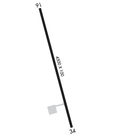
| Rwy | Rwy | |||||||
| 4500x100 | 4500' | 4500x100 | 4500' | |||||
| Runway ID | Single Wheel | Double Wheel | Double Tandem Wheel | Dual Double Wheel |
| 16/34 | 30,000 | 150,000 | N/A | N/A |
| These numbers are Advisory and are not limits. The Airport Manager should have more accurate Weight Limits | ||||
 Airport Diagram might not be current. | |
| Facility Name: | ATKA |
| City Name: | ATKA |
| County: | ALEUTIANS WEST |
| State abbrev: | AK |
| State Name: | ALASKA |
| Ownership: | PUBLICLY OWNED |
| Use: | OPEN TO THE PUBLIC |
| Owner's Name: | ALASKA DOT&PF SOUTHCOAST REGION |
| Address: | PO BOX 112506 |
| JUNEAU, AK 99811-2506 | |
| Owner's Phone: | (907) 465-1779 |
| Manager's Name: | DALE RUCKMAN |
| Address: | PO BOX 920525 |
| UNALASKA, AK 99692-0525 | |
| Phone: | 907-581-1786 |
| FAA Region: | ALASKA |
| FAA Field Office: | NONE |
| Date | Sunrise | Sunset |
|---|---|---|
| 04/24/24 Wednesday | 6:18 | 20:52 |
| 04/25/24 Thursday | 6:16 | 20:54 |
| 04/26/24 Friday | 6:14 | 20:56 |
| 04/27/24 Saturday | 6:12 | 20:57 |
| 04/28/24 Sunday | 6:10 | 20:59 |
| 04/29/24 Monday | 6:08 | 21:01 |
| 04/30/24 Tuesday | 6:06 | 21:03 |
| 05/01/24 Wednesday | 6:04 | 21:04 |
| 05/02/24 Thursday | 6:02 | 21:06 |
| 05/03/24 Friday | 6:01 | 21:08 |
| 05/04/24 Saturday | 5:59 | 21:09 |
| 05/05/24 Sunday | 5:57 | 21:11 |
| 05/06/24 Monday | 5:55 | 21:13 |
| 05/07/24 Tuesday | 5:53 | 21:14 |
| Airport Attendance Schedule | UNATTENDED |
| Airport Status | OPERATIONAL (This Status can change at any time - please check NOTAMS) |
| Airport Lighting Schedule | SS-SR |
| Airport Storage Available | NONE |
| Extra Services Available | NONE |
| Wind Indicator | YES - (lighted) |
| Control Tower | NO |
| CTAF Frequency | 122.900 |
| Unicom Frequency | |
| Rotating Beacon Color | WG |
| Segmented Circle | YES |
| Landing Fee | NO |
| Airport Inspected | STATE - performed by PRIVATE CONTRACT PERSONNEL |
| Inspection Date | 10/11/2022 |
| Type of Fuel Available | None |
| Airframe Repair Service | None |
| Power Plant Repair Service | None |
| Latitude | N5213.2 |
| Longitude | W17412.4 (ESTIMATED) |
| Arpt Elevation | 55ft (SURVEYED) |
| Magnetic Variation | 08E |
| 2 miles N | of ATKA |
| Traffic Pattern Altitude | |
| Sectional Chart | W ALEUTIAN ISLS |
| Operations (Reported) | Yearly | Avg. Daily |
|---|---|---|
| General Aviation Transient | 0 | 0 |
| General Aviation Local | 0 | 0 |
| Air Taxi | 0 | 0 |
| Commerical | 312 | 1 |
| Commuter | 0 | 0 |
| Military | 0 | 0 |
| Aircraft based on Field | |
|---|---|
| General Aviation Singles | 0 |
| General Aviation Multi | 0 |
| Jet Aircraft | 0 |
| General Aviation Helicopters | 0 |
| Military Aircraft | 0 |
| Gliders | 0 |
| Ultralights | 0 |
| FSS on field | NO |
| FSS tie-in | COLD BAY |
| FSS Phone | 1-800-800-478-7250 |
| Nearby FSS | KENAI |
| Phone | 1-800-866-864-1737 |
| Who issues Notams | AKA |
| Notam D service at airport | YES |
| ARTCC Name | ANCHORAGE |
| Airport Certification | |
| Aircraft Rescue & Firefighting Index | None |
| Airport of Entry | No |
| Custom Landing Rights | No |
| Joint Civil/Military | No |
| Military Landing rights | YES |
| NATIONAL PLAN OF INTEGRATED AIRPORT SYSTEMS (NPIAS) |
| GRANT AGREEMENTS UNDER FAAP/ADAP/AIP |
| ASSURANCES PURSUANT TO TITLE VI, CIVIL RIGHTS ACT OF 1964 |
| RWY COND NOT MNT; RCMD VISUAL INSP PRIOR TO USE. |
| GULLS & EAGLES ALG NAZAN BAY SHORELINE. |
| GCO AVBL ON FREQ 122.15 NSTD 4 CLICKS FOR KENAI FSS. |
| RWY MAINT & SNOW REMOVAL - 907-839-2319. |
| RWY 16/3 4 WASH OUT E SIDE OUTSIDE OF LGTS. |
| RWY 16 SAFETY AREA 150 PAVED & 150 FT GRVL. |
| RWY 34 SAFETY AREA 150 PAVED & 150 FT GRVL. |
Airport Communications & Frequencies:
| |||||||
| Runway: 16 | Runway: 34 | ||
| Mag heading: | 157° | Mag heading: | 337° |
| Rwy Slope: | -.50% Down | Rwy Slope: | .50% Up |
| Approach: | Approach: | ||
| Pattern: | Left Traffic | Pattern: | Left Traffic |
| Markings: | NONPRECISION INSTRUMENT | Markings: | NONPRECISION INSTRUMENT |
| Marking Condition: | POOR; WORN | Marking Condition: | POOR; WORN |
| Arresting Dev: | Arresting Dev: | ||
| Lat & Long: | N5213.6 W17412.5 | Lat. & Long.: | N5212.9 W17412.2 |
| Elev: | 55.2 ft. MSL | Elev: | 32.8 ft. MSL |
| TCH: | TCH: | ||
| Visual Glide Path: | Visual Glide Path: | ||
| Displaced Threshold: | No | Displaced Threshold: | No |
| Touchdown Zone: | YES | Touchdown Zone: | YES |
| Touchdown Elev.: | 55.2 feet | Touchdown Elev.: | 43.6 feet |
| Visual Glide Slope: | Visual Glide Slope: | ||
| RVR Equipment: | RVR Equipment: | ||
| RVV Equipment: | NO | RVV Equipment: | NO |
| Approach Lights: | Approach Lights: | ||
| REIL: | YES | REIL: | YES |
| Centerline Lights: | NO | Centerline Lights: | NO |
| Touchdown lights: | NO | Touchdown lights: | NO |
| Runway Category: | Runway with a Visual Approach | Runway Category: | Runway with a Visual Approach |
| Declared Distances: | Declared Distances: | ||
| Obstructions: | ROAD | Obstructions: | ROAD |
| Marked: | NOT Marked/Lighted | Marked: | NOT Marked/Lighted |
| Clearance slope: | 1:1 | Clearance slope: | 1:1 |
| Obstruction height: | 15 feet AGL | Obstruction height: | 15 feet AGL |
| Dist. from runway: | 813 feet | Dist. from runway: | 200 feet |
| Centerline offset: | Centerline offset: | 60 feet left of centerline | |
| Comments: | Comments: |