NOTICE: Information listed below may not be current.Airport Ident: MMTM
| Airport Name: GENERAL FRANCISCO JAVIER MINA INTL, Mexico
Location: Tampico
Latitude: N2217.8 Longitude: W09752.0
Field Elevation: 80' Variation: E5° as of 01/06
Time Zone: UTC-6(-5DT)
Daylight Savings: First Sunday in April to the last Saturday in October
Customs: Airport Of Entry
|
|
| DISTANCE from: | KTEB to MMTM = 1640 nm
| KMIA to MMTM = 985 nm
| KORD to MMTM = 1283 nm
| KDAL to MMTM = 636 nm
| KSEA to MMTM = 1914 nm
| KLAX to MMTM = 1289 nm
|
|
| AIRPORT TYPE: | | Active civil airports controlled and operated by civil authorities primarily for use by civil aircraft, although military may have landing privileges and/or contract rights. Minimum facilities are available which include: control tower (or some similar control system, such as a Flight Service Station which issues clearances and advisories when there is no tower or the tower is not in operation), lighting (may be flare pots, etc.), petrol, oils and lubricants (POL), and facilities for organizational maintenance or better. |
|
Rotating Beacon: YES
|
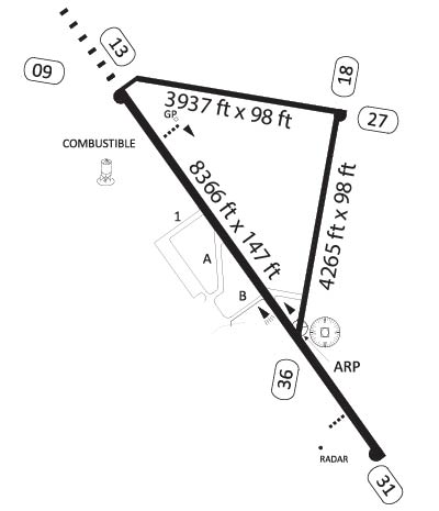
| RUNWAY INFORMATION: | Runway Ident: 27 /09
Runway Length: 3937
Runway Width: 98
Runway Surface: ASPHALT, ASPHALTIC CONCRETE, TAR MACADAM, OR BITUMEN BOUND MACADAM (INCLUDING ANY OF THESE SURFACE TYPES WITH CONCRETE ENDS).
Runway PCN Rating: -
Runway PCN Evaluation Method: N/A
Runway Open: YES
| Runway 27 Information
Runway True Heading: 280°
Takeoff Distance Available: 3937
Landing Distance Available: 3937
Runway Latitude: N2218.0
Runway Longitude: W09751.7
Runway Elevation:
Runway Slope: N/A
Runway TDZE:
Runway Lighting:
| Runway 09 Information
Runway True Heading: 100°
Takeoff Distance Available: 3937
Landing Distance Available: 3937
Runway Latitude: N2218.1
Runway Longitude: W09752.4
Runway Elevation:
Runway Slope: N/A
Runway TDZE: N/A
Runway Lighting:
|
Runway Ident: 31 /13
Runway Length: 8366
Runway Width: 148
Runway Surface: ASPHALT, ASPHALTIC CONCRETE, TAR MACADAM, OR BITUMEN BOUND MACADAM (INCLUDING ANY OF THESE SURFACE TYPES WITH CONCRETE ENDS).
Runway PCN Rating: 048FBXT - Flexible, Subgrade-MEDIUM, Tire Pressure-MEDIUM LIMITED TO 217 PSI
Runway PCN Evaluation Method: Technical Evaluation.
Runway Open: YES
| Runway 31 Information
Runway True Heading: 325°
Takeoff Distance Available: 8366
Landing Distance Available: 8366
Runway Latitude: N2217.0
Runway Longitude: W09751.6
Runway Elevation:
Runway Slope: N/A
Runway TDZE: 74'
Runway Lighting:
| Runway 13 Information
Runway True Heading: 145°
Takeoff Distance Available: 8410
Landing Distance Available: 8366
Runway Latitude: N2218.1
Runway Longitude: W09752.4
Runway Elevation:
Runway Slope: N/A
Runway TDZE: 79
Runway Lighting:
|
Runway Ident: 36 /18
Runway Length: 4265
Runway Width: 98
Runway Surface: ASPHALT, ASPHALTIC CONCRETE, TAR MACADAM, OR BITUMEN BOUND MACADAM (INCLUDING ANY OF THESE SURFACE TYPES WITH CONCRETE ENDS).
Runway PCN Rating: -
Runway PCN Evaluation Method: N/A
Runway Open: YES
| Runway 36 Information
Runway True Heading: 10°
Takeoff Distance Available: 4265
Landing Distance Available: 4265
Runway Latitude: N2217.4
Runway Longitude: W09751.9
Runway Elevation:
Runway Slope: N/A
Runway TDZE:
Runway Lighting:
| Runway 18 Information
Runway True Heading: 190°
Takeoff Distance Available: 4265
Landing Distance Available: 4265
Runway Latitude: N2218.0
Runway Longitude: W09751.7
Runway Elevation:
Runway Slope: N/A
Runway TDZE: N/A
Runway Lighting:
|
|
|
| ILS INFORMATION | Rwy 13 ILS Information
DME
Glide Slope (3°)
Localizer (109.3)
|
|
COMMUNICATION INFORMATION
APPROACH CONTROL - TAMPICO APP
120.3
TOWER - TAMPICO TWR
118.3
|
INSTRUMENT APPROACHES
VORDME 1 RW31
|
APPROACH MINIMUMS
VORDME 1 RW31 CIRCL Approach Minimums
Category A: 680' MSL and 1600 METERS
Category B: 680' MSL and 1600 METERS
Category C: 680' MSL and 2400 METERS
Category D: 680' MSL and 3200 METERS
Category E: NA
VORDME 1 RW31 S-31 Approach Minimums
Category A: 580' MSL and 1600 METERS
Category B: 580' MSL and 1600 METERS
Category C: 580' MSL and 2400 METERS
Category D: 580' MSL and 2400 METERS
Category E: NA
|
AIRPORT NAVAIDS
TAM - TAMPICO (VOR-DME) - ON FIELD
|
TERMINAL AREA REMARKS
VORDME 1 RW31 CAUTION: Intermediate segment 5 miles long. Max holding evaluated to 12,000. MISSED APPROACH: Climb oubound on TAM VOR/DME R-317, until 7 DME, then a right t eardrop turn within 10 DME. Return to TAM VOR/DME and hold at 2000.
|
AIRPORT REMARKS
IFR TAKE-OFF MINIMUMS AND DEPARTURE PROCEDURES Diverse departure not authorized. |