NOTICE: Information listed below may not be current.Airport Ident: MMTJ
| Airport Name: GENERAL ABELARDO L RODRIGUEZ INTL, Mexico
Location: Tijuana
Latitude: N3232.5 Longitude: W11658.2
Field Elevation: 489' Variation: E13° as of 01/06
Time Zone: UTC-8(-7DT)
Daylight Savings: First Sunday in April to the last Saturday in October
Customs: Airport Of Entry
|
|
| DISTANCE from: | KTEB to MMTJ = 2102 nm
| KMIA to MMTJ = 1954 nm
| KORD to MMTJ = 1490 nm
| KDAL to MMTJ = 1014 nm
| KSEA to MMTJ = 927 nm
| KLAX to MMTJ = 111 nm
|
|
| AIRPORT TYPE: | | Active civil airports controlled and operated by civil authorities primarily for use by civil aircraft, although military may have landing privileges and/or contract rights. Minimum facilities are available which include: control tower (or some similar control system, such as a Flight Service Station which issues clearances and advisories when there is no tower or the tower is not in operation), lighting (may be flare pots, etc.), petrol, oils and lubricants (POL), and facilities for organizational maintenance or better. |
|
Rotating Beacon: YES
|
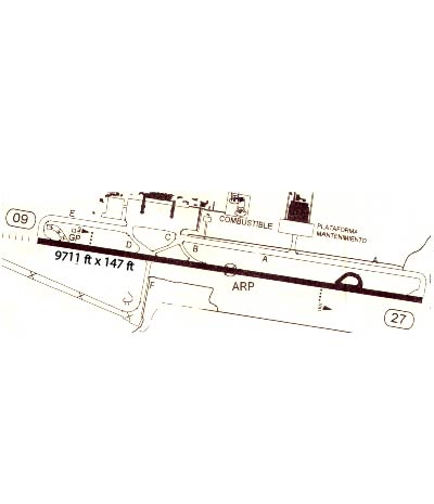
| RUNWAY INFORMATION: | Runway Ident: 27 /09
Runway Length: 9711
Runway Width: 144
Runway Surface: CONCRETE.
Runway PCN Rating: 059RBXU - Rigid, Subgrade-MEDIUM, Tire Pressure-MEDIUM LIMITED TO 217 PSI
Runway PCN Evaluation Method: By experience of aircraft using the pavement.
Runway Open: YES
| Runway 27 Information
Runway True Heading: 279°
Takeoff Distance Available: 9891
Landing Distance Available: 9711
Runway Latitude: N3232.3
Runway Longitude: W11657.3
Runway Elevation:
Runway Slope: N/A
Runway TDZE:
Runway Lighting: HIRL, ALSF-1, PAPI
| Runway 09 Information
Runway True Heading: 99°
Takeoff Distance Available: 9891
Landing Distance Available: 9711
Runway Latitude: N3232.6
Runway Longitude: W11659.1
Runway Elevation:
Runway Slope: N/A
Runway TDZE: 487
Runway Lighting: HIRL, SALS or SALSF, PAPI
|
|
|
| ILS INFORMATION | Rwy 09 ILS Information
DME
Glide Slope (3°)
Localizer (111.5)
|
|
COMMUNICATION INFORMATION
APPROACH CONTROL - TIJUANA APP
119.5 120.3
AUTOMATIC TERMINAL INFORMATION SERVICE - ATIS
127.9
CLEARANCE DELIVERY - TIJUANA CLNC DEL
122.35
MISCELLANEOUS - TIJUANA INFO
132.1
TOWER - TIJUANA TWR
118.1
|
AIRPORT NAVAIDS
TIJ - TIJUANA (VOR-DME) - ON FIELD
|