NOTICE: Information listed below may not be current.Airport Ident: MMPC
| Airport Name: INGENIERO JUAN GUILLERMO VILLASANA, Mexico
Location: Pachuca
Latitude: N2004.6 Longitude: W09847.0
Field Elevation: 7600' Variation: E6° as of 07/06
Time Zone: UTC-6(-5DT)
Daylight Savings: First Sunday in April to the last Saturday in October
Customs: N/A
|
|
| DISTANCE from: | KTEB to MMPC = 1774 nm
| KMIA to MMPC = 1077 nm
| KORD to MMPC = 1426 nm
| KDAL to MMPC = 774 nm
| KSEA to MMPC = 2002 nm
| KLAX to MMPC = 1335 nm
|
|
| AIRPORT TYPE: | | Active airports having permanent type surface runways with less than the minimum facilities. |
|
Rotating Beacon: NO
|
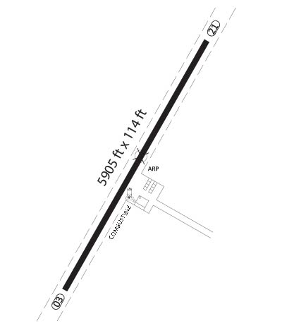
| RUNWAY INFORMATION: | Runway Ident: 21 /03
Runway Length: 6125
Runway Width: 85
Runway Surface: ASPHALT, ASPHALTIC CONCRETE, TAR MACADAM, OR BITUMEN BOUND MACADAM (INCLUDING ANY OF THESE SURFACE TYPES WITH CONCRETE ENDS).
Runway PCN Rating: -
Runway PCN Evaluation Method: N/A
Runway Open: YES
| Runway 21 Information
Runway True Heading: 214°
Takeoff Distance Available: 6825
Landing Distance Available: 6125
Runway Latitude: N2005.1
Runway Longitude: W09846.7
Runway Elevation:
Runway Slope: N/A
Runway TDZE:
Runway Lighting:
| Runway 03 Information
Runway True Heading: 34°
Runway Displaced Threshold: 68.5
Takeoff Distance Available: 6970
Landing Distance Available: 5440
Runway Latitude: N2004.2
Runway Longitude: W09847.3
Runway Elevation:
Runway Slope: N/A
Runway TDZE: N/A
Runway Lighting:
|
|
|
COMMUNICATION INFORMATION
AERODROME FLIGHT INFO SERVICE - AFIS
122.9
|
AIRPORT NAVAIDS
PCA - PACHUCA (VOR-DME) - Bearing: 234° Distance: 6.4 nm
|