
| ||||||||||||||||||||||||||||||||
| ||||||||||||||||||||||||||||||||
| ||||||||||||||||||||||||||||||||
 |  |
| ||||
NOTICE: Information listed below may not be current.
| ||||||||||
| ||||||||||
| ||||||||||
| Rotating Beacon: YES | ||||||||||
| ||||||||||
| ||||||||||
| COMMUNICATION INFORMATION ARRIVAL CONTROL - MEXICO ARR 129.6 AUTOMATIC TERMINAL INFORMATION SERVICE - ATIS 127.65 CLEARANCE DELIVERY - MEXICO CLNC DEL 122.1 DEPARTURE CONTROL - MEXICO DEP 120.5 GROUND CONTROL - GND 121.0 121.85 RADIO - MEXICO INFO 126.9 TOWER - MEXICO TWR 118.1 118.7 | ||||||||||
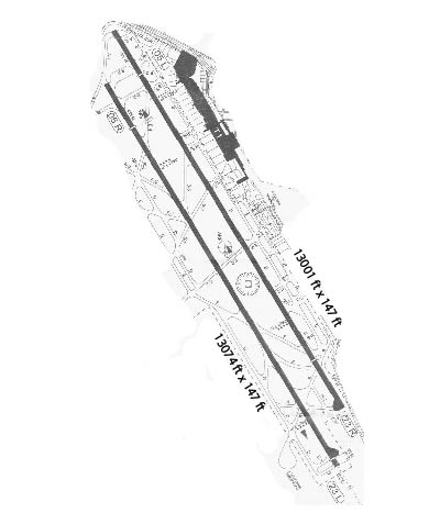
| INSTRUMENT APPROACHES VORDME 1 RW05L VORDME 1 RW05R VORDME 1 RW23L VORDME 1 RW23R ILS/DME 1 RW05R | ||||||||||
| APPROACH MINIMUMS VORDME 1 RW05L CIRCL Approach Minimums Category A: 7960' MSL and 1 MILE(s) Category B: 7960' MSL and 1 MILE(s) Category C: 7960' MSL and 1.75 MILE(s) Category D: 7960' MSL and 2 MILE(s) Category E: NA VORDME 1 RW05L S-05L Approach Minimums Category A: 7900' MSL and 1 MILE(s) Category B: 7900' MSL and 1 MILE(s) Category C: 7900' MSL and 1.5 MILE(s) Category D: 7900' MSL and 1.75 MILE(s) Category E: NA VORDME 1 RW05R CIRCL Approach Minimums Category A: 7960' MSL and 1 MILE(s) Category B: 7960' MSL and 1 MILE(s) Category C: 7960' MSL and 1.75 MILE(s) Category D: 7960' MSL and 2 MILE(s) Category E: NA VORDME 1 RW05R S-05R Approach Minimums Category A: 7900' MSL and 1 MILE(s) Category B: 7900' MSL and 1 MILE(s) Category C: 7900' MSL and 1.5 MILE(s) Category D: 7900' MSL and 1.75 MILE(s) Category E: NA VORDME 1 RW23L CIRCL Approach Minimums Category A: 7960' MSL and 1 MILE(s) Category B: 7960' MSL and 1 MILE(s) Category C: 7960' MSL and 1.75 MILE(s) Category D: 7960' MSL and 2 MILE(s) Category E: NA VORDME 1 RW23L S- 23 Approach Minimums Category A: 7900' MSL and 1 MILE(s) Category B: 7900' MSL and 1 MILE(s) Category C: 7900' MSL and 1.5 MILE(s) Category D: 7900' MSL and 1.75 MILE(s) Category E: NA VORDME 1 RW23R CIRCL Approach Minimums Category A: 7960' MSL and 1 MILE(s) Category B: 7960' MSL and 1 MILE(s) Category C: 7960' MSL and 1.75 MILE(s) Category D: 7960' MSL and 2 MILE(s) Category E: NA VORDME 1 RW23R S- 23 Approach Minimums Category A: 7900' MSL and 1 MILE(s) Category B: 7900' MSL and 1 MILE(s) Category C: 7900' MSL and 1.5 MILE(s) Category D: 7900' MSL and 1.75 MILE(s) Category E: NA ILS/DME 1 RW05R CIRCL Approach Minimums Category A: 7960' MSL and 1 MILE(s) Category B: 7960' MSL and 1 MILE(s) Category C: 7960' MSL and 1.75 MILE(s) Category D: 7960' MSL and 2 MILE(s) Category E: NA ILS/DME 1 RW05R S-ILS Approach Minimums Category A: 7600' MSL and 0.5 MILE(s) Category B: 7600' MSL and 0.5 MILE(s) Category C: 7600' MSL and 0.5 MILE(s) Category D: 7600' MSL and 0.5 MILE(s) Category E: NA ILS/DME 1 RW05R S-LOC Approach Minimums Category A: 7900' MSL and 0.75 MILE(s) Category B: 7900' MSL and 0.75 MILE(s) Category C: 7900' MSL and 1.25 MILE(s) Category D: 7900' MSL and 1.5 MILE(s) Category E: NA | ||||||||||
| APPROACH REMARKS ILS/DME 1 RW05R - S-ILS 05R* - *When SALS inop, increase CAT A-D vis to 3/4 mile. ILS/DME 1 RW05R - S-LOC 05R** - ** SEE MAIN REMARKS. | ||||||||||
| AIRPORT NAVAIDS MEX - MEXICO (VOR-DME) - ON FIELD MW - PLAZA (NDB) - Bearing: 60° Distance: 5.1 nm TPX - TEPEXPAN (NDB) - Bearing: 205° Distance: 12.2 nm | ||||||||||
| STANDARD INSTRUMENT DEPARTURE INFORMATION (SIDs) APAN3A APAN3A(RW05L/R) CUTLA1 CUTLA1(RW05L/R) POTS1B POTSI1B(RW23L/R) RIOJ2B RIOJA2B(RW23L/R) TOLU1A TOULCA 1A (RW05L/R) TOLU1B TOLUCA 1B (RW23L/R) TOLU1C TOLUCA 1C (RW23L/R) TULA3B TULAS 3B (RW23L/R) VISS1 VISOS1(RW05L/R) | ||||||||||
| TERMINAL AREA REMARKS APAN3A APAN3A(RW05L/R) ALL DEPARTURES: Max take-off speed is 200 KIAS until VASOS. In case of failure of MEX VOR/DME and other navaids involved in each procedure expect RADAR Vectors . These departures can be changed in accordance with ATC instructions by meanso f RADAR Vectors and/or speed changes. DEPARTURE ROUTE DESCRIPTION: TAKE-OFF RWY 05L/R: Climb via MEX R-052, thence... APAN3A: to VASOS, then turn right climbing to intercept APN R-248 and proceed to APN/DME. Maintain 15,000 until APN VOR/DME 13 DME, then proceed via assigned r oute or according to ATC instructions. CUTLA1 CUTLA1(RW05L/R) ALL DEPARTURES: Max take-off speed is 200 KIAS until VASOS. In case of failure of MEX VOR/DME and other navaids involved in each procedure expect RADAR Vectors . These departures can be changed in accordance with ATC instructions by meanso f RADAR Vectors and/or speed changes. DEPARTURE ROUTE DESCRIPTION: TAKE-OFF RWY 05L/R: To VASOS, then turn right climb ing to intercept OTU VOR/DME R-197 and proceed to OTU 21 DME, then turn left cli mbing to intercept CUA VOR/DME R-351 and proceed to CUA VOR/DME. Maintain 15,00 0 until crossing MEX VOR/DME 15 DME or until 27 DME from CUA VOR/JDME and procee d via assigned route or according to ATC instructions. POTS1B POTSI1B(RW23L/R) DEPARTURE ROUTE DESCRIPTION: ALL DEPARTURES: Maximum take-off is 180 KIAS until MEX 4 DME. In case of failure of MEX VOR/DME and other navaids involved in proc edure expect RADAR Vectors. These departures can be changed in accordance with A TC instructions by means of RADAR Vectors and/or speed changes. POTSI ONE BRAVO: Climb via MEX R-232 to MEX 4 DME, turn right climbing to intercept and proceed via SMO VOR/DME R-160 to SMO VOR/DME, cross SMO VOR at or above 11,200. Proceed via SMO R-345 to POTSI, maintain 15,000 until SMO 24 DME or crossing SLM VOR/DM E R-305, and continue via assigned route or according to ATC instructions. RIOJ2B RIOJA2B(RW23L/R) DEPARTURE ROUTE DESCRIPTION: ALL DEPARTURES: Maximum take-off is 180 KIAS until MEX 4 DME. In case of failure of MEX VOR/DME and other navaids involved in proce dure expect RADAR Vectors. These departures can be changed in accordance with AT C instructions by means of RADAR Vectors and/or speed changes. RIOJA TWO BRAVO: Climb via MEX VOR/DME R-232 to MEX 4 DME, turn right climbing to intercept and proceed via SMO VOR/DME R-160 to SMO VOR/DME, cross SMO VOR at or above 11,200, proceed via SMO R-330 to RIOJA, maintain 15,000 until SMO 24 DME or crossing SL M VOR/DME R-301, and continue via assigned route or according to ATC instruction s. TOLU1A TOULCA 1A (RW05L/R) ALL DEPARTURES: Max take-off speed is 200 KIAS until VASOS. In case of failure of MEX VOR/DME and other navaids involved in each procedure expect RADAR Vectors . These departures can be changed in accordance with ATC instructions by meanso f RADAR Vectors and/or speed changes. DEPARTURE ROUTE DESCRIPTION: TAKE-OFF RWY 05L/R: To VASOS, then turn right climb ing to intercept OTU VOR/DME R-197 and proceed to OTU 21 DME, then turn right cl imbing to intercept TLC VOR/DME R-085 and proceed to TLC VOR/DME. Maintain 15, 000 until crossing TLC 15 DME and proceed via assigned route or according to ATC instructions. TOLU1B TOLUCA 1B (RW23L/R) DEPARTURE ROUTE DESCRIPTION: ALL DEPARTURES: Maximum take-off is 180 KIAS until MEX 4 DME. In case of failure of MEX VOR/DME and other navaids involved in proce dure expect RADAR Vectors. These departures can be changed in accordance with AT C instructions by means of RADAR Vectors and/or speed changes.TOLUCA ONE BRAVO: Climb via MEX VOR/DME R-232 to MEX 4 DME, turn right climbing to intercept and proceed via SMO R-160 to SMO VOR/DME, cross SMO VOR at or above 11,200, then tur n left to intercept TLC VOR/DME R-040, then proceed to TLC VOR/DME, maintain 15, 000 until TLC 9 DME and continue via assigned route or according to ATC instruct ions. TOLU1C TOLUCA 1C (RW23L/R) DEPARTURE ROUTE DESCRIPTION: ALL DEPARTURES: Maximum take-off is 180 KIAS until MEX 4 DME. In case of failure of MEX VOR/DME and other navaids involved in proce dure expect RADAR Vectors. These departures can be changed in accordance with AT C instructions by means of RADAR Vectors and/or speed changes. TOLUCA ONE CHARLI E: Climb via MEX VOR/DME R-232 to MEX 11 DME, turn right to intercept TLC R-085 proceed to TLC VOR/DME, maintain 15,000 until TLC 15 DME and continue via assig ned route or according to ATC instructions. TULA3B TULAS 3B (RW23L/R) DEPARTURE ROUTE DESCRIPTION: ALL DEPARTURES: Maximum take-off is 180 KIAS until MEX 4 DME. In case of failure of MEX VOR/DME and other navaids involved in proc edure expect RADAR Vectors. These departures can be changed in accordance with A TC instructions by means of RADAR Vectors and/or speed changes. TULAS THREE BRAV O: Climb via MEX VOR/DME R-232 to MEX 4 DME, turn right climbing to intercept a nd proceed via SMO VOR/DMER-160 to SMO VOR/DME, cross SMO VOR/DME at or above 11 ,200, proceed via SMO R-360 to TULAS, maintain 15,000 until SMO 24 DME or crossi ng SLM VOR/DME R-322, and continue via assigned route or according to ATC instru ctions. VISS1 VISOS1(RW05L/R) ALL DEPARTURES: Maximum take-off speed is 200 KIAS until VASOS. In case of fail ure of MEX VOR/DME and other navaids involved in each procedure expect RADAR Vec tors. These departures can be changed in accordance with ATC instructions by me ans of RADAR Vectors and/or speed changes. DEPARTURE ROUTE DESCRIPTION: TAKE-OFF RWY 05L/R: To VASOS, continue outbound via MEX VOR/DME R-052 climbing to maintain 15,000 until crossing 31 DME from MEX VO R/DME, then continue climb toward VISOS, then turn left to intercept APN VOR/DME R-003 to TAM VOR/DME, then via assigned route or according to ATC instructions. VORDME 1 RW05L Max airspeed 160 KIAS from IAF At SLM VOR/DME and MEX VOR/DME: Max holding 310 KIAS. Min holding alt 11,000. MISSED APPROACH: Climb outbound on the R-052 until 6 DME fix from MEX VOR/DME, t hen left turn climb to intercept SLM VOR/DME R-157 climbing to 11,000 and await ATC instructions. VORDME 1 RW05R Max airspeed 160 KIAS from IAF At SLM VOR/DME and MEX VOR/DME: Max holding 310 KIAS. Min holding alt 11,000. MISSED APPROACH: Climb outbound on the R-052 until 6 DME fix from MEX VOR/DME, t hen left turn climb to intercept SLM VOR/DME R-157 climbing to 11,000 and await ATC instructions. VORDME 1 RW23L DME REQUIRED. Max holding 310 KIAS. Min holding alt 11,000. MISSED APPROACH: Climb direct to MW LOM. Turn left and continue climbing inboun d on MEX VOR/DME R-200 MEX VOR/DME to the minimum holding altitude. VORDME 1 RW23R DME REQUIRED. Max holding 310 KIAS. Min holding alt 11,000. MISSED APPROACH: Climb direct to MW LOM. Turn left and continue climbing inboun d on MEX VOR/DME R-200 MEX VOR/DME to the minimum holding altitude. ILS/DME 1 RW05R DME REQUIRED FOR LOCALIZER. Max airspeed 160 KIAS from IAF ** When SALS inop, increase CAT A-B vis to 1 mile, CAT C to 1 1/2 mile, CAT D to 1 3/4 mile. At SLM VOR/DME: Max holding 310 KIAS. Min holding alt 11,000. At MEX VOR/DME: Max holding 310 KIAS. Min holding alt 11,000. Glide Slope Angle 3.00 Deg/TCH 52 . MISSED APPROACH: Climb outbound on the R-052 until 6 DME fix from MEX VOR/DME, t hen left turn climb to intercept SLM VOR/DME R-157 climbing to 11,000 and await ATC instructions. | ||||||||||
| CLIMB/DECENT RATE INFORMATION RWY 05L (APAN3A APAN3A(RW05L/R)) REQUIRES A CLIMB RATE (AT 60 KNOTS) OF 320'/min TO 14000' RWY 05R (APAN3A APAN3A(RW05L/R)) REQUIRES A CLIMB RATE (AT 60 KNOTS) OF 320'/min TO 14000' RWY 05L (CUTLA1 CUTLA1(RW05L/R)) REQUIRES A CLIMB RATE (AT 60 KNOTS) OF 290'/min TO 15000' RWY 05R (CUTLA1 CUTLA1(RW05L/R)) REQUIRES A CLIMB RATE (AT 60 KNOTS) OF 290'/min TO 15000' RWY 23L (POTS1B POTSI1B(RW23L/R)) REQUIRES A CLIMB RATE (AT 60 KNOTS) OF 320'/min TO 15000' RWY 23R (POTS1B POTSI1B(RW23L/R)) REQUIRES A CLIMB RATE (AT 60 KNOTS) OF 320'/min TO 15000' RWY 23L (RIOJ2B RIOJA2B(RW23L/R)) REQUIRES A CLIMB RATE (AT 60 KNOTS) OF 320'/min TO 15000' RWY 23R (RIOJ2B RIOJA2B(RW23L/R)) REQUIRES A CLIMB RATE (AT 60 KNOTS) OF 320'/min TO 15000' RWY 05L (TOLU1A TOULCA 1A (RW05L/R)) REQUIRES A CLIMB RATE (AT 60 KNOTS) OF 290'/min TO 15000' RWY 05R (TOLU1A TOULCA 1A (RW05L/R)) REQUIRES A CLIMB RATE (AT 60 KNOTS) OF 290'/min TO 15000' RWY 23L (TOLU1B TOLUCA 1B (RW23L/R)) REQUIRES A CLIMB RATE (AT 60 KNOTS) OF 370'/min TO 15000' RWY 23R (TOLU1B TOLUCA 1B (RW23L/R)) REQUIRES A CLIMB RATE (AT 60 KNOTS) OF 370'/min TO 15000' RWY 23L (TOLU1C TOLUCA 1C (RW23L/R)) REQUIRES A CLIMB RATE (AT 60 KNOTS) OF 320'/min TO 15000' RWY 23R (TOLU1C TOLUCA 1C (RW23L/R)) REQUIRES A CLIMB RATE (AT 60 KNOTS) OF 320'/min TO 15000' RWY 23L (TULA3B TULAS 3B (RW23L/R)) REQUIRES A CLIMB RATE (AT 60 KNOTS) OF 320'/min TO 15000' RWY 23R (TULA3B TULAS 3B (RW23L/R)) REQUIRES A CLIMB RATE (AT 60 KNOTS) OF 320'/min TO 15000' RWY 05L (VISS1 VISOS1(RW05L/R)) REQUIRES A CLIMB RATE (AT 60 KNOTS) OF 240'/min TO 14000' RWY 05R (VISS1 VISOS1(RW05L/R)) REQUIRES A CLIMB RATE (AT 60 KNOTS) OF 240'/min TO 14000' | ||||||||||
| AIRPORT REMARKS IFR TAKE-OFF MINIMUMS AND DEPARTURE PROCEDURES Diverse departures not authorized. | ||||||||||