NOTICE: Information listed below may not be current.Airport Ident: MMMM
| Airport Name: GENERAL FRANCISCO J MUJICA INTL, Mexico
Location: Morelia
Latitude: N1951.0 Longitude: W10101.5
Field Elevation: 6033' Variation: E7° as of 01/06
Time Zone: UTC-6(-5DT)
Daylight Savings: First Sunday in April to the last Saturday in October
Customs: Airport Of Entry
|
|
| DISTANCE from: | KTEB to MMMM = 1866 nm
| KMIA to MMMM = 1199 nm
| KORD to MMMM = 1485 nm
| KDAL to MMMM = 811 nm
| KSEA to MMMM = 1954 nm
| KLAX to MMMM = 1254 nm
|
|
| AIRPORT TYPE: | | Active civil airports controlled and operated by civil authorities primarily for use by civil aircraft, although military may have landing privileges and/or contract rights. Minimum facilities are available which include: control tower (or some similar control system, such as a Flight Service Station which issues clearances and advisories when there is no tower or the tower is not in operation), lighting (may be flare pots, etc.), petrol, oils and lubricants (POL), and facilities for organizational maintenance or better. |
|
Rotating Beacon: NO
|
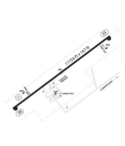
| RUNWAY INFORMATION: | Runway Ident: 23 /05
Runway Length: 11155
Runway Width: 148
Runway Surface: ASPHALT, ASPHALTIC CONCRETE, TAR MACADAM, OR BITUMEN BOUND MACADAM (INCLUDING ANY OF THESE SURFACE TYPES WITH CONCRETE ENDS).
Runway PCN Rating: -
Runway PCN Evaluation Method: N/A
Runway Open: YES
| Runway 23 Information
Runway True Heading: 235°
Takeoff Distance Available: 11345
Landing Distance Available: 11155
Runway Latitude: N1951.5
Runway Longitude: W10100.7
Runway Elevation:
Runway Slope: N/A
Runway TDZE:
Runway Lighting: HIRL, SALS or SALSF, PAPI
| Runway 05 Information
Runway True Heading: 55°
Takeoff Distance Available: 11345
Landing Distance Available: 11155
Runway Latitude: N1950.5
Runway Longitude: W10102.3
Runway Elevation:
Runway Slope: N/A
Runway TDZE: N/A
Runway Lighting: HIRL, PAPI
|
|
|
COMMUNICATION INFORMATION
APPROACH CONTROL - MORELIA APP/TWR
118.5
|
AIRPORT NAVAIDS
MLM - MORELIA (VOR-DME) - ON FIELD
|