NOTICE: Information listed below may not be current.Airport Ident: MMML
| Airport Name: GENERAL RODOLFO SANCHEZ TABOADA INTL, Mexico
Location: Mexicali
Latitude: N3237.8 Longitude: W11514.5
Field Elevation: 74' Variation: E12° as of 01/06
Time Zone: UTC-8(-7DT)
Daylight Savings: N/A
Customs: Airport Of Entry
|
|
| DISTANCE from: | KTEB to MMML = 2021 nm
| KMIA to MMML = 1866 nm
| KORD to MMML = 1412 nm
| KDAL to MMML = 927 nm
| KSEA to MMML = 946 nm
| KLAX to MMML = 178 nm
|
|
| AIRPORT TYPE: | | Active civil airports controlled and operated by civil authorities primarily for use by civil aircraft, although military may have landing privileges and/or contract rights. Minimum facilities are available which include: control tower (or some similar control system, such as a Flight Service Station which issues clearances and advisories when there is no tower or the tower is not in operation), lighting (may be flare pots, etc.), petrol, oils and lubricants (POL), and facilities for organizational maintenance or better. |
|
Rotating Beacon: YES
|
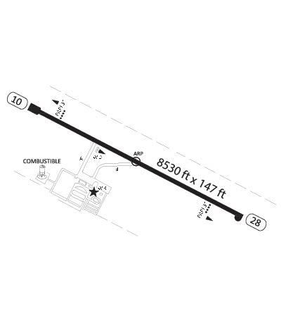
| RUNWAY INFORMATION: | Runway Ident: 28 /10
Runway Length: 8530
Runway Width: 148
Runway Surface: CONCRETE.
Runway PCN Rating: 048RBXT - Rigid, Subgrade-MEDIUM, Tire Pressure-MEDIUM LIMITED TO 217 PSI
Runway PCN Evaluation Method: Technical Evaluation.
Runway Open: YES
| Runway 28 Information
Runway True Heading: 298°
Takeoff Distance Available: 8730
Landing Distance Available: 8530
Runway Latitude: N3237.5
Runway Longitude: W11513.8
Runway Elevation:
Runway Slope: N/A
Runway TDZE:
Runway Lighting: HIRL, PAPI
| Runway 10 Information
Runway True Heading: 118°
Takeoff Distance Available: 8730
Landing Distance Available: 8530
Runway Latitude: N3238.2
Runway Longitude: W11515.2
Runway Elevation:
Runway Slope: N/A
Runway TDZE: N/A
Runway Lighting: HIRL, PAPI
|
|
|
COMMUNICATION INFORMATION
AERODROME FLIGHT INFO SERVICE - MEXICALI INFO
123.9
APPROACH CONTROL - MEXICALI APP/TWR
118.2
AUTOMATIC TERMINAL INFORMATION SERVICE - ATIS
127.6
|
AIRPORT NAVAIDS
MXL - MEXICALI (VOR-DME) - ON FIELD
|