Current Weather/Notams (Metars, TAFs, Notams, NWS Forecast, PIREPS, and nearby weather)
Customs Information Send updates to Support@FltPlan.com
Customs Not Available
Database effective 05/16/2024
Airport Diagram might not be current. Facility Name: ZANESVILLE MUNI City Name: ZANESVILLE County: MUSKINGUM State abbrev: OH State Name: OHIO Ownership: PUBLICLY OWNED Use: OPEN TO THE PUBLIC Owner's Name: CITY OF ZANESVILLE Address: 401 MARKET ST ZANESVILLE, OH 43701-3520 Owner's Phone: 740-455-0663 Manager's Name: JIM WITTE; JIM.WITTE@COZ.ORG. Address: 850 AIRPORT RD ZANESVILLE, OH 43701-0969 Phone: 740-452-3625 FAA Region: GREAT LAKES FAA Field Office: DET
Runway Identifications Help
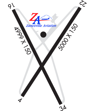
Runway Identification: 04/22 Length: 4999 ftWidth: 150 ftSurface: ASPHALT-GOOD CONDITIONEdge lights: High Intensity Treatment: NONE Runway: 04 Runway: 22 Mag heading: 40° Mag heading: 220° Rwy Slope: -.53% Down Rwy Slope: .53% Up Approach: Approach: ILS/DME Pattern: Left Traffic Pattern: Left Traffic Markings: NONPRECISION INSTRUMENT Markings: PRECISION INSTRUMENT Marking Condition: POOR; FADED. Marking Condition: POOR; FADED. Arresting Dev: Arresting Dev: Lat & Long: N3956.3 W08153.8 Lat. & Long.: N3957.0 W08153.2 Elev: 896.1 ft. MSL Elev: 869.4 ft. MSL TCH: 35 ft. AGL TCH: 47 ft. AGL Visual Glide Path: 3.00 degrees Visual Glide Path: 3.00 degrees Displaced Threshold: No Displaced Threshold: No Touchdown Zone: YES Touchdown Zone: YES Touchdown Elev.: 899.8 feet Touchdown Elev.: 891.7 feet Visual Glide Slope: 4-Light PAPI on RIGHT side of Runway; PAPI UNUSBL BYD 4 DEGS RIGHT OF CNTRLN. Visual Glide Slope: 4-Light PAPI on LEFT side of Runway RVR Equipment: RVR Equipment: RVV Equipment: NO RVV Equipment: NO Approach Lights: Approach Lights: REIL: YES REIL: YES Centerline Lights: NO Centerline Lights: NO Touchdown lights: NO Touchdown lights: NO Runway Category: Runway with a Non-precision Approach having visibility minimums greater than 3/4 mile Runway Category: Precision Instrument Runway Declared Distances: Declared Distances: Comments: +5 FT BRUSH, 0-95 FT DIST, 180-245 FT R. Comments:
Runway Identification: 16/34 Length: 4998 ftWidth: 75 ftSurface: ASPHALT-GOOD CONDITIONEdge lights: Medium Intensity Treatment: AGGREGATE FRICTION SEAL COAT Runway: 16 Runway: 34 Mag heading: 158° Mag heading: 338° Rwy Slope: .57% Up Rwy Slope: -.57% Down Approach: Approach: Pattern: Left Traffic Pattern: Left Traffic Markings: NONPRECISION INSTRUMENT Markings: NONPRECISION INSTRUMENT Marking Condition: GOOD Marking Condition: GOOD Arresting Dev: Arresting Dev: Lat & Long: N3957.0 W08153.8 Lat. & Long.: N3956.3 W08153.4 Elev: 866.7 ft. MSL Elev: 895.4 ft. MSL TCH: TCH: Visual Glide Path: Visual Glide Path: Displaced Threshold: 200 feet Displaced Threshold: 200 feet Touchdown Zone: YES Touchdown Zone: YES Touchdown Elev.: 895.3 feet Touchdown Elev.: 897.4 feet Visual Glide Slope: Visual Glide Slope: 4-Light PAPI on LEFT side of Runway RVR Equipment: RVR Equipment: RVV Equipment: NO RVV Equipment: NO Approach Lights: Approach Lights: REIL: YES REIL: YES Centerline Lights: NO Centerline Lights: NO Touchdown lights: NO Touchdown lights: NO Runway Category: Runway with a Visual Approach Runway Category: Runway with a Visual Approach Declared Distances: TORA:4998' TODA:4998' ASDA:4798' LDA:4598' Declared Distances: TORA:4998' TODA:4998' ASDA:4798' LDA:4598' Obstructions: TREES Obstructions: TREES Marked: NOT Marked/Lighted Marked: NOT Marked/Lighted Clearance slope: 18:1; OBST CLNC SLP 32:1 TO DTHR. Clearance slope: 6:1; OBST CLNC SLP 30:1 TO DTHR. Obstruction height: 35 feet AGL Obstruction height: 15 feet AGL Dist. from runway: 850 feet Dist. from runway: 290 feet Centerline offset: 75 left of centerline Centerline offset: 100 feet left of centerline Comments: +2-5 FT BRUSH, 125 FT DIST, 130 FT L/R. Comments: