Current Weather/Notams (Metars, TAFs, Notams, NWS Forecast, PIREPS, and nearby weather)
Customs Information Send updates to Support@FltPlan.com
Customs Not Available
Database effective 05/16/2024
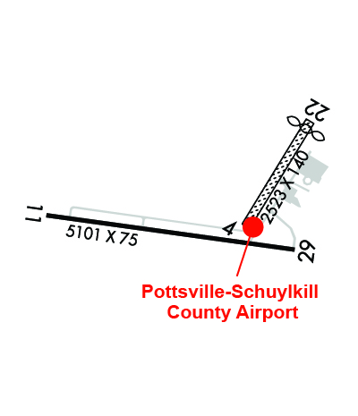
Airport Diagram might not be current. Facility Name: SCHUYLKILL COUNTY/JOE ZERBEY City Name: POTTSVILLE County: SCHUYLKILL State abbrev: PA State Name: PENNSYLVANIA Ownership: PUBLICLY OWNED Use: OPEN TO THE PUBLIC Owner's Name: SCHUYLKILL COUNTY A/P AUTH Address: 240 AIRPORT ROAD POTTSVILLE, PA 17901 Owner's Phone: 570-544-6002 Manager's Name: BILL WILLARD Address: 240 AIRPORT ROAD POTTSVILLE, PA 17901 Phone: (570) 617-6002 FAA Region: EASTERN FAA Field Office: HAR
Runway Identifications Help
Runway Identification: 04/22 Length: 2523 ftWidth: 140 ftSurface: GRASS-GOOD CONDITIONEdge lights: Treatment: NONE Runway: 04 Runway: 22 Mag heading: 43° Mag heading: 223° Rwy Slope: .41% Up Rwy Slope: -.41% Down Approach: Approach: Pattern: Left Traffic Pattern: Left Traffic Markings: NONE Markings: NONE Marking Condition: POOR; RY 04/22 EDGE & DSPLCD THLD MKD WITH ORANGE CONES. Marking Condition: POOR Arresting Dev: Arresting Dev: Lat & Long: N4042.4 W07622.2 Lat. & Long.: N4042.7 W07622.0 Elev: 1708.1 ft. MSL Elev: 1718.4 ft. MSL TCH: TCH: Visual Glide Path: Visual Glide Path: Displaced Threshold: No Displaced Threshold: 200 feet Touchdown Zone: YES Touchdown Zone: YES Touchdown Elev.: 1718.4 feet Touchdown Elev.: 1715.8 feet Visual Glide Slope: Visual Glide Slope: RVR Equipment: RVR Equipment: RVV Equipment: NO RVV Equipment: NO Approach Lights: Approach Lights: REIL: NO REIL: NO Centerline Lights: NO Centerline Lights: NO Touchdown lights: NO Touchdown lights: NO Runway Category: Runway with a Visual Approach Runway Category: Runway with a Visual Approach Declared Distances: Declared Distances: Obstructions: Obstructions: TREES Marked: Marked: NOT Marked/Lighted Clearance slope: 20:1 Clearance slope: 12:1; APCH RATIO 19:1 TO DTHR. Obstruction height: Obstruction height: 27 feet AGL Dist. from runway: Dist. from runway: 320 feet Centerline offset: Centerline offset: 110 feet right of centerline Comments: Comments:
Runway Identification: 11/29 Length: 5101 ftWidth: 75 ftSurface: ASPHALT-GOOD CONDITIONEdge lights: Medium Intensity Treatment: NONE Runway: 11 Runway: 29 Mag heading: 110° Mag heading: 290° Rwy Slope: -.45% Down Rwy Slope: .45% Up Approach: Approach: Pattern: Left Traffic Pattern: Left Traffic Markings: NONPRECISION INSTRUMENT Markings: NONPRECISION INSTRUMENT Marking Condition: GOOD Marking Condition: GOOD Arresting Dev: Arresting Dev: Lat & Long: N4042.4 W07623.1 Lat. & Long.: N4042.3 W07622.0 Elev: 1729.7 ft. MSL Elev: 1706.5 ft. MSL TCH: 40 ft. AGL TCH: 45 ft. AGL Visual Glide Path: 3.00 degrees Visual Glide Path: 3.00 degrees Displaced Threshold: No Displaced Threshold: No Touchdown Zone: YES Touchdown Zone: YES Touchdown Elev.: 1729.8 feet Touchdown Elev.: 1723.8 feet Visual Glide Slope: 2-Light PAPI on LEFT side of Runway Visual Glide Slope: 2-Light PAPI on LEFT side of Runway RVR Equipment: RVR Equipment: RVV Equipment: NO RVV Equipment: NO Approach Lights: Approach Lights: REIL: YES REIL: YES Centerline Lights: NO Centerline Lights: NO Touchdown lights: NO Touchdown lights: NO Runway Category: D Runway Category: D Declared Distances: Declared Distances: Obstructions: TREES Obstructions: TREES Marked: NOT Marked/Lighted Marked: NOT Marked/Lighted Clearance slope: 9:1 Clearance slope: 3:1 Obstruction height: 31 feet AGL Obstruction height: 21 feet AGL Dist. from runway: 482 feet Dist. from runway: 265 feet Centerline offset: 535 right of centerline Centerline offset: 393 feet right of centerline Comments: Comments: