Current Weather/Notams (Metars, TAFs, Notams, NWS Forecast, PIREPS, and nearby weather)
Customs Information Send updates to Support@FltPlan.com
Customs Not Available
Database effective 05/16/2024
Airport Diagram might not be current.
|
| Facility Name: | CHAN GURNEY MUNI |
| City Name: | YANKTON |
| County: | YANKTON |
| State abbrev: | SD |
| State Name: | SOUTH DAKOTA |
| | |
| Ownership: | PUBLICLY OWNED |
| Use: | OPEN TO THE PUBLIC |
| Owner's Name: | CITY OF YANKTON |
| Address: | PO BOX 176 |
| | YANKTON, SD 57078 |
| Owner's Phone: | 605-668-5288 |
| | |
| Manager's Name: | MIKE ROINSTAD |
| Address: | 700 EAST 31ST STREET |
| | YANKTON, SD 57078 |
| Phone: | 605-661-9223 |
| | |
| FAA Region: | GREAT LAKES |
| FAA Field Office: | DMA |
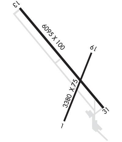
Runway Identifications
Runway Identification: 02/20Length: 3380 ft
Width: 60 ft
Surface: ASPHALT
Edge lights: Medium IntensityTreatment: NONE
| | Runway: 02 | | Runway: 20 |
| Mag heading: | 18° | Mag heading: | 198° |
| Rwy Slope: | .24% Up | Rwy Slope: | -.24% Down |
| Approach: | | Approach: | |
| Pattern: | Left Traffic | Pattern: | Left Traffic |
| Markings: | NONPRECISION INSTRUMENT | Markings: | NONPRECISION INSTRUMENT |
| Marking Condition: | GOOD | Marking Condition: | GOOD |
| Arresting Dev: | | Arresting Dev: | |
| Lat & Long: | N4254.6 W09723.2 | Lat. & Long.: | N4255.1 W09722.9 |
| Elev: | 1273.6 ft. MSL | Elev: | 1281.7 ft. MSL |
| TCH: | 25 ft. AGL | TCH: | 25 ft. AGL |
| Visual Glide Path: | 3.00 degrees | Visual Glide Path: | 3.00 degrees |
| Displaced Threshold: | No | Displaced Threshold: | No |
| Touchdown Zone: | YES | Touchdown Zone: | YES |
| Touchdown Elev.: | 1279.8 feet | Touchdown Elev.: | 1281.7 feet |
| Visual Glide Slope: | 2-Light PAPI on LEFT side of Runway | Visual Glide Slope: | 2-Light PAPI on LEFT side of Runway |
| RVR Equipment: | | RVR Equipment: | |
| RVV Equipment: | NO | RVV Equipment: | NO |
| Approach Lights: | | Approach Lights: | |
| REIL: | NO | REIL: | NO |
| Centerline Lights: | NO | Centerline Lights: | NO |
| Touchdown lights: | NO | Touchdown lights: | NO |
| Runway Category: | Runway with a Visual Approach | Runway Category: | Runway with a Visual Approach |
| Declared Distances: | | Declared Distances: | |
| Obstructions: | PLINE | Obstructions: | FENCE |
| Marked: | MARKED | Marked: | NOT Marked/Lighted |
| Clearance slope: | 26:1 | Clearance slope: | 30:1 |
| Obstruction height: | 7 feet AGL | Obstruction height: | 6 feet AGL |
| Dist. from runway: | 385 feet | Dist. from runway: | 382 feet |
| Centerline offset: | 94 right of centerline | Centerline offset: | 11 feet right of centerline |
| Comments: | | Comments: | |
Runway Identification: 13/31Length: 6094 ft
Width: 100 ft
Surface: CONCRETE
Edge lights: High IntensityTreatment: NONE
| | Runway: 13 | | Runway: 31 |
| Mag heading: | 137° | Mag heading: | 317° |
| Rwy Slope: | -.58% Down | Rwy Slope: | .58% Up |
| Approach: | | Approach: | ILS |
| Pattern: | Left Traffic | Pattern: | Left Traffic |
| Markings: | PRECISION INSTRUMENT | Markings: | PRECISION INSTRUMENT |
| Marking Condition: | GOOD | Marking Condition: | GOOD |
| Arresting Dev: | | Arresting Dev: | |
| Lat & Long: | N4255.5 W09723.7 | Lat. & Long.: | N4254.7 W09722.8 |
| Elev: | 1305.9 ft. MSL | Elev: | 1270.6 ft. MSL |
| TCH: | 41 ft. AGL | TCH: | 48 ft. AGL |
| Visual Glide Path: | 3.00 degrees | Visual Glide Path: | 3.00 degrees |
| Displaced Threshold: | No | Displaced Threshold: | No |
| Touchdown Zone: | YES | Touchdown Zone: | YES |
| Touchdown Elev.: | 1305.9 feet | Touchdown Elev.: | 1284.7 feet |
| Visual Glide Slope: | 4-BOX VASI ON LEFT SIDE OF RUNWAY | Visual Glide Slope: | 4-BOX VASI ON LEFT SIDE OF RUNWAY |
| RVR Equipment: | | RVR Equipment: | |
| RVV Equipment: | NO | RVV Equipment: | NO |
| Approach Lights: | | Approach Lights: | MALSR - 1,400 foot medium intensity approach lighting system with runway alignment indicator lights |
| REIL: | YES | REIL: | NO |
| Centerline Lights: | NO | Centerline Lights: | NO |
| Touchdown lights: | NO | Touchdown lights: | NO |
| Runway Category: | D | Runway Category: | Precision Instrument Runway |
| Declared Distances: | | Declared Distances: | |

