Current Weather/Notams (Metars, TAFs, Notams, NWS Forecast, PIREPS, and nearby weather)
Customs Information Send updates to Support@FltPlan.com
Customs Not Available
Database effective 04/18/2024
Airport Diagram might not be current.
|
| Facility Name: | CRANDON/STEVE CONWAY MUNI |
| City Name: | CRANDON |
| County: | FOREST |
| State abbrev: | WI |
| State Name: | WISCONSIN |
| | |
| Ownership: | PUBLICLY OWNED |
| Use: | OPEN TO THE PUBLIC |
| Owner's Name: | CITY OF CRANDON |
| Address: | 601 W. WASHINGTON ST, PO BOX 335 |
| | CRANDON, WI 54520 |
| Owner's Phone: | 715-478-2400 |
| | |
| Manager's Name: | NORMAN KNOLL |
| Address: | 8765 MARY ST |
| | ARGONNE, WI 54511 |
| Phone: | 715-649-3225; ADDL PHONE 715-493-7556. |
| | |
| FAA Region: | GREAT LAKES |
| FAA Field Office: | CHI |
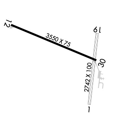
Runway Identifications
Runway Identification: 01/19Length: 2742 ft
Width: 100 ft
Surface: GRASS-GOOD CONDITION
Edge lights: Treatment: NONE
| | Runway: 01 | | Runway: 19 |
| Mag heading: | N/A | Mag heading: | N/A |
| Rwy Slope: | .45% Up | Rwy Slope: | -.45% Down |
| Approach: | | Approach: | |
| Pattern: | Left Traffic | Pattern: | Left Traffic |
| Markings: | | Markings: | |
| Marking Condition: | MKD WITH YELLOW CONES. | Marking Condition: | MKD WITH YELLOW CONES. |
| Arresting Dev: | | Arresting Dev: | |
| Lat & Long: | N4531.0 W08855.5 | Lat. & Long.: | N4531.5 W08855.5 |
| Elev: | 1614.5 ft. MSL | Elev: | 1626.8 ft. MSL |
| TCH: | | TCH: | |
| Visual Glide Path: | | Visual Glide Path: | |
| Displaced Threshold: | No | Displaced Threshold: | No |
| Touchdown Zone: | YES | Touchdown Zone: | YES |
| Touchdown Elev.: | 1626.8 feet | Touchdown Elev.: | 1626.8 feet |
| Visual Glide Slope: | | Visual Glide Slope: | |
| RVR Equipment: | | RVR Equipment: | |
| RVV Equipment: | NO | RVV Equipment: | NO |
| Approach Lights: | | Approach Lights: | |
| REIL: | NO | REIL: | NO |
| Centerline Lights: | NO | Centerline Lights: | NO |
| Touchdown lights: | NO | Touchdown lights: | NO |
| Runway Category: | Runway with a Visual Approach | Runway Category: | Runway with a Visual Approach |
| Declared Distances: | | Declared Distances: | |
Runway Identification: 12/30Length: 3550 ft
Width: 75 ft
Surface: ASPHALT-FAIR CONDITION
Edge lights: Medium IntensityTreatment: NONE
| | Runway: 12 | | Runway: 30 |
| Mag heading: | N/A | Mag heading: | N/A |
| Rwy Slope: | -.63% Down | Rwy Slope: | .63% Up |
| Approach: | | Approach: | |
| Pattern: | Left Traffic | Pattern: | Left Traffic |
| Markings: | NONPRECISION INSTRUMENT | Markings: | NONPRECISION INSTRUMENT |
| Marking Condition: | POOR; MARKINGS FADED. | Marking Condition: | POOR; MARKINGS FADED. |
| Arresting Dev: | | Arresting Dev: | |
| Lat & Long: | N4531.5 W08856.2 | Lat. & Long.: | N4531.3 W08855.5 |
| Elev: | 1649.8 ft. MSL | Elev: | 1627.5 ft. MSL |
| TCH: | | TCH: | |
| Visual Glide Path: | | Visual Glide Path: | |
| Displaced Threshold: | No | Displaced Threshold: | No |
| Touchdown Zone: | YES | Touchdown Zone: | YES |
| Touchdown Elev.: | 1650.0 feet | Touchdown Elev.: | 1647.3 feet |
| Visual Glide Slope: | | Visual Glide Slope: | |
| RVR Equipment: | | RVR Equipment: | |
| RVV Equipment: | NO | RVV Equipment: | NO |
| Approach Lights: | | Approach Lights: | |
| REIL: | NO | REIL: | NO |
| Centerline Lights: | NO | Centerline Lights: | NO |
| Touchdown lights: | NO | Touchdown lights: | NO |
| Runway Category: | Runway with a Non-precision Approach | Runway Category: | Runway with a Non-precision Approach |
| Declared Distances: | | Declared Distances: | |
| Obstructions: | | Obstructions: | TREES |
| Marked: | | Marked: | MARKED and LIGHTED |
| Clearance slope: | 20:1 | Clearance slope: | 12:1 |
| Obstruction height: | | Obstruction height: | 44 feet AGL |
| Dist. from runway: | | Dist. from runway: | 730 feet |
| Centerline offset: | | Centerline offset: | 300 feet left of centerline |
| Comments: | | Comments: | |

