Current Weather/Notams (Metars, TAFs, Notams, NWS Forecast, PIREPS, and nearby weather)
Customs Information Send updates to Support@FltPlan.com
Customs Not Available
Database effective 05/16/2024
Airport Diagram might not be current.
|
| Facility Name: | VIROQUA MUNI |
| City Name: | VIROQUA |
| County: | VERNON |
| State abbrev: | WI |
| State Name: | WISCONSIN |
| | |
| Ownership: | PUBLICLY OWNED |
| Use: | OPEN TO THE PUBLIC |
| Owner's Name: | CITY OF VIROQUA |
| Address: | 124 W DECKER ST |
| | VIROQUA, WI 54665 |
| Owner's Phone: | 608-637-7186 |
| | |
| Manager's Name: | MICHAEL OLSON |
| Address: | 124 W DECKER ST |
| | VIROQUA, WI 54665 |
| Phone: | 608-606-9563; ADDNL PHONE 608-637-2346. |
| | |
| FAA Region: | GREAT LAKES |
| FAA Field Office: | CHI |
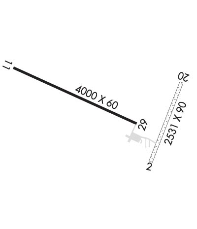
Runway Identifications
Runway Identification: 02/20Length: 2424 ft
Width: 90 ft
Surface: GRASS-GOOD CONDITION
Edge lights: Treatment: NONE
| | Runway: 02 | | Runway: 20 |
| Mag heading: | 22° | Mag heading: | 202° |
| Rwy Slope: | -1.01% Down | Rwy Slope: | 1.01% Up |
| Approach: | | Approach: | |
| Pattern: | Left Traffic | Pattern: | Left Traffic |
| Markings: | | Markings: | |
| Marking Condition: | MKD WITH YELLOW CONES. | Marking Condition: | MKD WITH YELLOW CONES. |
| Arresting Dev: | | Arresting Dev: | |
| Lat & Long: | N4334.5 W09053.6 | Lat. & Long.: | N4334.9 W09053.4 |
| Elev: | 1282.7 ft. MSL | Elev: | 1258.3 ft. MSL |
| TCH: | | TCH: | |
| Visual Glide Path: | | Visual Glide Path: | |
| Displaced Threshold: | No | Displaced Threshold: | No |
| Touchdown Zone: | YES | Touchdown Zone: | YES |
| Touchdown Elev.: | 1284.0 feet | Touchdown Elev.: | 1284.0 feet |
| Visual Glide Slope: | | Visual Glide Slope: | |
| RVR Equipment: | | RVR Equipment: | |
| RVV Equipment: | NO | RVV Equipment: | NO |
| Approach Lights: | | Approach Lights: | |
| REIL: | NO | REIL: | NO |
| Centerline Lights: | NO | Centerline Lights: | NO |
| Touchdown lights: | NO | Touchdown lights: | NO |
| Runway Category: | Runway with a Visual Approach | Runway Category: | Runway with a Visual Approach |
| Declared Distances: | | Declared Distances: | |
Runway Identification: 11/29Length: 4000 ft
Width: 60 ft
Surface: ASPHALT
Edge lights: Medium IntensityTreatment: NONE
| | Runway: 11 | | Runway: 29 |
| Mag heading: | 114° | Mag heading: | 294° |
| Rwy Slope: | .71% Up | Rwy Slope: | -.71% Down |
| Approach: | | Approach: | |
| Pattern: | Left Traffic | Pattern: | Left Traffic |
| Markings: | NONPRECISION INSTRUMENT | Markings: | NONPRECISION INSTRUMENT |
| Marking Condition: | GOOD | Marking Condition: | GOOD |
| Arresting Dev: | | Arresting Dev: | |
| Lat & Long: | N4335.0 W09054.5 | Lat. & Long.: | N4334.7 W09053.7 |
| Elev: | 1263.0 ft. MSL | Elev: | 1291.5 ft. MSL |
| TCH: | 35 ft. AGL | TCH: | 37 ft. AGL |
| Visual Glide Path: | 3.00 degrees | Visual Glide Path: | 3.00 degrees |
| Displaced Threshold: | No | Displaced Threshold: | No |
| Touchdown Zone: | YES | Touchdown Zone: | YES |
| Touchdown Elev.: | 1284.3 feet | Touchdown Elev.: | 1291.7 feet |
| Visual Glide Slope: | 2-Light PAPI on LEFT side of Runway | Visual Glide Slope: | 2-Light PAPI on LEFT side of Runway; RY 29 PAPI UNUSBL BYD 5 DEG L OF CNTRLN. |
| RVR Equipment: | | RVR Equipment: | |
| RVV Equipment: | NO | RVV Equipment: | NO |
| Approach Lights: | | Approach Lights: | |
| REIL: | YES | REIL: | YES |
| Centerline Lights: | NO | Centerline Lights: | NO |
| Touchdown lights: | NO | Touchdown lights: | NO |
| Runway Category: | Runway with a Visual Approach | Runway Category: | Runway with a Non-precision Approach |
| Declared Distances: | | Declared Distances: | |
| Comments: | 6 FT SIGN 50 FT FM THLD; 160 FT L. | Comments: | |

