Current Weather/Notams (Metars, TAFs, Notams, NWS Forecast, PIREPS, and nearby weather)
Customs Information Send updates to Support@FltPlan.com
Customs Not Available
Database effective 04/18/2024
Airport Diagram might not be current.
|
| Facility Name: | OAKLAND SOUTHWEST |
| City Name: | NEW HUDSON |
| County: | OAKLAND |
| State abbrev: | MI |
| State Name: | MICHIGAN |
| | |
| Ownership: | PUBLICLY OWNED |
| Use: | OPEN TO THE PUBLIC |
| Owner's Name: | OAKLAND COUNTY |
| Address: | 57751 PONTIAC TRL |
| | NEW HUDSON, MI 48165-8700 |
| Owner's Phone: | 248-437-2333 |
| | |
| Manager's Name: | CHERYL BUSH |
| Address: | 57751 PONTIAC TRL |
| | NEW HUDSON, MI 48165-8700 |
| Phone: | 248-666-3900 |
| | |
| FAA Region: | GREAT LAKES |
| FAA Field Office: | DET |
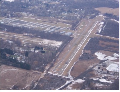
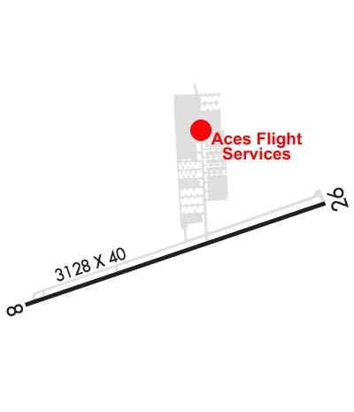
Runway Identifications
Runway Identification: 08/26Length: 3128 ft
Width: 40 ft
Surface: ASPHALT
Edge lights: Low IntensityTreatment: NONE
| | Runway: 08 | | Runway: 26 |
| Mag heading: | 78° | Mag heading: | 258° |
| Rwy Slope: | .17% Up | Rwy Slope: | -.17% Down |
| Approach: | | Approach: | |
| Pattern: | Left Traffic | Pattern: | Left Traffic |
| Markings: | BASIC | Markings: | BASIC |
| Marking Condition: | GOOD | Marking Condition: | GOOD |
| Arresting Dev: | | Arresting Dev: | |
| Lat & Long: | N4230.1 W08337.8 | Lat. & Long.: | N4230.3 W08337.1 |
| Elev: | 920.9 ft. MSL | Elev: | 926.1 ft. MSL |
| TCH: | 20 ft. AGL | TCH: | 19 ft. AGL |
| Visual Glide Path: | 4.00 degrees | Visual Glide Path: | 4.00 degrees |
| Displaced Threshold: | 867 feet | Displaced Threshold: | 864 feet |
| Touchdown Zone: | YES | Touchdown Zone: | YES |
| Touchdown Elev.: | 926.1 feet | Touchdown Elev.: | 926.1 feet |
| Visual Glide Slope: | 2-Box VASI on RIGHT side of Runway | Visual Glide Slope: | 2-Box VASI on LEFT side of Runway |
| RVR Equipment: | | RVR Equipment: | |
| RVV Equipment: | NO | RVV Equipment: | NO |
| Approach Lights: | | Approach Lights: | |
| REIL: | NO | REIL: | NO |
| Centerline Lights: | NO | Centerline Lights: | NO |
| Touchdown lights: | NO | Touchdown lights: | NO |
| Runway Category: | Runway with a Visual Approach | Runway Category: | Runway with a Visual Approach |
| Declared Distances: | | Declared Distances: | |
| Obstructions: | BRUSH | Obstructions: | TREES |
| Marked: | NOT Marked/Lighted | Marked: | NOT Marked/Lighted |
| Clearance slope: | 1:1; APCH RATIO 2:1 TO DTHR OVR 22 FT TREE, 62 FT DIST, 125 FT R. | Clearance slope: | 1:1; APCH RATIO 0:1 TO DTHR OVR 12 FT TREE, 0 FT DIST, 115 FT L. |
| Obstruction height: | 10 feet AGL | Obstruction height: | 73 feet AGL |
| Dist. from runway: | 200 feet | Dist. from runway: | 200 feet |
| Centerline offset: | 125 right of centerline | Centerline offset: | 125 feet right of centerline |
| Comments: | -4 FT DITCH, 40 FT DIST; SCATTERED 5-30 FT TREES & BRUSH, 0-199 FT DIST, 125 FT L & R. | Comments: | 15-40 FT TREES & BRUSH, 0-90 FT DIST, 110 FT L. |