Click here for more info on on SMS!

KY19

MANDAN MUNICIPAL
MANDAN
ND
Time Zone: Central
Lat: N 4646.1
Long: W 10053.7
Elev: 1944
Var: -06
Longest Runway: 4399
AWOS: 118.22
CTAF: 122.8

FBO & Flight Services info for KY19

FBOs: Update your Fuel Prices

MANDAN AVIATIONPh: 701-495-7391 Fax: 701-222-8945 Freq: 122.8
Service
Jet
100LL
SAF
MoGas
Fuel Avail: ~~RENTAL AND MAINT ONLY
Full        Last Update: 04/25/2024 05:27:31

Self        
 Address: US HIGHWAY 6,   MANDAN, ND 58554
MANDAN AIRPORTPh: 701-663-0669 Fax: 701-663-0669 Freq: 122.8
Service
Jet
100LL
SAF
MoGas
Fuel Avail: 24 HR 100LL SS / 48 HR NOTICE JET A
Full4.80      Last Update: 04/23/2024 14:09

Please call ahead for Jet fuel service
Self  5.35    
MANDAN AERO CTRPh: 701-663-9925
-
-
Service
Jet
100LL
SAF
MoGas
Fuel Avail: ~~MAINTENANCE ONLY.
Full        Last Update: 04/25/2024 05:27:31

Self        
AWOSPh: 701-663-0271
-
Freq: 118.22  
If you are an FBO, call 1-203-262-1700 to update your info or email: FltPlan.Advertising@garmin.com
Advertise your FBO on FltPlan.com

Runway & Approach Info for KY19
Rwy
Length
Land Dist**
Approach*
  Rwy
Length
Land Dist**
Approach*
04
2921x140  2921'          
 
  
22
  2921x140  2921'          
 
13
4399x75  4399'          
 
  
31
  4399x75  4399'          
 
 * only ILS, LOC, LDA, and SDF approaches to a specific runway are shown
** For any Declared Landing Distance Available, please see A/FD or Approach plates
Runway Weight Capability (lbs.) Help
Runway IDSingle WheelDouble WheelDouble Tandem WheelDual Double Wheel
04/22N/AN/AN/AN/A
13/3112,500N/AN/AN/A
These numbers are Advisory and are not limits.   The Airport Manager should have more accurate Weight Limits
Approach Charts
Approaches    
Current Weather/Notams
Customs Information Send updates to Support@FltPlan.com
Customs Not Available
Database effective 05/16/2024
Airport Diagram of KY19
Airport Diagram might not be current.

Facility Name: MANDAN RGNL/LAWLER FLD
City Name: MANDAN
County: MORTON
State abbrev: ND
State Name: NORTH DAKOTA
   
Ownership: PUBLICLY OWNED
Use: OPEN TO THE PUBLIC
Owner's Name: MANDAN ARPT AUTHORITY
Address: BOX 250
 MANDAN, ND 58554
Owner's Phone: 701-663-0669
  
Manager's Name: LINDSAY GERHARDT; AMGR CELL PHONE 701-955-3328.
Address: BOX 250
 MANDAN, ND 58554
Phone: 701-663-0669
   
FAA Region: GREAT LAKES
FAA Field Office: DMA


Sunrise / Sunset times for MANDAN RGNL/LAWLER FLD

DateSunriseSunset
04/24/24 Wednesday6:3920:45
04/25/24 Thursday6:3720:47
04/26/24 Friday6:3520:48
04/27/24 Saturday6:3420:49
04/28/24 Sunday6:3220:51
04/29/24 Monday6:3020:52
04/30/24 Tuesday6:2920:53
05/01/24 Wednesday6:2720:55
05/02/24 Thursday6:2620:56
05/03/24 Friday6:2420:57
05/04/24 Saturday6:2320:59
05/05/24 Sunday6:2121:00
05/06/24 Monday6:2021:01
05/07/24 Tuesday6:1821:02

Airport Facilities

Airport Attendance ScheduleMON-FRI 0700-1900, SAT-SUN ON CALL
Airport Status OPERATIONAL (This Status can change at any time - please check NOTAMS)
Airport Lighting ScheduleMIRL RY 13/31 & RY 04/22 PRESET ON MED TO INCR INTST & ACTVT - CTAF; ACTVT REIL RY 13/31; & PAPI RY 13/31 - CTAF.
Airport Storage AvailableTie Downs, Hanger
Extra Services AvailableCrop Dusting, Charter, Flight Instruction, Aircraft Rental, Aircraft Sales
Wind IndicatorYES - (lighted)
Control TowerNO
CTAF Frequency122.800
Unicom Frequency122.800
Rotating Beacon ColorWG
Segmented CircleYES
Landing FeeNO

Airport Inspection Data

Airport InspectedSTATE - performed by STATE AERONAUTICAL PERSONNEL
Inspection Date07/12/2021

Airport Services

Type of Fuel AvailableGrade 100LL, JET A (freeze point -40C); -10FOR 100LL FUEL 24 HR SELF SVC WITH CREDIT CARD OR CALL AMGR CELL PHONE 701-955-3328.; -A FOR JET A FUEL CONTACT AMGR CELL PHONE 701-955-3328.
Airframe Repair ServiceMAJOR
Power Plant Repair ServiceMAJOR

Geographic Data

LatitudeN4646.1
LongitudeW10053.7 (ESTIMATED)
Arpt Elevation1944ft (SURVEYED)
Magnetic Variation06E
4 miles Sof MANDAN
Traffic Pattern Altitude
Sectional ChartTWIN CITIES

Aircraft Data

Operations (Reported)YearlyAvg. Daily
General Aviation Transient 900025
General Aviation Local 1600044
Air Taxi 11003
Commerical 00
Commuter 00
Military 6002
Aircraft based on Field
General Aviation Singles 90
General Aviation Multi 5
Jet Aircraft 1
General Aviation Helicopters 4
Military Aircraft 0
Gliders 0
Ultralights 0

FAA Services

FSS on field NO
FSS tie-in GRAND FORKS
FSS Phone 1-800-WX-BRIEF
Who issues Notams GFK
Notam D service at airport YES
ARTCC Name MINNEAPOLIS

Federal Status

Airport Certification
Aircraft Rescue & Firefighting IndexNone
Airport of EntryNo
Custom Landing RightsNo
Joint Civil/MilitaryNo
Military Landing rightsYES

Federal Agreements

NATIONAL PLAN OF INTEGRATED AIRPORT SYSTEMS (NPIAS)
GRANT AGREEMENTS UNDER FAAP/ADAP/AIP
ASSURANCES PURSUANT TO TITLE VI, CIVIL RIGHTS ACT OF 1964

Remarks

CFM SN REMOVAL AFT MAJOR WINT STORMS WITH AMGR 701-663-0669 OR 701-955-3328.
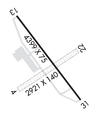
+200 FT TWR LCTD 9500 FT NW OF RWY 13/31.
120 FT TWR LCTD 5000 FT SW OF RWY 04/22.
FOR CD CTC BISMARCK APCH AT 701-223-8790.
Airport Communications & Frequencies:
CTAF Frequency:
122.800
Unicom Frequency:
122.800
Remarks
  • APCH/DEP SVC PRVDD BY MINNEAPOLIS ARTCC ON FREQS 135.25/256.7 (WOODWORTH RCAG) WHEN BISMARCK APCH CTL CLSD.
  • BISMARCK Primary Approach Frequencies:  
    126.3
    298.9
    BISMARCK Primary Departure Frequencies:  
    126.3
    298.9
    Runway Identifications
    Runway Identification: 04/22
    Length: 2921 ft
    Width: 140 ft
    Surface: GRASS-GOOD CONDITION
    Edge lights: Medium Intensity

    Treatment: NONE

     Runway: 04   Runway: 22
    Mag heading: 49°Mag heading: 229°
    Rwy Slope: .66% UpRwy Slope: -.66% Down
    Approach: Approach:
    Pattern: Left TrafficPattern: Left Traffic
    Markings: Markings:
    Marking Condition: Marking Condition:
    Arresting Dev: Arresting Dev:
    Lat & Long: N4645.9  W10054.0Lat. & Long.: N4646.1  W10053.4
    Elev: 1924.2 ft. MSLElev: 1943.4 ft. MSL
    TCH: TCH:
    Visual Glide Path: Visual Glide Path:
    Displaced Threshold: NoDisplaced Threshold: No
    Touchdown Zone: YESTouchdown Zone: YES
    Touchdown Elev.: 1943.6 feetTouchdown Elev.: 1943.6 feet
    Visual Glide Slope: Visual Glide Slope:
    RVR Equipment: RVR Equipment:
    RVV Equipment: NORVV Equipment: NO
    Approach Lights: Approach Lights:
    REIL: NOREIL: NO
    Centerline Lights: NOCenterline Lights: NO
    Touchdown lights: NOTouchdown lights: NO
    Runway Category: Runway with a Visual ApproachRunway Category: Runway with a Visual Approach
    Declared Distances: Declared Distances:
    Runway Identification: 13/31
    Length: 4399 ft
    Width: 75 ft
    Surface: CONCRETE-GOOD CONDITION
    Edge lights: Medium Intensity

    Treatment: NONE

     Runway: 13   Runway: 31
    Mag heading: 139°Mag heading: 319°
    Rwy Slope: .02% UpRwy Slope: -.02% Down
    Approach: Approach:
    Pattern: Left TrafficPattern: Left Traffic
    Markings: NONPRECISION INSTRUMENTMarkings: NONPRECISION INSTRUMENT
    Marking Condition: GOODMarking Condition: GOOD
    Arresting Dev: Arresting Dev:
    Lat & Long: N4646.4  W10053.9Lat. & Long.: N4645.8  W10053.3
    Elev: 1942.0 ft. MSLElev: 1943.0 ft. MSL
    TCH: 25 ft. AGLTCH: 25 ft. AGL
    Visual Glide Path: 3.00 degreesVisual Glide Path: 3.00 degrees
    Displaced Threshold: NoDisplaced Threshold: No
    Touchdown Zone: YESTouchdown Zone: YES
    Touchdown Elev.: 1942.0 feetTouchdown Elev.: 1943.6 feet
    Visual Glide Slope: 2-Light PAPI on LEFT side of RunwayVisual Glide Slope: 2-Light PAPI on LEFT side of Runway
    RVR Equipment: RVR Equipment:
    RVV Equipment: NORVV Equipment: NO
    Approach Lights: Approach Lights:
    REIL: YESREIL: YES
    Centerline Lights: NOCenterline Lights: NO
    Touchdown lights: NOTouchdown lights: NO
    Runway Category: Runway with a Non-precision ApproachRunway Category: Runway with a Non-precision Approach
    Declared Distances: Declared Distances:
    C:1/P: