KXNX

MUSIC CITY EXECUTIVE
GALLATIN
TN
Time Zone: Central
Lat: N 3622.5
Long: W 08624.5
Elev: 583
Var: +02
Longest Runway: 6300
AWOS: 132.72
CTAF: 123.05

FBO & Flight Services info for KXNX

FBOs: Update your Fuel Prices

  click here  
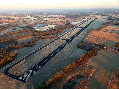
Located in Sumner County, 30 minutes northeast of downtown Nashville, Jet Access is a new alternate to the ever booming market of Middle Tennessee. Out of the hustle and bustle of Nashville International and John Tune Airport, Jet Access provides a convenience that its competition cannot. It is also the best valued FBO in the Nashville market.
Ph: 615-451-1490 Fax: 615-451-1464 Freq: 123.05WebsiteE-Mail
                             
Service
Jet
100LL
SAF
MoGas
Fuel Avail: Prist +$0.10; 6a-8p M-Su, 24-hour service available upon request
Full5.596.39    Last Update: 04/09/2024 13:30

Self  5.89    
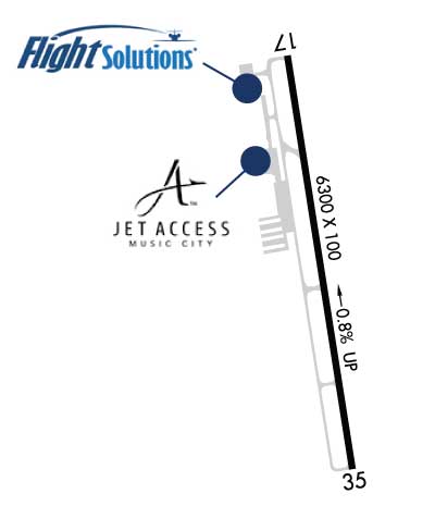
Misc. Info: We have 6300 feet for runway operations. 96K duel weightAddress: 1475 AIRPORT RD   GALLATIN, TN 37066

  click here  
Flight Solutions is a Full Service FBO located at KXNX.
Conveniently located just 20 miles north of Nashville, Music City Executive is quickly becoming the airport of choice for Nashville! Some of our services and amenities include: JetA fuel, hangar space, GPU, lav services, crew cars, rental cars, after hours, conference room upon request, and 100LL coming soon!
Ph: 615-452-5001
-
Freq: 131.07WebsiteE-Mail
                             
Service
Jet
100LL
SAF
MoGas
Fuel Avail: M-S 7 AM to 7 PM (after hours service available)
Full5.59      Last Update: 03/27/2024 11:52

Self        
Misc. Info: ASRI 131.075Address: 901 AIRPORT RD, HANGAR A-14   GALLATIN, TN 37066

AWOSPh: 615-230-8005
-
Freq: 132.72  
If you are an FBO, call 1-203-262-1700 to update your info or email: FltPlan.Advertising@garmin.com
Advertise your FBO on FltPlan.com

Runway & Approach Info for KXNX
Rwy
Length
Land Dist**
Approach*
  Rwy
Length
Land Dist**
Approach*
17
6300x100  6300'          
 
  
35
  6300x100  6300'          
 
 * only ILS, LOC, LDA, and SDF approaches to a specific runway are shown
** For any Declared Landing Distance Available, please see A/FD or Approach plates
Runway Weight Capability (lbs.) Help
Runway IDSingle WheelDouble WheelDouble Tandem WheelDual Double Wheel
17/3545,00096,000N/AN/A
These numbers are Advisory and are not limits.   The Airport Manager should have more accurate Weight Limits
Approach Charts
Approaches    
Current Weather/Notams
Customs Information Send updates to Support@FltPlan.com
Customs Not Available
Database effective 04/18/2024
Airport Diagram of KXNX
Airport Diagram might not be current.

Facility Name: MUSIC CITY EXEC
City Name: GALLATIN
County: SUMNER
State abbrev: TN
State Name: TENNESSEE
   
Ownership: PUBLICLY OWNED
Use: OPEN TO THE PUBLIC
Owner's Name: MUSIC CITY EXECUTIVE AIRPORT AUTH
Address: 1475 AIRPORT ROAD
 GALLATIN, TN 37066
Owner's Phone: 615-452-7248
  
Manager's Name: JEFF DUNHAM
Address: 1475 AIRPORT ROAD
 GALLATIN, TN 37066
Phone: (615) 452-7248
   
FAA Region: SOUTHERN
FAA Field Office: MEM


Sunrise / Sunset times for MUSIC CITY EXEC

DateSunriseSunset
04/18/24 Thursday6:0719:23
04/19/24 Friday6:0619:24
04/20/24 Saturday6:0519:25
04/21/24 Sunday6:0319:26
04/22/24 Monday6:0219:26
04/23/24 Tuesday6:0119:27
04/24/24 Wednesday6:0019:28
04/25/24 Thursday5:5819:29
04/26/24 Friday5:5719:30
04/27/24 Saturday5:5619:31
04/28/24 Sunday5:5519:32
04/29/24 Monday5:5419:32
04/30/24 Tuesday5:5319:33
05/01/24 Wednesday5:5219:34

Airport Facilities

Airport Attendance Schedule7 Days A Week 0700-1900
Airport Status OPERATIONAL (This Status can change at any time - please check NOTAMS)
Airport Lighting ScheduleACTVT REIL RWY 17 & 35; PAPI RWY 17 & 35; MIRL RWY 17/35 - CTAF.
Airport Storage AvailableTie Downs, Hanger
Extra Services AvailableCharter, Flight Instruction, Aircraft Rental, Aircraft Sales
Wind IndicatorYES - (unlit)
Control TowerNO
CTAF Frequency123.050
Unicom Frequency123.050
Rotating Beacon ColorWG
Segmented CircleYES
Landing FeeNO

Airport Inspection Data

Airport InspectedSTATE - performed by STATE AERONAUTICAL PERSONNEL
Inspection Date07/13/2021

Airport Services

Type of Fuel AvailableGrade 100LL, JET A (freeze point -40C)
Airframe Repair ServiceMAJOR
Power Plant Repair ServiceMAJOR

Geographic Data

LatitudeN3622.5
LongitudeW08624.5 (ESTIMATED)
Arpt Elevation583ft (SURVEYED)
Magnetic Variation02W
2 miles Eof GALLATIN
Traffic Pattern Altitude
Sectional ChartST LOUIS

Aircraft Data

Operations (Reported)YearlyAvg. Daily
General Aviation Transient 730020
General Aviation Local 2500068
Air Taxi 14004
Commerical 00
Commuter 00
Military 500
Aircraft based on Field
General Aviation Singles 64
General Aviation Multi 13
Jet Aircraft 17
General Aviation Helicopters 3
Military Aircraft 0
Gliders 0
Ultralights 0

FAA Services

FSS on field NO
FSS tie-in NASHVILLE
FSS Phone 1-800-WX-BRIEF
Who issues Notams BNA
Notam D service at airport YES
ARTCC Name MEMPHIS

Federal Status

Airport Certification
Aircraft Rescue & Firefighting IndexNone
Airport of EntryNo
Custom Landing RightsNo
Joint Civil/MilitaryNo
Military Landing rightsYES

Federal Agreements

NATIONAL PLAN OF INTEGRATED AIRPORT SYSTEMS (NPIAS)
GRANT AGREEMENTS UNDER FAAP/ADAP/AIP
ASSURANCES PURSUANT TO TITLE VI, CIVIL RIGHTS ACT OF 1964

Remarks

GCO AVBL ON FREQ 135.075 THRU NASHVILLE CD. IF UNA, FOR CD CTC NASHVILLE APCH AT 615-695-4522.
Airport Communications & Frequencies:
CTAF Frequency:
123.050
Unicom Frequency:
123.050
NASHVILLE Primary Approach Frequencies:  
118.4
360.7
NASHVILLE Primary Departure Frequencies:  
118.4
360.7
Runway Identifications
Runway Identification: 17/35
Length: 6300 ft
Width: 100 ft
Surface: ASPHALT
Edge lights: Medium Intensity

Treatment: NONE
Weight: PCN 27 /F/C/X/T

 Runway: 17   Runway: 35
Mag heading: 173°Mag heading: 353°
Rwy Slope: -.81% DownRwy Slope: .81% Up
Approach: Approach:
Pattern: Left TrafficPattern: Left Traffic
Markings: NONPRECISION INSTRUMENTMarkings: NONPRECISION INSTRUMENT
Marking Condition: GOODMarking Condition: GOOD
Arresting Dev: Arresting Dev:
Lat & Long: N3623.0  W08624.6Lat. & Long.: N3622.0  W08624.4
Elev: 583.3 ft. MSLElev: 532.5 ft. MSL
TCH: 28 ft. AGLTCH: 37 ft. AGL
Visual Glide Path: 3.00 degreesVisual Glide Path: 3.00 degrees
Displaced Threshold: NoDisplaced Threshold: No
Touchdown Zone: YESTouchdown Zone: YES
Touchdown Elev.: 583.3 feetTouchdown Elev.: 555.1 feet
Visual Glide Slope: 2-Light PAPI on LEFT side of Runway; UNUSBL BYD 5 DEGS RIGHT OF CNTRLN DUE TO OBST.Visual Glide Slope: 2-Light PAPI on LEFT side of Runway
RVR Equipment: RVR Equipment:
RVV Equipment: NORVV Equipment: NO
Approach Lights: Approach Lights:
REIL: YESREIL: YES
Centerline Lights: NOCenterline Lights: NO
Touchdown lights: NOTouchdown lights: NO
Runway Category: Runway with a Non-precision ApproachRunway Category: Runway with a Non-precision Approach
Declared Distances: Declared Distances:
Obstructions: TREESObstructions: TREE
Marked: NOT Marked/LightedMarked: NOT Marked/Lighted
Clearance slope: 13:1Clearance slope: 12:1
Obstruction height: 115 feet AGLObstruction height: 67 feet AGL
Dist. from runway: 1703 feetDist. from runway: 1008 feet
Centerline offset: 469 right of centerlineCenterline offset: 260 feet right of centerline
Comments: Comments:
C:22/P: