
| ||||||
| ||||||
|
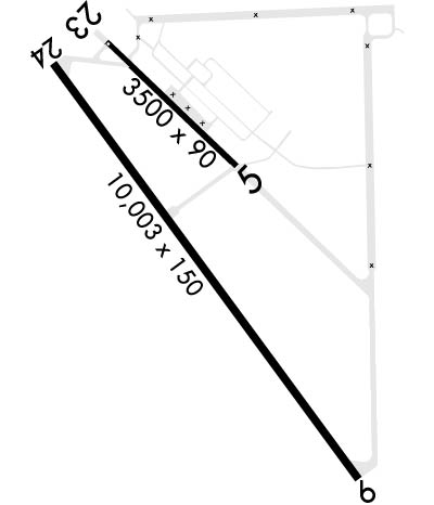
| Rwy | Rwy | |||||||
| 3500x90 | 3500' | 3500x90 | 3500' | |||||
| 10003x150 | 9003' | 10003x150 | 8999' | |||||
| Runway ID | Single Wheel | Double Wheel | Double Tandem Wheel | Dual Double Wheel |
| 051/231 | N/A | N/A | N/A | N/A |
| 06/24 | N/A | N/A | N/A | N/A |
| These numbers are Advisory and are not limits. The Airport Manager should have more accurate Weight Limits | ||||
 Airport Diagram might not be current. | |
| Facility Name: | NORTH AF AUX |
| City Name: | NORTH |
| County: | ORANGEBURG |
| State abbrev: | SC |
| State Name: | SOUTH CAROLINA |
| Ownership: | AIR FORCE OWNED |
| Use: | PRIVATE |
| Owner's Name: | USAF |
| Address: | SHAW AFB |
| SUMTER, SC 29152 | |
| Owner's Phone: | |
| Manager's Name: | NATHANIEL WATTS; AF BASE OPS POC. |
| Address: | NORTH AF AUX |
| NORTH, SC 29112 | |
| Phone: | 843-963-3028 |
| FAA Region: | SOUTHERN |
| FAA Field Office: | ATL |
| Date | Sunrise | Sunset |
|---|---|---|
| 04/23/24 Tuesday | 6:44 | 20:02 |
| 04/24/24 Wednesday | 6:42 | 20:03 |
| 04/25/24 Thursday | 6:41 | 20:03 |
| 04/26/24 Friday | 6:40 | 20:04 |
| 04/27/24 Saturday | 6:39 | 20:05 |
| 04/28/24 Sunday | 6:38 | 20:06 |
| 04/29/24 Monday | 6:37 | 20:07 |
| 04/30/24 Tuesday | 6:36 | 20:07 |
| 05/01/24 Wednesday | 6:35 | 20:08 |
| 05/02/24 Thursday | 6:34 | 20:09 |
| 05/03/24 Friday | 6:33 | 20:10 |
| 05/04/24 Saturday | 6:32 | 20:10 |
| 05/05/24 Sunday | 6:31 | 20:11 |
| 05/06/24 Monday | 6:30 | 20:12 |
| Airport Attendance Schedule | MON-THU 1430-0900, FRI 1430-2100, SAT-SUN CLSD; Z++. |
| Airport Status | OPERATIONAL (This Status can change at any time - please check NOTAMS) |
| Airport Lighting Schedule | ACTVT HIRL RWY 06/24 - 120.475/235.775.; ROTG BCN OFF DUR LGT OUT TRNG. |
| Airport Storage Available | NONE |
| Extra Services Available | NONE |
| Wind Indicator | NONE |
| Control Tower | NO |
| CTAF Frequency | |
| Unicom Frequency | |
| Rotating Beacon Color | WG |
| Segmented Circle | NO |
| Landing Fee |
| Airport Inspected | No Inspection Data Available performed by the OWNER |
| Inspection Date | Unknown |
| Type of Fuel Available | None |
| Airframe Repair Service | NONE |
| Power Plant Repair Service | NONE |
| Latitude | N3336.6 |
| Longitude | W08104.9 (ESTIMATED) |
| Arpt Elevation | 321ft (ESTIMATED) |
| Magnetic Variation | 07W |
| 0 miles | of NORTH |
| Traffic Pattern Altitude | TPA: RECTANGULAR 979 FT AGL / 1300 FT MSL, OVHD 1479 FT AGL / 1800 FT MSL. |
| Sectional Chart | CHARLOTTE |
| Operations (Reported) | Yearly | Avg. Daily |
|---|---|---|
| General Aviation Transient | 0 | 0 |
| General Aviation Local | 0 | 0 |
| Air Taxi | 0 | 0 |
| Commerical | 0 | 0 |
| Commuter | 0 | 0 |
| Military | 0 | 0 |
| Aircraft based on Field | |
|---|---|
| General Aviation Singles | 0 |
| General Aviation Multi | 0 |
| Jet Aircraft | 0 |
| General Aviation Helicopters | 0 |
| Military Aircraft | 0 |
| Gliders | 0 |
| Ultralights | 0 |
| FSS on field | NO |
| FSS tie-in | ANDERSON |
| FSS Phone | 1-800-WX-BRIEF |
| Who issues Notams | CHS |
| Notam D service at airport | YES |
| ARTCC Name | JACKSONVILLE |
| Airport Certification | |
| Aircraft Rescue & Firefighting Index | CAUTION: AERODROME ARFF AT REDUCED LVL OF SVC, USAF CAT 4 DUE TO VEH SHORTAGE, 6800 GAL AVBL. |
| Airport of Entry | No |
| Custom Landing Rights | No |
| Joint Civil/Military | No |
| Military Landing rights | No |
| REMARKS-RSTD TO OPR RSTD DUR BIRD WATCH COND MOD (TKOF OR LDG PERMS ONLY WHEN DEP/ARR RTE AVOID IDENT BIRD ACT, NO LCL IFR/VFR TFC PAT ATC) AND SEVERE (TKOF AND LDG PROH WO OG/GC APVL), CTC LZ/DZ OPS FAC FOR CURRENT BIRD WATCH COND. MIN 2 WK PRIOR COORD RQR FOR ALL USERS. |
| NS ABTMT: OVFT OF NORTH, SC PROH. |
| RSTD: TWY DELTA CLSD DURING BOX-IN-ONE OPS TO ALZ RWY 23. |
| RSTD: RWY 06 & 24 TKOF DIST AVBL 9000 FT, LDG DIST AVBL 8000 FT. |
| RWY COND CODE (RWYCC) NOT RPTD. |
| MISC: AN/FMQ-19 AUTOMATED OBERSVING SYS IN USE, NOT AUGMENTED BY HUMAN OBSN. PMSV RDO UNAVBL. PMSV/PHONE PATCH AVBL THRU 628 CP DSN 673-8400 C843-963-8400. MIL WX ADVSY/WNG/FCST UPDATES AVBL O/R VIA 437OSSS/OSW DSN 673-3016 C843-963-3016 DUR OPR HR 1100-0100Z++ MON-THU AND 100-2200Z++ FRI; CLSD WKEND, HOL, AND DOWN DAYS. MSN WX SPT FOR AIRCREW AVBL VIA THE 26 OWS/BARKSDALE AFB, DSN 331-2651 OR C318-529-2651 DUR MIL WX FLT CLOSURE HR. |
| CAUTION: ALZ RWY 05/23 NO DIST MKR PANELS. |
| CAUTION: MIL NVD OPS MAY BE CONDUCTED IN VCNTY OF AFLD ANYTIME BTN SS AND SR. |
| MISC: IF UNABLE TO CTC XNO LZ/DZ OPS FACILITY ON UHF/VHF CTC VIA FONE C843-670-6664. |
| REMARKS-RSTD - ALL AIRCREWS WILL CTC LZ/DZ ON 120.475/ 235.775 PRIOR TO 5 NM FROM NORTH AF AUX. LZ/DZ OPS FAC OPR 1430-0900Z ++ MON-THU; OPR 1430-2100++ FRI. CLSD SAT-SUN & FED HOL. |
| COMM/NAV/WEATHER REMARKS: ASOS 118.525 LCTD AT ORANGEBURG MUNI (KOGB). |
| LZ/DZ OPS FAC LTD TO ADVSY SVC ONLY, NO ATC SVCS PRVDD, AIRCREWS WILL CTC COLUMBIA APP TO REQ/ACTVT IFR CLNC. |
| CAUTION: AERODROME ARFF AT REDUCED LVL OF SVC, USAF CAT 4 DUE TO VEH SHORTAGE, 6800 GAL AVBL. |
| FOR CD CTC COLUMBIA APCH AT 803-822-5242 OR 803-822-5040. |
| RSTD: RWY 06-24 DEP: 9000 FT AVBL. BE AB PRIOR TO OPPOSITE END DSPLCD THR. DO NOT USE OPPOSITE END DSPLCD THR DIST FOR TKOF COMPUTATIONS. |
| SEE FLIP AP/1 SUPPLRY ARPT |
| CAUTION: INTS HVY MIL JET AND MISC ACFT EXCTNG NMRS CARGO AND PERS DROPS, HI-SPEED LO-LEVEL FORMATION FLT, AND AIRLAND OPR. RWY 06-24 NW TREE LINE 750 FT FR RWY CNTRLN. |
| CAUTION: RWY 06-24 LARGE DITCH 350 FT FR RWY CNTRLN AT MIDFIELD ON NW SIDE RWY. INTS GND TRNG ON RSVN. RWY 05-23 USED AS ASSAULT LDG ZONE (ALZ) 3500 FT X 90 FT. |
| RSTD: POC IS CHARLESTON AFB, 437 OSS/OSO, DSN 673-5554, C843-963-5554. ALL AIRCREWS WILL CTC NORTH DZ ON 120.75 OR 235.775 PRIOR TO 5 NM TO NORTH AF AUX. THIS ASP IS SUBJ TO BE RSTD BY NOTAM. RWY 06-24, NO 180 DEG STAR TURNS ON ASPH, CONDUCT ALL TURNS ON CONC ENDS. |
| MISC: ALZ RWY 05-23 AND 06-24 GROOVED. LZ/DZ OPS FACILITY LTD TO ADVSY SVC ONLY, NO ATC SVCS PRVDD, AIRCREWS WILL CTC COLUMBIA APP TO REQ/ACTVT IFR CLNC. |
| Runway: 051 | Runway: 231 | ||
| Mag heading: | N/A | Mag heading: | N/A |
| Rwy Slope: | .81% Up | Rwy Slope: | -.81% Down |
| Approach: | Approach: | ||
| Pattern: | Left Traffic | Pattern: | Left Traffic |
| Markings: | Markings: | ||
| Marking Condition: | Marking Condition: | ||
| Arresting Dev: | Arresting Dev: | ||
| Lat & Long: | N3336.4 W08104.6 | Lat. & Long.: | N3336.9 W08104.2 |
| Elev: | 292.7 ft. MSL | Elev: | 321.1 ft. MSL |
| TCH: | TCH: | ||
| Visual Glide Path: | Visual Glide Path: | ||
| Displaced Threshold: | No | Displaced Threshold: | No |
| Touchdown Zone: | YES | Touchdown Zone: | YES |
| Touchdown Elev.: | 292.8 feet | Touchdown Elev.: | 320.7 feet |
| Visual Glide Slope: | Visual Glide Slope: | ||
| RVR Equipment: | RVR Equipment: | ||
| RVV Equipment: | NO | RVV Equipment: | NO |
| Approach Lights: | Approach Lights: | ||
| REIL: | NO | REIL: | NO |
| Centerline Lights: | NO | Centerline Lights: | NO |
| Touchdown lights: | NO | Touchdown lights: | NO |
| Runway Category: | Runway Category: | ||
| Declared Distances: | Declared Distances: |
| Runway: 06 | Runway: 24 | ||
| Mag heading: | N/A | Mag heading: | N/A |
| Rwy Slope: | .50% Up | Rwy Slope: | -.50% Down |
| Approach: | Approach: | ||
| Pattern: | Left Traffic | Pattern: | Left Traffic |
| Markings: | Markings: | ||
| Marking Condition: | Marking Condition: | ||
| Arresting Dev: | Arresting Dev: | ||
| Lat & Long: | N3336.1 W08105.8 | Lat. & Long.: | N3337.0 W08104.2 |
| Elev: | 266.0 ft. MSL | Elev: | 316.0 ft. MSL |
| TCH: | TCH: | ||
| Visual Glide Path: | Visual Glide Path: | ||
| Displaced Threshold: | 1000 feet | Displaced Threshold: | 1004 feet |
| Touchdown Zone: | YES | Touchdown Zone: | YES |
| Touchdown Elev.: | 281.0 feet | Touchdown Elev.: | 316.0 feet |
| Visual Glide Slope: | Visual Glide Slope: | ||
| RVR Equipment: | RVR Equipment: | ||
| RVV Equipment: | NO | RVV Equipment: | NO |
| Approach Lights: | Approach Lights: | ||
| REIL: | NO | REIL: | NO |
| Centerline Lights: | NO | Centerline Lights: | NO |
| Touchdown lights: | NO | Touchdown lights: | NO |
| Runway Category: | Runway Category: | ||
| Declared Distances: | Declared Distances: |
