Current Weather/Notams (Metars, TAFs, Notams, NWS Forecast, PIREPS, and nearby weather)
Customs Information Send updates to Support@FltPlan.com
Customs Not Available
Database effective 05/16/2024
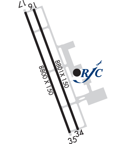
Airport Diagram might not be current. Facility Name: NORTHWEST ARKANSAS NTL City Name: FAYETTEVILLE/SPRINGDALE/ROGERS County: BENTON State abbrev: AR State Name: ARKANSAS Ownership: PUBLICLY OWNED Use: OPEN TO THE PUBLIC Owner's Name: NW ARKANSAS RGNL ARPT AUTH. Address: 1 AIRPORT BLVD, SUITE 100 BENTONVILLE, AR 72713 Owner's Phone: 479-205-1000 Manager's Name: ANDREW BRANCH Address: 1 AIRPORT BLVD, SUITE 100 BENTONVILLE, AR 72713 Phone: 479-205-1000 FAA Region: SOUTHWEST FAA Field Office: AOK
Runway Identifications Help
Runway Identification: 16L/34R Length: 8801 ftWidth: 150 ftSurface: CONCRETE-GOOD CONDITIONEdge lights: High Intensity Treatment: GROOVEDWeight: PCN 68 /R/B/W/T Runway: 16L Runway: 34R Mag heading: 159° Mag heading: 339° Rwy Slope: -.25% Down Rwy Slope: .25% Up Approach: ILS/DME Approach: ILS/DME Pattern: Left Traffic Pattern: Left Traffic Markings: PRECISION INSTRUMENT Markings: PRECISION INSTRUMENT Marking Condition: GOOD Marking Condition: GOOD Arresting Dev: Arresting Dev: Lat & Long: N3617.6 W09418.7 Lat. & Long.: N3616.2 W09418.1 Elev: 1287.0 ft. MSL Elev: 1264.6 ft. MSL TCH: 52 ft. AGL TCH: 51 ft. AGL Visual Glide Path: 3.00 degrees Visual Glide Path: 3.00 degrees Displaced Threshold: No Displaced Threshold: No Touchdown Zone: YES Touchdown Zone: YES Touchdown Elev.: 1287.0 feet Touchdown Elev.: 1273.3 feet Visual Glide Slope: 4-Light PAPI on LEFT side of Runway Visual Glide Slope: 4-Light PAPI on LEFT side of Runway RVR Equipment: TOUCHDOWN-ROLLOUT RVR Equipment: TOUCHDOWN-ROLLOUT RVV Equipment: NO RVV Equipment: NO Approach Lights: MALSR - 1,400 foot medium intensity approach lighting system with runway alignment indicator lights Approach Lights: MALSR - 1,400 foot medium intensity approach lighting system with runway alignment indicator lights REIL: NO REIL: NO Centerline Lights: NO Centerline Lights: NO Touchdown lights: NO Touchdown lights: NO Runway Category: Precision Instrument Runway Runway Category: Precision Instrument Runway Declared Distances: TORA:8800' TODA:8800' ASDA:8800' LDA:8800' Declared Distances: TORA:8800' TODA:8800' ASDA:8800' LDA:8800'
Runway Identification: 16R/34L Length: 8800 ftWidth: 150 ftSurface: CONCRETE-GOOD CONDITIONEdge lights: Medium Intensity Treatment: GROOVED Runway: 16R Runway: 34L Mag heading: 159° Mag heading: 339° Rwy Slope: -.26% Down Rwy Slope: .26% Up Approach: ILS/DME Approach: ILS/DME Pattern: Left Traffic Pattern: Left Traffic Markings: PRECISION INSTRUMENT Markings: PRECISION INSTRUMENT Marking Condition: GOOD Marking Condition: GOOD Arresting Dev: Arresting Dev: Lat & Long: N3617.6 W09418.8 Lat. & Long.: N3616.2 W09418.2 Elev: 1288.2 ft. MSL Elev: 1265.3 ft. MSL TCH: TCH: Visual Glide Path: Visual Glide Path: Displaced Threshold: No Displaced Threshold: No Touchdown Zone: YES Touchdown Zone: YES Touchdown Elev.: 1288.2 feet Touchdown Elev.: 1273.1 feet Visual Glide Slope: Visual Glide Slope: RVR Equipment: RVR Equipment: RVV Equipment: NO RVV Equipment: NO Approach Lights: Approach Lights: REIL: NO REIL: NO Centerline Lights: NO Centerline Lights: NO Touchdown lights: NO Touchdown lights: NO Runway Category: Precision Instrument Runway Runway Category: Precision Instrument Runway Declared Distances: TORA:8800' TODA:8800' ASDA:8800' LDA:8800' Declared Distances: TORA:8800' TODA:8800' ASDA:8800' LDA:8800'