Current Weather/Notams (Metars, TAFs, Notams, NWS Forecast, PIREPS, and nearby weather)
Customs Information Send updates to Support@FltPlan.com
Customs Not Available
Database effective 05/16/2024
Airport Diagram might not be current.
|
| Facility Name: | ARTHUR DUNN AIR PARK |
| City Name: | TITUSVILLE |
| County: | BREVARD |
| State abbrev: | FL |
| State Name: | FLORIDA |
| | |
| Ownership: | PUBLICLY OWNED |
| Use: | OPEN TO THE PUBLIC |
| Owner's Name: | TITUSVILLE -COCOA AIRPORT DISTRICT; CTC PERSON: KEVIN DAUGHERTY 321-267-8780. |
| Address: | 355 GOLDEN KNIGHTS BLVD |
| | TITUSVILLE, FL 32780 |
| Owner's Phone: | 321-267-8780 |
| | |
| Manager's Name: | KEVIN DAUGHERTY; FAX 321-383-4284 |
| Address: | 355 GOLDEN KNIGHTS BLVD. |
| | TITUSVILLE, FL 32780 |
| Phone: | 321-267-8780 |
| | |
| FAA Region: | SOUTHERN |
| FAA Field Office: | ORL |
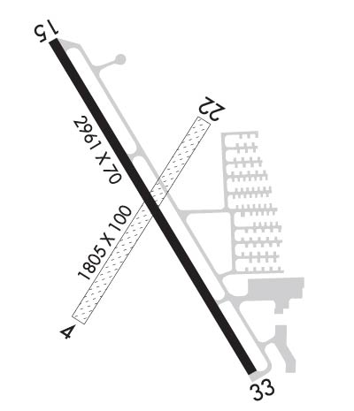
Runway Identifications
Runway Identification: 04/22Length: 1805 ft
Width: 100 ft
Surface: GRASS-GOOD CONDITION
Edge lights: Treatment: NONE
| | Runway: 04 | | Runway: 22 |
| Mag heading: | 37° | Mag heading: | 217° |
| Rwy Slope: | -.13% Down | Rwy Slope: | .13% Up |
| Approach: | | Approach: | |
| Pattern: | Left Traffic | Pattern: | Left Traffic |
| Markings: | NONSTANDARD | Markings: | NONSTANDARD |
| Marking Condition: | GOOD; RWY 04/22 MKD WITH W CONES. | Marking Condition: | GOOD; RWY 04/22 MKD WITH W CONES. |
| Arresting Dev: | | Arresting Dev: | |
| Lat & Long: | N2837.2 W08050.2 | Lat. & Long.: | N2837.5 W08050.0 |
| Elev: | 27.5 ft. MSL | Elev: | 25.2 ft. MSL |
| TCH: | | TCH: | |
| Visual Glide Path: | | Visual Glide Path: | |
| Displaced Threshold: | 100 feet | Displaced Threshold: | 297 feet |
| Touchdown Zone: | YES | Touchdown Zone: | YES |
| Touchdown Elev.: | 27.5 feet | Touchdown Elev.: | 25.2 feet |
| Visual Glide Slope: | | Visual Glide Slope: | |
| RVR Equipment: | | RVR Equipment: | |
| RVV Equipment: | NO | RVV Equipment: | NO |
| Approach Lights: | | Approach Lights: | |
| REIL: | NO | REIL: | NO |
| Centerline Lights: | NO | Centerline Lights: | NO |
| Touchdown lights: | NO | Touchdown lights: | NO |
| Runway Category: | Runway with a Visual Approach | Runway Category: | Runway with a Visual Approach |
| Declared Distances: | | Declared Distances: | |
| Obstructions: | TREE | Obstructions: | TREE |
| Marked: | NOT Marked/Lighted | Marked: | NOT Marked/Lighted |
| Clearance slope: | 17:1; RY 04 APCH RATIO 20:1 TO DSPLCD THLD. | Clearance slope: | 14:1; RY 22 APCH RATIO 20:1 TO DSPLCD THLD. |
| Obstruction height: | 34 feet AGL | Obstruction height: | 55 feet AGL |
| Dist. from runway: | 580 feet | Dist. from runway: | 794 feet |
| Centerline offset: | 26 left of centerline | Centerline offset: | 80 feet right of centerline |
| Comments: | | Comments: | |
Runway Identification: 15/33Length: 2961 ft
Width: 70 ft
Surface: ASPHALT-GOOD CONDITION
Edge lights: Medium IntensityTreatment: NONE
Weight: PCN 13 /F/B/X/T
| | Runway: 15 | | Runway: 33 |
| Mag heading: | 154° | Mag heading: | 334° |
| Rwy Slope: | .17% Up | Rwy Slope: | -.17% Down |
| Approach: | | Approach: | |
| Pattern: | Left Traffic | Pattern: | Left Traffic |
| Markings: | NONPRECISION INSTRUMENT | Markings: | NONPRECISION INSTRUMENT |
| Marking Condition: | GOOD | Marking Condition: | GOOD |
| Arresting Dev: | | Arresting Dev: | |
| Lat & Long: | N2837.6 W08050.3 | Lat. & Long.: | N2837.2 W08050.0 |
| Elev: | 24.2 ft. MSL | Elev: | 29.2 ft. MSL |
| TCH: | 45 ft. AGL | TCH: | 45 ft. AGL |
| Visual Glide Path: | 3.75 degrees | Visual Glide Path: | 3.75 degrees |
| Displaced Threshold: | No | Displaced Threshold: | 429 feet |
| Touchdown Zone: | YES | Touchdown Zone: | YES |
| Touchdown Elev.: | 30.0 feet | Touchdown Elev.: | 30.0 feet |
| Visual Glide Slope: | 2-Light PAPI on LEFT side of Runway | Visual Glide Slope: | 2-Light PAPI on LEFT side of Runway |
| RVR Equipment: | | RVR Equipment: | |
| RVV Equipment: | NO | RVV Equipment: | NO |
| Approach Lights: | | Approach Lights: | |
| REIL: | NO | REIL: | NO |
| Centerline Lights: | NO | Centerline Lights: | NO |
| Touchdown lights: | NO | Touchdown lights: | NO |
| Runway Category: | Runway with a Visual Approach | Runway Category: | Runway with a Visual Approach |
| Declared Distances: | | Declared Distances: | |
| Obstructions: | POLE | Obstructions: | TREES |
| Marked: | LIGHTED | Marked: | NOT Marked/Lighted |
| Clearance slope: | 17:1 | Clearance slope: | 7:1; RY 33 APCH RATIO 20:1 TO DSPLCD THLD. |
| Obstruction height: | 51 feet AGL | Obstruction height: | 55 feet AGL |
| Dist. from runway: | 1115 feet | Dist. from runway: | 595 feet |
| Centerline offset: | 145 right of centerline | Centerline offset: | 105 feet left of centerline |
| Comments: | | Comments: | |

