Current Weather/Notams (Metars, TAFs, Notams, NWS Forecast, PIREPS, and nearby weather)
Customs Information Send updates to Support@FltPlan.com
Customs Not Available
Database effective 05/16/2024
Airport Diagram might not be current.
|
| Facility Name: | LA BELLE MUNI |
| City Name: | LA BELLE |
| County: | HENDRY |
| State abbrev: | FL |
| State Name: | FLORIDA |
| | |
| Ownership: | PUBLICLY OWNED |
| Use: | OPEN TO THE PUBLIC |
| Owner's Name: | HENDRY COUNTY; SHANE PARKER 863-675-5222. |
| Address: | 99 EAST COWBOY WAY |
| | LABELLE, FL 33975-1607 |
| Owner's Phone: | 863 675-5220 |
| | |
| Manager's Name: | NAOMI GILDE |
| Address: | 311 E COWBOY WAY |
| | LABELLE, FL 33935-1607 |
| Phone: | 863-675-1568 |
| | |
| FAA Region: | SOUTHERN |
| FAA Field Office: | ORL |
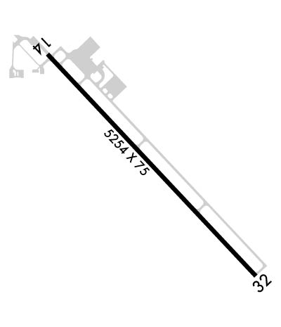
Runway Identifications
Runway Identification: 14/32Length: 5254 ft
Width: 75 ft
Surface: ASPHALT-GOOD CONDITION
Edge lights: Medium IntensityTreatment: NONE
Weight: PCN 20 /F/A/Y/T
| | Runway: 14 | | Runway: 32 |
| Mag heading: | 142° | Mag heading: | 322° |
| Rwy Slope: | .04% Up | Rwy Slope: | -.04% Down |
| Approach: | | Approach: | |
| Pattern: | Left Traffic | Pattern: | Left Traffic |
| Markings: | NONPRECISION INSTRUMENT | Markings: | NONPRECISION INSTRUMENT |
| Marking Condition: | FAIR | Marking Condition: | FAIR |
| Arresting Dev: | | Arresting Dev: | |
| Lat & Long: | N2644.8 W08126.0 | Lat. & Long.: | N2644.1 W08125.4 |
| Elev: | 18.1 ft. MSL | Elev: | 20.1 ft. MSL |
| TCH: | 40 ft. AGL | TCH: | 40 ft. AGL |
| Visual Glide Path: | 3.00 degrees | Visual Glide Path: | 3.00 degrees |
| Displaced Threshold: | 351 feet | Displaced Threshold: | 129 feet |
| Touchdown Zone: | YES | Touchdown Zone: | YES |
| Touchdown Elev.: | 19.3 feet | Touchdown Elev.: | 20.2 feet |
| Visual Glide Slope: | 4-Light PAPI on LEFT side of Runway | Visual Glide Slope: | 4-Light PAPI on LEFT side of Runway |
| RVR Equipment: | | RVR Equipment: | |
| RVV Equipment: | NO | RVV Equipment: | NO |
| Approach Lights: | | Approach Lights: | |
| REIL: | YES | REIL: | YES |
| Centerline Lights: | NO | Centerline Lights: | NO |
| Touchdown lights: | NO | Touchdown lights: | NO |
| Runway Category: | Runway with a Non-precision Approach having visibility minimums greater than 3/4 mile | Runway Category: | Runway with a Non-precision Approach having visibility minimums greater than 3/4 mile |
| Declared Distances: | | Declared Distances: | |
| Obstructions: | ROAD | Obstructions: | ROAD |
| Marked: | NOT Marked/Lighted | Marked: | NOT Marked/Lighted |
| Clearance slope: | 3:1; RWY 14, APCH RATIO 24:1 TO DTHR DUE TO 36 FT TREES 170 FT L OF CNTRLN 505 FT FM DTHR. | Clearance slope: | 11:1; RWY 32 APCH RATIO 34:1 TO DTHR. |
| Obstruction height: | 15 feet AGL | Obstruction height: | 15 feet AGL |
| Dist. from runway: | 257 feet | Dist. from runway: | 365 feet |
| Centerline offset: | 250 left of centerline | Centerline offset: | 250 feet right of centerline |
| Comments: | | Comments: | |

