Click here for more info on on SMS!

KX04

ORLANDO APOPKA
APOPKA
FL
Time Zone: Eastern
Lat: N 2842.4
Long: W 08134.9
Elev: 150
Var: +06
Longest Runway: 3987
CTAF: 123.05

FBO & Flight Services info for KX04

FBOs: Update your Fuel Prices

FIRST LANDINGSPh: 407-886-7612
-
Freq: 123.05
Service
Jet
100LL
SAF
MoGas
Full        Last Update: 04/06/2024 13:47

Self5.695.69    
 Address: 1321 APOPKA AIRPORT RD   APOPKA, FL 32712
If you are an FBO, call 1-203-262-1700 to update your info or email: FltPlan.Advertising@garmin.com
Advertise your FBO on FltPlan.com

Runway & Approach Info for KX04
Rwy
Length
Land Dist**
Approach*
  Rwy
Length
Land Dist**
Approach*
15
3987x60  3044'          
 
  
33
  3987x60  3987'          
 
 * only ILS, LOC, LDA, and SDF approaches to a specific runway are shown
** For any Declared Landing Distance Available, please see A/FD or Approach plates
Runway Weight Capability (lbs.) Help
Runway IDSingle WheelDouble WheelDouble Tandem WheelDual Double Wheel
15/33N/AN/AN/AN/A
These numbers are Advisory and are not limits.   The Airport Manager should have more accurate Weight Limits
Approach Charts
Approaches    
Current Weather/Notams
Customs Information Send updates to Support@FltPlan.com
Customs Not Available
Database effective 04/18/2024
Airport Diagram of KX04
Airport Diagram might not be current.

Facility Name: ORLANDO APOPKA
City Name: APOPKA
County: ORANGE
State abbrev: FL
State Name: FLORIDA
   
Ownership: PRIVATELY OWNED
Use: OPEN TO THE PUBLIC
Owner's Name: ORLANDO APOPKA ARPT CONDO ASSOC.
Address: 882 JACKSON AVE., REGISTERED AGENT
 WINTER PARK, FL 32789
Owner's Phone: 407-647-2622
  
Manager's Name: BOB JACKSON
Address: 1321 APOPKA AIRPORT RD HANGAR 37
 APOPKA, FL 32712
Phone: 407-308-5904
   
FAA Region: SOUTHERN
FAA Field Office: ORL


Sunrise / Sunset times for ORLANDO APOPKA

DateSunriseSunset
04/19/24 Friday6:5619:55
04/20/24 Saturday6:5519:56
04/21/24 Sunday6:5419:56
04/22/24 Monday6:5319:57
04/23/24 Tuesday6:5219:57
04/24/24 Wednesday6:5119:58
04/25/24 Thursday6:5019:59
04/26/24 Friday6:4919:59
04/27/24 Saturday6:4820:00
04/28/24 Sunday6:4720:00
04/29/24 Monday6:4620:01
04/30/24 Tuesday6:4620:02
05/01/24 Wednesday6:4520:02
05/02/24 Thursday6:4420:03

Airport Facilities

Airport Attendance Schedule7 Days A Week 0800-1800
Airport Status OPERATIONAL (This Status can change at any time - please check NOTAMS)
Airport Lighting SchedulePAPI 15 & 33 ON CONT DURG DALGT. AFTER SS, ACTVT PAPI RWY 15 & 33; LIRL RWY 15/33 - CTAF.
Airport Storage AvailableTie Downs, Hanger
Extra Services AvailableAvionics, Charter, Flight Instruction, Aircraft Rental, Aircraft Sales, Annual Surveying
Wind IndicatorYES - (lighted)
Control TowerNO
CTAF Frequency123.050
Unicom Frequency123.050
Rotating Beacon ColorWG
Segmented CircleY-L
Landing FeeNO

Airport Inspection Data

Airport InspectedSTATE - performed by STATE AERONAUTICAL PERSONNEL
Inspection Date08/17/2018

Airport Services

Type of Fuel AvailableGrade 100LL, JET A (freeze point -40C)
Airframe Repair ServiceMAJOR
Power Plant Repair ServiceMAJOR

Geographic Data

LatitudeN2842.4
LongitudeW08134.9 (ESTIMATED)
Arpt Elevation150ft (ESTIMATED)
Magnetic Variation06W
4 miles NWof APOPKA
Traffic Pattern Altitude
Sectional ChartJACKSONVILLE

Aircraft Data

Operations (Reported)YearlyAvg. Daily
General Aviation Transient 370010
General Aviation Local 2920080
Air Taxi 2501
Commerical 00
Commuter 00
Military 00
Aircraft based on Field
General Aviation Singles 196
General Aviation Multi 32
Jet Aircraft 3
General Aviation Helicopters 4
Military Aircraft 0
Gliders 2
Ultralights 12

FAA Services

FSS on field NO
FSS tie-in SAINT PETERSBURG
FSS Phone 1-800-WX-BRIEF
Who issues Notams PIE
Notam D service at airport YES
ARTCC Name JACKSONVILLE

Federal Status

Airport Certification
Aircraft Rescue & Firefighting IndexNone
Airport of EntryNo
Custom Landing RightsNo
Joint Civil/MilitaryNo
Military Landing rightsNo

Remarks

STEEP DROPOFF 63 FT FM SE END & APRXLY 60 FT OFF WEST & EAST EDGE.
RY 15/33 RR PENETRATES 7:1 TRANS SFC EAST SIDE.
CTC UNICOM OR 407-308-5904 FOR SAFETY BRIEFING.
RY 15/33 CLSD TO TOUCH AND GO LNDGS BY TRANSIENT HELICOPTERS.
FOR CD OR TO CNL IFR CTC ORLANDO APCH AT 407-852-7500.
ACTVT AUTOMATED UNICOM - CTAF
ACFT HLDG SHRT RWY 15 MAY BE UNA TO SEE ACFT ON FINAL FOR RWY 15.
Airport Communications & Frequencies:
CTAF Frequency:
123.050
Unicom Frequency:
123.050
ORLANDO Primary Approach Frequencies:  
135.3
351.9
ORLANDO Primary Departure Frequencies:  
135.3
351.9
Runway Identifications
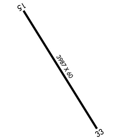
Runway Identification: 15/33
Length: 3987 ft
Width: 60 ft
Surface: ASPHALT-FAIR CONDITION
Edge lights: Low Intensity

Treatment: NONE

 Runway: 15   Runway: 33
Mag heading: N/AMag heading: N/A
Rwy Slope: -.43% DownRwy Slope: .43% Up
Approach: Approach:
Pattern: Right TrafficPattern: Left Traffic
Markings: BASICMarkings: BASIC
Marking Condition: FAIRMarking Condition: FAIR
Arresting Dev: Arresting Dev:
Lat & Long: N2842.7  W08135.1Lat. & Long.: N2842.2  W08134.7
Elev: 142.2 ft. MSLElev: 125.2 ft. MSL
TCH: 10 ft. AGLTCH: 25 ft. AGL
Visual Glide Path: 3.50 degreesVisual Glide Path: 3.00 degrees
Displaced Threshold: 943 feetDisplaced Threshold: No
Touchdown Zone: YESTouchdown Zone: YES
Touchdown Elev.: 150.0 feetTouchdown Elev.: 127.5 feet
Visual Glide Slope: 2-Light PAPI on LEFT side of RunwayVisual Glide Slope: 2-Light PAPI on LEFT side of Runway
RVR Equipment: RVR Equipment:
RVV Equipment: NORVV Equipment: NO
Approach Lights: Approach Lights:
REIL: NOREIL: NO
Centerline Lights: NOCenterline Lights: NO
Touchdown lights: NOTouchdown lights: NO
Runway Category: Runway with a Visual ApproachRunway Category: Runway with a Visual Approach
Declared Distances: TORA:3987' TODA:3987' ASDA:3987' LDA:3044'Declared Distances: TODA:3987' ASDA:3987' LDA:3987'
Obstructions: BERMObstructions: TREES
Marked: NOT Marked/LightedMarked: NOT Marked/Lighted
Clearance slope: 1:1; RY 15 APCH RATIO 20:1 FM DSPLCD THLD DUE TO 33 FT RR TRACK 420 FROM END OF RY 125 L OF CNTRLN.Clearance slope: 34:1
Obstruction height: 10 feet AGLObstruction height: 57 feet AGL
Dist. from runway: 200 feetDist. from runway: 2170 feet
Centerline offset: 125 left of centerlineCenterline offset: 150 feet left of centerline
Comments: RWY 15 HAS 10 FT BERM 200 FT FM RWY END 125 FT LEFT.Comments:
C:4/P: