
| ||||||||||||||||||||||||||||||||||||||||||||
| ||||||||||||||||||||||||||||||||||||||||||||
| ||||||||||||||||||||||||||||||||||||||||||||
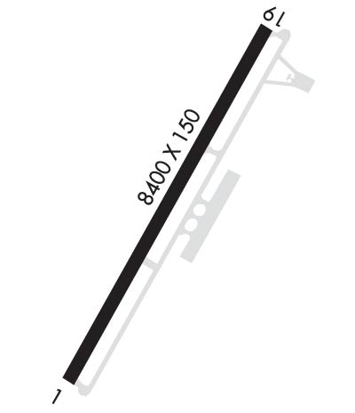
| Rwy | Rwy | |||||||
| 8400x150 | 8400' | 110.70 - 012° | 8400x150 | 8400' | ||||
| Runway ID | Single Wheel | Double Wheel | Double Tandem Wheel | Dual Double Wheel |
| 01/19 | 90,000 | 150,000 | 280,000 | N/A |
| These numbers are Advisory and are not limits. The Airport Manager should have more accurate Weight Limits | ||||
 Airport Diagram might not be current. | |
| Facility Name: | YELLOWSTONE |
| City Name: | WEST YELLOWSTONE |
| County: | GALLATIN |
| State abbrev: | MT |
| State Name: | MONTANA |
| Ownership: | PUBLICLY OWNED |
| Use: | OPEN TO THE PUBLIC |
| Owner's Name: | STATE OF MONTANA |
| Address: | PO BOX 200507 |
| HELENA, MT 59620 | |
| Owner's Phone: | 406-444-2506 |
| Manager's Name: | JEFF KADLEC |
| Address: | 721 AIRPORT RD., P.O. BOX 306 |
| WEST YELLOWSTONE, MT 59758-0306 | |
| Phone: | 406-646-7631; IF NO ANSWER CALL 406-459-9825/406-444-2506. |
| FAA Region: | NORTHWEST MOUNTAIN |
| FAA Field Office: | HLN |
| Date | Sunrise | Sunset |
|---|---|---|
| 04/22/24 Monday | 6:27 | 20:19 |
| 04/23/24 Tuesday | 6:26 | 20:21 |
| 04/24/24 Wednesday | 6:24 | 20:22 |
| 04/25/24 Thursday | 6:22 | 20:23 |
| 04/26/24 Friday | 6:21 | 20:24 |
| 04/27/24 Saturday | 6:19 | 20:25 |
| 04/28/24 Sunday | 6:18 | 20:27 |
| 04/29/24 Monday | 6:16 | 20:28 |
| 04/30/24 Tuesday | 6:15 | 20:29 |
| 05/01/24 Wednesday | 6:13 | 20:30 |
| 05/02/24 Thursday | 6:12 | 20:32 |
| 05/03/24 Friday | 6:10 | 20:33 |
| 05/04/24 Saturday | 6:09 | 20:34 |
| 05/05/24 Sunday | 6:08 | 20:35 |
| Airport Attendance Schedule | MAY-OCT 7 Days A Week 0800-1700; WEATHER DEPENDENT |
| Airport Status | OPERATIONAL (This Status can change at any time - please check NOTAMS) |
| Airport Lighting Schedule | ACTVT MALSR RWY 01; REIL RWY 19; HIRL RWY 01/19 - CTAF. PAPI RWY 01 & 19 OPR CONSLY. NOT AVBL 31 OCT- 7 MAY . |
| Airport Storage Available | Tie Downs |
| Extra Services Available | NONE |
| Wind Indicator | YES - (lighted) |
| Control Tower | NO |
| CTAF Frequency | 123.000 |
| Unicom Frequency | 123.000 |
| Rotating Beacon Color | WG |
| Segmented Circle | YES |
| Landing Fee | YES; LDG FEE FOR TURBINE PWRD ACFT. PISTON PWRD EXEMPT. |
| Airport Inspected | FEDERAL - performed by FAA AIRPORTS FIELD PERSONNEL |
| Inspection Date | 05/16/2023 |
| Type of Fuel Available | Grade 100LL, JET A-1 (icing inhibitor, freeze point -50C); -10FOR FUEL DURG OFF SEASON HRS CALL 406-646-7359. |
| Airframe Repair Service | NONE |
| Power Plant Repair Service | NONE |
| Latitude | N4441.3 |
| Longitude | W11107.1 (ESTIMATED) |
| Arpt Elevation | 6649ft (SURVEYED) |
| Magnetic Variation | 14E |
| 1 miles N | of WEST YELLOWSTONE |
| Traffic Pattern Altitude | |
| Sectional Chart | GREAT FALLS |
| Operations (Reported) | Yearly | Avg. Daily |
|---|---|---|
| General Aviation Transient | 8000 | 22 |
| General Aviation Local | 2500 | 7 |
| Air Taxi | 530 | 1 |
| Commerical | 0 | 0 |
| Commuter | 0 | 0 |
| Military | 75 | 0 |
| Aircraft based on Field | |
|---|---|
| General Aviation Singles | 2 |
| General Aviation Multi | 0 |
| Jet Aircraft | 0 |
| General Aviation Helicopters | 2 |
| Military Aircraft | 0 |
| Gliders | 0 |
| Ultralights | 0 |
| FSS on field | NO |
| FSS tie-in | GREAT FALLS |
| FSS Phone | 1-800-WX-BRIEF |
| Who issues Notams | WYS |
| Notam D service at airport | YES |
| ARTCC Name | SALT LAKE CITY |
| Airport Certification | AIRPORT RECEIVING SCHEDULED AIR CARRIER SERVICE FROM CARRIERS CERTIFICATED BY THE CIVIL AERONAUTICS BOARD; PPR FOR ACR OPNS WITH MORE THAN 30 PSGR SEATS CALL AMGR 406-646-7631 OR 406-459-9825. |
| Aircraft Rescue & Firefighting Index | AIRPORT HAS A CERTIFICATE UNDER CFR PART 139 |
| Airport of Entry | No |
| Custom Landing Rights | No |
| Joint Civil/Military | No |
| Military Landing rights | YES |
| NATIONAL PLAN OF INTEGRATED AIRPORT SYSTEMS (NPIAS) |
| GRANT AGREEMENTS UNDER FAAP/ADAP/AIP |
| CONVEYANCE UNDER SCETION 16, FEDERAL AIRPORT ACT OF 1946 OR SECTION 23, AIRPORT AND AIRWAY DEVELOPMENT ACT OF 1970 |
| ASSURANCES PURSUANT TO TITLE VI, CIVIL RIGHTS ACT OF 1964 |
| THIS AIRPORT HAS BEEN SURVEYED BY THE NATIONAL GEODETIC SURVEY. |
| NO SNOW REMOVAL. |
| HEAVY SNOWMOBILE USE ON/ADJACENT RY WINTER MOS. |
| ARPT CLSD OCT 31 THRU MAY1. CHK NOTAMS FOR OPS DATES OR CALL 406-459-9825/406-646-7631. |
| COLD TEMPERATURE AIRPORT. ALTITUDE CORRECTION REQUIRED AT OR BELOW -20C. |
| CONDITIONS UNMONITORED 1700-0800L DAILY. |
| FOR CD CTC SALT LAKE ARTCC AT 801-320-2568 . |
Airport Communications & Frequencies:
| |||||||||
| Runway: 01 | Runway: 19 | ||
| Mag heading: | 12° | Mag heading: | 192° |
| Rwy Slope: | -.17% Down | Rwy Slope: | .17% Up |
| Approach: | ILS | Approach: | |
| Pattern: | Left Traffic | Pattern: | Left Traffic |
| Markings: | PRECISION INSTRUMENT | Markings: | NONPRECISION INSTRUMENT |
| Marking Condition: | GOOD | Marking Condition: | GOOD |
| Arresting Dev: | Arresting Dev: | ||
| Lat & Long: | N4440.7 W11107.5 | Lat. & Long.: | N4441.9 W11106.6 |
| Elev: | 6648.8 ft. MSL | Elev: | 6634.2 ft. MSL |
| TCH: | 50 ft. AGL | TCH: | 53 ft. AGL |
| Visual Glide Path: | 3.00 degrees | Visual Glide Path: | 3.00 degrees |
| Displaced Threshold: | No | Displaced Threshold: | No |
| Touchdown Zone: | YES | Touchdown Zone: | YES |
| Touchdown Elev.: | 6648.8 feet | Touchdown Elev.: | 6638.1 feet |
| Visual Glide Slope: | 4-Light PAPI on LEFT side of Runway | Visual Glide Slope: | 4-Light PAPI on LEFT side of Runway |
| RVR Equipment: | RVR Equipment: | ||
| RVV Equipment: | NO | RVV Equipment: | NO |
| Approach Lights: | MALSR - 1,400 foot medium intensity approach lighting system with runway alignment indicator lights | Approach Lights: | |
| REIL: | NO | REIL: | YES |
| Centerline Lights: | NO | Centerline Lights: | NO |
| Touchdown lights: | NO | Touchdown lights: | NO |
| Runway Category: | Precision Instrument Runway | Runway Category: | Runway with a Non-precision Approach having visibility minimums greater than 3/4 mile |
| Declared Distances: | TORA:8400' TODA:8400' ASDA:8400' LDA:8400' | Declared Distances: | TORA:8400' TODA:8400' ASDA:8400' LDA:8400' |
