Click here for more info on on SMS!

KWWR

WEST WOODWARD
WOODWARD
OK
Time Zone: Central
Lat: N 3626.3
Long: W 09931.4
Elev: 2189
Var: -08
Longest Runway: 5502
AWOS: 118.42
CTAF: 122.8

FBO & Flight Services info for KWWR

FBOs: Update your Fuel Prices
The Woodward Airport offers such ammenities as wireless internet, route planning, WSI weather, and a pilot lounge open 7 days a week.
Ph: 580-256-8286 Fax: 580-256-2592 Freq: 122.8WebsiteE-Mail
Service
Jet
100LL
SAF
MoGas
Fuel Avail: PRIST PREMIXED. Surcharge after hours, closed Christmas and Thanksgiving Day
Full4.305.30    Last Update: 04/15/2024 10:20

FBO Hours 0800-1800 weekdays, 0800-1600 weekends
Self4.055.05    
Misc. Info: Jet-A contains Prist, FBO hours 0800-1800 weekdays, 0800-1600 weekendsAddress: 1301 AIR PARK RD,   WOODWARD, OK 73801

AWOSPh: 580-254-5217
-
Freq: 118.42  
If you are an FBO, call 1-203-262-1700 to update your info or email: FltPlan.Advertising@garmin.com
Advertise your FBO on FltPlan.com

Runway & Approach Info for KWWR
Rwy
Length
Land Dist**
Approach*
  Rwy
Length
Land Dist**
Approach*
05
2500x60  2500'          
 
  
23
  2500x60  2500'          
 
17
5502x100  5502'          
 
  
35
  5502x100  5502'          
 
 * only ILS, LOC, LDA, and SDF approaches to a specific runway are shown
** For any Declared Landing Distance Available, please see A/FD or Approach plates
Runway Weight Capability (lbs.) Help
Runway IDSingle WheelDouble WheelDouble Tandem WheelDual Double Wheel
05/23N/AN/AN/AN/A
17/3530,00060,000N/AN/A
These numbers are Advisory and are not limits.   The Airport Manager should have more accurate Weight Limits
Approach Charts
Approaches    
Current Weather/Notams
Customs Information Send updates to Support@FltPlan.com
Customs Not Available
Database effective 05/16/2024
Airport Diagram of KWWR
Airport Diagram might not be current.

Facility Name: WEST WOODWARD
City Name: WOODWARD
County: WOODWARD
State abbrev: OK
State Name: OKLAHOMA
   
Ownership: PUBLICLY OWNED
Use: OPEN TO THE PUBLIC
Owner's Name: CITY OF WOODWARD
Address: 722 MAIN ST.
 WOODWARD, OK 73801
Owner's Phone: 580-256-2280
  
Manager's Name: CHRIS AMES
Address: 1301 AIRPARK RD
 WOODWARD, OK 73801
Phone: 580-334-5786
   
FAA Region: SOUTHWEST
FAA Field Office: AOK


Sunrise / Sunset times for WEST WOODWARD

DateSunriseSunset
04/23/24 Tuesday6:5320:20
04/24/24 Wednesday6:5220:21
04/25/24 Thursday6:5120:22
04/26/24 Friday6:5020:22
04/27/24 Saturday6:4820:23
04/28/24 Sunday6:4720:24
04/29/24 Monday6:4620:25
04/30/24 Tuesday6:4520:26
05/01/24 Wednesday6:4420:27
05/02/24 Thursday6:4320:28
05/03/24 Friday6:4220:29
05/04/24 Saturday6:4120:29
05/05/24 Sunday6:4020:30
05/06/24 Monday6:3920:31

Airport Facilities

Airport Attendance ScheduleMON-FRI 0800-1800, SAT-SUN 0800-1600; UNATNDD SUN AND HOL.
Airport Status OPERATIONAL (This Status can change at any time - please check NOTAMS)
Airport Lighting ScheduleACTVT & INCR INTST ODALS RWY 17; REIL RWY 35; MIRL RWY 17/35, 05/23 - CTAF. PAPI RWY 17 & 35 24-HR PHOTO CELL.
Airport Storage AvailableTie Downs, Hanger
Extra Services AvailableAir Freight, Flight Instruction, Aircraft Rental
Wind IndicatorYES - (lighted)
Control TowerNO
CTAF Frequency122.800
Unicom Frequency122.800
Rotating Beacon ColorWG
Segmented CircleYES
Landing FeeNO

Airport Inspection Data

Airport InspectedSTATE - performed by STATE AERONAUTICAL PERSONNEL
Inspection Date07/11/2023

Airport Services

Type of Fuel AvailableGrade 100LL, JET A
Airframe Repair ServiceMINOR
Power Plant Repair ServiceMINOR

Geographic Data

LatitudeN3626.3
LongitudeW09931.4 (ESTIMATED)
Arpt Elevation2189ft (SURVEYED)
Magnetic Variation08E
6 miles Wof WOODWARD
Traffic Pattern Altitude
Sectional ChartWICHITA

Aircraft Data

Operations (Reported)YearlyAvg. Daily
General Aviation Transient 25007
General Aviation Local 350010
Air Taxi 00
Commerical 00
Commuter 00
Military 300
Aircraft based on Field
General Aviation Singles 21
General Aviation Multi 2
Jet Aircraft 2
General Aviation Helicopters 0
Military Aircraft 0
Gliders 0
Ultralights 0

FAA Services

FSS on field NO
FSS tie-in MC ALESTER
FSS Phone 1-800-WX-BRIEF
Who issues Notams WWR
Notam D service at airport YES
ARTCC Name KANSAS CITY

Federal Status

Airport Certification
Aircraft Rescue & Firefighting IndexNone
Airport of EntryNo
Custom Landing RightsNo
Joint Civil/MilitaryNo
Military Landing rightsYES

Federal Agreements

NATIONAL PLAN OF INTEGRATED AIRPORT SYSTEMS (NPIAS)
GRANT AGREEMENTS UNDER FAAP/ADAP/AIP
SURPLUS PROPERTY AGREEMENT UNDER PUBLIC LAW 289
SURPLUS PROPERTY AGREEMENT UNDER REGULATION 16-WAA
ASSURANCES PURSUANT TO TITLE VI, CIVIL RIGHTS ACT OF 1964

Remarks

ULTRALIGHT ACTIVITY ON & INVOF ARPT.
TETRAHEDRON OTS.
DEER & COYOTES ON & INVOF ARPT.
FOR CD CTC KANSAS CITY ARTCC AT 913-254-8508.
AFT HRS CTC 580-216-8233/ CALL OUT FEE.
24 HR. LOUNGE
SELF SVC FUEL AVBL 24/7.
Airport Communications & Frequencies:
CTAF Frequency:
122.800
Unicom Frequency:
122.800
Remarks
  • APCH/DEP CTL SVC PRVDD BY KANSAS CITY ARTCC (ZKC) ON FREQS 126.95/379.2 (GAGE RCAG).
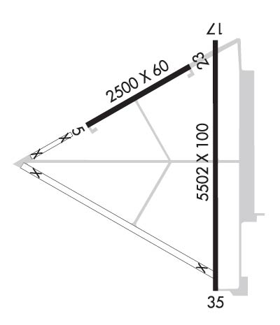
  • Runway Identifications
    Runway Identification: 05/23
    Length: 2500 ft
    Width: 60 ft
    Surface: ASPHALT-FAIR CONDITION
    Edge lights: Medium Intensity

    Treatment: NONE

     Runway: 05   Runway: 23
    Mag heading: 52°Mag heading: 232°
    Rwy Slope: -.10% DownRwy Slope: .10% Up
    Approach: Approach:
    Pattern: Left TrafficPattern: Right Traffic
    Markings: BASICMarkings: BASIC
    Marking Condition: POOR; MARKINGS FADED & OBSCD.Marking Condition: POOR; MARKINGS FADED & OBSCD.
    Arresting Dev: Arresting Dev:
    Lat & Long: N3626.3  W09931.8Lat. & Long.: N3626.6  W09931.4
    Elev: 2166.5 ft. MSLElev: 2164.1 ft. MSL
    TCH: TCH:
    Visual Glide Path: Visual Glide Path:
    Displaced Threshold: NoDisplaced Threshold: No
    Touchdown Zone: YESTouchdown Zone: YES
    Touchdown Elev.: 2168.5 feetTouchdown Elev.: 2168.5 feet
    Visual Glide Slope: Visual Glide Slope:
    RVR Equipment: RVR Equipment:
    RVV Equipment: NORVV Equipment: NO
    Approach Lights: Approach Lights:
    REIL: NOREIL: NO
    Centerline Lights: NOCenterline Lights: NO
    Touchdown lights: NOTouchdown lights: NO
    Runway Category: Runway with a Visual ApproachRunway Category: Runway with a Visual Approach
    Declared Distances: Declared Distances:
    Runway Identification: 17/35
    Length: 5502 ft
    Width: 100 ft
    Surface: CONCRETE-GOOD CONDITION
    Edge lights: Medium Intensity

    Treatment: NONE

     Runway: 17   Runway: 35
    Mag heading: 172°Mag heading: 352°
    Rwy Slope: .50% UpRwy Slope: -.50% Down
    Approach: Approach:
    Pattern: Left TrafficPattern: Left Traffic
    Markings: NONPRECISION INSTRUMENTMarkings: NONPRECISION INSTRUMENT
    Marking Condition: GOODMarking Condition: GOOD
    Arresting Dev: Arresting Dev:
    Lat & Long: N3626.7  W09931.3Lat. & Long.: N3625.7  W09931.3
    Elev: 2161.1 ft. MSLElev: 2188.8 ft. MSL
    TCH: 39 ft. AGLTCH: 40 ft. AGL
    Visual Glide Path: 3.00 degreesVisual Glide Path: 3.00 degrees
    Displaced Threshold: NoDisplaced Threshold: No
    Touchdown Zone: YESTouchdown Zone: YES
    Touchdown Elev.: 2176.0 feetTouchdown Elev.: 2189.0 feet
    Visual Glide Slope: 4-Light PAPI on LEFT side of RunwayVisual Glide Slope: 4-Light PAPI on LEFT side of Runway
    RVR Equipment: RVR Equipment:
    RVV Equipment: NORVV Equipment: NO
    Approach Lights: ODALS - omnidirectional approach lighting systemApproach Lights:
    REIL: NOREIL: YES
    Centerline Lights: NOCenterline Lights: NO
    Touchdown lights: NOTouchdown lights: NO
    Runway Category: Runway with a Non-precision Approach having visibility minimums greater than 3/4 mileRunway Category: Runway with a Non-precision Approach having visibility minimums greater than 3/4 mile
    Declared Distances: Declared Distances:
    C:9/P: