Current Weather/Notams (Metars, TAFs, Notams, NWS Forecast, PIREPS, and nearby weather)
Customs Information Send updates to Support@FltPlan.com
Customs Not Available
Database effective 04/18/2024
Airport Diagram might not be current.
|
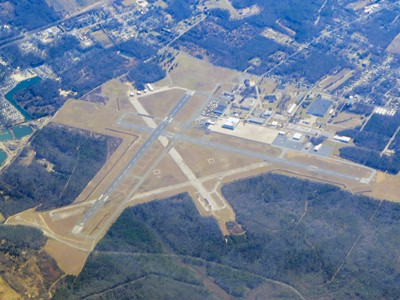
| Facility Name: | CAPE MAY COUNTY |
| City Name: | WILDWOOD |
| County: | CAPE MAY |
| State abbrev: | NJ |
| State Name: | NEW JERSEY |
| | |
| Ownership: | PUBLICLY OWNED |
| Use: | OPEN TO THE PUBLIC |
| Owner's Name: | DELAWARE RIVER BAY AUTHORITY; DRBA IS LESSEE. PROPERTY OWNED BY CAPE MAY COUNTY, PO BOX 365, CAPE MAY COURT HOUSE, N.J. 08210. 609-886-0901. |
| Address: | PO BOX 71 |
| | NEW CASTLE, DE 19720 |
| Owner's Phone: | 302-571-1237 |
| | |
| Manager's Name: | JOE MULHERON |
| Address: | 507 TERMINAL DRIVE BLDG #102, OPERATIONS |
| | RIO GRANDE, NJ 08242 |
| Phone: | 609-886-8652 |
| | |
| FAA Region: | EASTERN |
| FAA Field Office: | HAR |
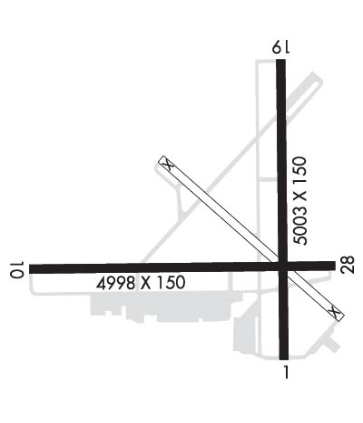
Runway Identifications
Runway Identification: 01/19Length: 5252 ft
Width: 150 ft
Surface: ASPHALT-GOOD CONDITION
Edge lights: High IntensityTreatment: NONE
| | Runway: 01 | | Runway: 19 |
| Mag heading: | 10° | Mag heading: | 190° |
| Rwy Slope: | -.12% Down | Rwy Slope: | .12% Up |
| Approach: | | Approach: | LOCALIZER |
| Pattern: | Left Traffic | Pattern: | Left Traffic |
| Markings: | NONPRECISION INSTRUMENT | Markings: | NONPRECISION INSTRUMENT |
| Marking Condition: | GOOD | Marking Condition: | GOOD |
| Arresting Dev: | | Arresting Dev: | |
| Lat & Long: | N3900.1 W07454.3 | Lat. & Long.: | N3901.0 W07454.3 |
| Elev: | 21.7 ft. MSL | Elev: | 15.2 ft. MSL |
| TCH: | 40 ft. AGL | TCH: | 40 ft. AGL |
| Visual Glide Path: | 3.00 degrees | Visual Glide Path: | 3.00 degrees |
| Displaced Threshold: | No | Displaced Threshold: | 215 feet |
| Touchdown Zone: | YES | Touchdown Zone: | YES |
| Touchdown Elev.: | 21.7 feet | Touchdown Elev.: | 18.5 feet |
| Visual Glide Slope: | 4-Light PAPI on LEFT side of Runway | Visual Glide Slope: | 4-Light PAPI on LEFT side of Runway |
| RVR Equipment: | | RVR Equipment: | |
| RVV Equipment: | NO | RVV Equipment: | NO |
| Approach Lights: | | Approach Lights: | |
| REIL: | NO | REIL: | NO |
| Centerline Lights: | NO | Centerline Lights: | NO |
| Touchdown lights: | NO | Touchdown lights: | NO |
| Runway Category: | Runway with a Non-precision Approach having visibility minimums greater than 3/4 mile | Runway Category: | Runway with a Non-precision Approach having visibility minimums greater than 3/4 mile |
| Declared Distances: | TORA:5252' TODA:5252' ASDA:5036' LDA:5036' | Declared Distances: | TORA:5252' TODA:5252' ASDA:5252' LDA:5036' |
| Obstructions: | TREE | Obstructions: | ROAD |
| Marked: | NOT Marked/Lighted | Marked: | NOT Marked/Lighted |
| Clearance slope: | 17:1 | Clearance slope: | 4:1; APCH RATIO 22:1 TO DSPLCD THR. |
| Obstruction height: | 55 feet AGL | Obstruction height: | 13 feet AGL |
| Dist. from runway: | 1140 feet | Dist. from runway: | 260 feet |
| Centerline offset: | 130 left of centerline | Centerline offset: | |
| Comments: | | Comments: | |
Runway Identification: 10/28Length: 5000 ft
Width: 150 ft
Surface: ASPHALT-GOOD CONDITION
Edge lights: Medium IntensityTreatment: NONE
| | Runway: 10 | | Runway: 28 |
| Mag heading: | 100° | Mag heading: | 280° |
| Rwy Slope: | .07% Up | Rwy Slope: | -.07% Down |
| Approach: | | Approach: | |
| Pattern: | Left Traffic | Pattern: | Left Traffic |
| Markings: | NONPRECISION INSTRUMENT | Markings: | NONPRECISION INSTRUMENT |
| Marking Condition: | GOOD | Marking Condition: | GOOD |
| Arresting Dev: | | Arresting Dev: | |
| Lat & Long: | N3900.4 W07455.2 | Lat. & Long.: | N3900.4 W07454.2 |
| Elev: | 15.5 ft. MSL | Elev: | 19.0 ft. MSL |
| TCH: | 45 ft. AGL | TCH: | 57 ft. AGL |
| Visual Glide Path: | 3.00 degrees | Visual Glide Path: | 3.00 degrees |
| Displaced Threshold: | No | Displaced Threshold: | No |
| Touchdown Zone: | YES | Touchdown Zone: | YES |
| Touchdown Elev.: | 17.6 feet | Touchdown Elev.: | 19.3 feet |
| Visual Glide Slope: | 4-Light PAPI on LEFT side of Runway | Visual Glide Slope: | 4-Light PAPI on LEFT side of Runway |
| RVR Equipment: | | RVR Equipment: | |
| RVV Equipment: | NO | RVV Equipment: | NO |
| Approach Lights: | | Approach Lights: | |
| REIL: | NO | REIL: | NO |
| Centerline Lights: | NO | Centerline Lights: | NO |
| Touchdown lights: | NO | Touchdown lights: | NO |
| Runway Category: | Runway with a Non-precision Approach having visibility minimums greater than 3/4 mile | Runway Category: | Runway with a Non-precision Approach having visibility minimums greater than 3/4 mile |
| Declared Distances: | | Declared Distances: | |
| Obstructions: | TREES | Obstructions: | TOWER |
| Marked: | NOT Marked/Lighted | Marked: | NOT Marked/Lighted |
| Clearance slope: | 22:1 | Clearance slope: | 30:1 |
| Obstruction height: | 80 feet AGL | Obstruction height: | 297 feet AGL |
| Dist. from runway: | 2000 feet | Dist. from runway: | 9290 feet |
| Centerline offset: | | Centerline offset: | 660 feet right of centerline |
| Comments: | | Comments: | |