Current Weather/Notams (Metars, TAFs, Notams, NWS Forecast, PIREPS, and nearby weather)
Customs Information Send updates to Support@FltPlan.com
Customs Not Available
Database effective 04/18/2024
Airport Diagram might not be current. Facility Name: WATERVILLE ROBERT LAFLEUR City Name: WATERVILLE County: KENNEBEC State abbrev: ME State Name: MAINE Ownership: PUBLICLY OWNED Use: OPEN TO THE PUBLIC Owner's Name: CITY OF WATERVILLE Address: 1 COMMON ST WATERVILLE, ME 04901 Owner's Phone: 207-861-8013 Manager's Name: RANDY MARSHALL JR Address: 2 LAFLUER RD WATERVILLE, ME 04901 Phone: 207-861-8013; EMAIL: AIRPORT@WATERVILLE-ME.GOV. FAA Region: NEW ENGLAND FAA Field Office: NONE
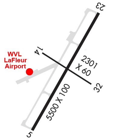
Runway Identifications Help
Runway Identification: 05/23 Length: 5500 ftWidth: 100 ftSurface: ASPHALTEdge lights: High Intensity Treatment: GROOVED Runway: 05 Runway: 23 Mag heading: 47° Mag heading: 227° Rwy Slope: 1.18% Up Rwy Slope: -1.18% Down Approach: ILS/DME Approach: Pattern: Left Traffic Pattern: Left Traffic Markings: PRECISION INSTRUMENT Markings: PRECISION INSTRUMENT Marking Condition: GOOD Marking Condition: GOOD Arresting Dev: Arresting Dev: Lat & Long: N4431.6 W06940.8 Lat. & Long.: N4432.4 W06940.2 Elev: 267.9 ft. MSL Elev: 332.8 ft. MSL TCH: 51 ft. AGL TCH: 40 ft. AGL Visual Glide Path: 3.00 degrees Visual Glide Path: 3.00 degrees Displaced Threshold: No Displaced Threshold: No Touchdown Zone: YES Touchdown Zone: YES Touchdown Elev.: 308.6 feet Touchdown Elev.: 332.8 feet Visual Glide Slope: 4-BOX VASI ON LEFT SIDE OF RUNWAY Visual Glide Slope: 4-Light PAPI on LEFT side of Runway RVR Equipment: RVR Equipment: RVV Equipment: NO RVV Equipment: NO Approach Lights: MALSF - 1,400 foot medium intensity approach lighting system with sequenced flashers Approach Lights: REIL: NO REIL: YES Centerline Lights: NO Centerline Lights: NO Touchdown lights: NO Touchdown lights: NO Runway Category: Precision Instrument Runway Runway Category: Runway with a Non-precision Approach having visibility minimums greater than 3/4 mile Declared Distances: Declared Distances:
Runway Identification: 14/32 Length: 2301 ftWidth: 60 ftSurface: ASPHALTEdge lights: Treatment: NONE Runway: 14 Runway: 32 Mag heading: 143° Mag heading: 323° Rwy Slope: -.39% Down Rwy Slope: .39% Up Approach: Approach: Pattern: Left Traffic Pattern: Left Traffic Markings: BASIC Markings: BASIC Marking Condition: FAIR Marking Condition: FAIR Arresting Dev: Arresting Dev: Lat & Long: N4432.1 W06940.7 Lat. & Long.: N4431.9 W06940.3 Elev: 307.6 ft. MSL Elev: 298.6 ft. MSL TCH: TCH: Visual Glide Path: Visual Glide Path: Displaced Threshold: No Displaced Threshold: No Touchdown Zone: YES Touchdown Zone: YES Touchdown Elev.: 307.6 feet Touchdown Elev.: 307.6 feet Visual Glide Slope: Visual Glide Slope: RVR Equipment: RVR Equipment: RVV Equipment: NO RVV Equipment: NO Approach Lights: Approach Lights: REIL: NO REIL: NO Centerline Lights: NO Centerline Lights: NO Touchdown lights: NO Touchdown lights: NO Runway Category: Runway with a Visual Approach Runway Category: Runway with a Visual Approach Declared Distances: Declared Distances: Obstructions: TREES Obstructions: Marked: NOT Marked/Lighted Marked: Clearance slope: 13:1 Clearance slope: 20:1 Obstruction height: 15 feet AGL Obstruction height: Dist. from runway: 402 feet Dist. from runway: Centerline offset: 50 left of centerline Centerline offset: Comments: Comments: