Current Weather/Notams (Metars, TAFs, Notams, NWS Forecast, PIREPS, and nearby weather)
Customs Information Send updates to Support@FltPlan.com
Customs Not Available
Database effective 05/16/2024
Airport Diagram might not be current.
|
| Facility Name: | WATSONVILLE MUNI |
| City Name: | WATSONVILLE |
| County: | SANTA CRUZ |
| State abbrev: | CA |
| State Name: | CALIFORNIA |
| | |
| Ownership: | PUBLICLY OWNED |
| Use: | OPEN TO THE PUBLIC |
| Owner's Name: | CITY OF WATSONVILLE |
| Address: | 275 MAIN ST |
| | WATSONVILLE, CA 95076 |
| Owner's Phone: | 831-768-3000 |
| | |
| Manager's Name: | RAYVON WILLIAMS; RAYVON.WILLIAMS@CITYOFWATSONVILLE.ORG |
| Address: | 100 AVIATION WAY |
| | WATSONVILLE, CA 95076 |
| Phone: | 831-768-3575 |
| | |
| FAA Region: | WESTERN-PACIFIC |
| FAA Field Office: | SFO |
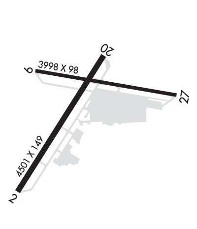
Runway Identifications
Runway Identification: 02/20Length: 4502 ft
Width: 149 ft
Surface: ASPHALT-FAIR CONDITION
Edge lights: Medium IntensityTreatment: NONE
| | Runway: 02 | | Runway: 20 |
| Mag heading: | 18° | Mag heading: | 198° |
| Rwy Slope: | .40% Up | Rwy Slope: | -.40% Down |
| Approach: | LOCALIZER | Approach: | |
| Pattern: | Left Traffic | Pattern: | Left Traffic |
| Markings: | NONPRECISION INSTRUMENT | Markings: | NONPRECISION INSTRUMENT |
| Marking Condition: | FAIR | Marking Condition: | FAIR |
| Arresting Dev: | | Arresting Dev: | |
| Lat & Long: | N3655.7 W12147.7 | Lat. & Long.: | N3656.4 W12147.3 |
| Elev: | 139.5 ft. MSL | Elev: | 157.7 ft. MSL |
| TCH: | 43 ft. AGL | TCH: | 44 ft. AGL |
| Visual Glide Path: | 3.00 degrees | Visual Glide Path: | 3.00 degrees |
| Displaced Threshold: | No | Displaced Threshold: | 589 feet |
| Touchdown Zone: | YES | Touchdown Zone: | YES |
| Touchdown Elev.: | 151.7 feet | Touchdown Elev.: | 155.4 feet |
| Visual Glide Slope: | 2-Light PAPI on LEFT side of Runway | Visual Glide Slope: | 2-Light PAPI on LEFT side of Runway; UNUSBL BYD 4.0 NM DUE TO TERRAIN. |
| RVR Equipment: | | RVR Equipment: | |
| RVV Equipment: | NO | RVV Equipment: | NO |
| Approach Lights: | | Approach Lights: | |
| REIL: | YES | REIL: | NO |
| Centerline Lights: | NO | Centerline Lights: | NO |
| Touchdown lights: | NO | Touchdown lights: | NO |
| Runway Category: | Runway with a Non-precision Approach having visibility minimums greater than 3/4 mile | Runway Category: | Runway with a Visual Approach |
| Declared Distances: | | Declared Distances: | |
| Obstructions: | TREES | Obstructions: | TREE |
| Marked: | NOT Marked/Lighted | Marked: | NOT Marked/Lighted |
| Clearance slope: | 24:1 | Clearance slope: | 12:1; RWY 20 APCH RATIO 22:1 TO DSPLCD THR. |
| Obstruction height: | 46 feet AGL | Obstruction height: | 80 feet AGL |
| Dist. from runway: | 1310 feet | Dist. from runway: | 1198 feet |
| Centerline offset: | 39 left of centerline | Centerline offset: | 125 feet left of centerline |
| Comments: | | Comments: | |
Runway Identification: 09/27Length: 3998 ft
Width: 98 ft
Surface: ASPHALT-FAIR CONDITION
Edge lights: Treatment: NONE
| | Runway: 09 | | Runway: 27 |
| Mag heading: | 86° | Mag heading: | 266° |
| Rwy Slope: | -.68% Down | Rwy Slope: | .68% Up |
| Approach: | | Approach: | |
| Pattern: | Left Traffic | Pattern: | Left Traffic |
| Markings: | BASIC | Markings: | BASIC |
| Marking Condition: | FAIR | Marking Condition: | FAIR |
| Arresting Dev: | | Arresting Dev: | |
| Lat & Long: | N3656.3 W12147.6 | Lat. & Long.: | N3656.2 W12146.8 |
| Elev: | 163.3 ft. MSL | Elev: | 136.3 ft. MSL |
| TCH: | 34 ft. AGL | TCH: | |
| Visual Glide Path: | 4.00 degrees | Visual Glide Path: | |
| Displaced Threshold: | No | Displaced Threshold: | No |
| Touchdown Zone: | YES | Touchdown Zone: | YES |
| Touchdown Elev.: | 163.3 feet | Touchdown Elev.: | 157.5 feet |
| Visual Glide Slope: | 2-Light PAPI on RIGHT side of Runway | Visual Glide Slope: | |
| RVR Equipment: | | RVR Equipment: | |
| RVV Equipment: | NO | RVV Equipment: | NO |
| Approach Lights: | | Approach Lights: | |
| REIL: | NO | REIL: | NO |
| Centerline Lights: | NO | Centerline Lights: | NO |
| Touchdown lights: | NO | Touchdown lights: | NO |
| Runway Category: | Runway with a Visual Approach | Runway Category: | Runway with a Visual Approach |
| Declared Distances: | | Declared Distances: | |
| Obstructions: | TREE | Obstructions: | TREE |
| Marked: | NOT Marked/Lighted | Marked: | NOT Marked/Lighted |
| Clearance slope: | 22:1 | Clearance slope: | 13:1 |
| Obstruction height: | 38 feet AGL | Obstruction height: | 55 feet AGL |
| Dist. from runway: | 1050 feet | Dist. from runway: | 935 feet |
| Centerline offset: | | Centerline offset: | 40 feet right of centerline |
| Comments: | | Comments: | |

