Current Weather/Notams (Metars, TAFs, Notams, NWS Forecast, PIREPS, and nearby weather)
Customs Information Send updates to Support@FltPlan.com
Customs Not Available
Database effective 04/18/2024
Airport Diagram might not be current.
|
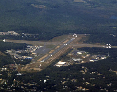
| Facility Name: | WESTERLY STATE |
| City Name: | WESTERLY |
| County: | WASHINGTON |
| State abbrev: | RI |
| State Name: | RHODE ISLAND |
| | |
| Ownership: | PUBLICLY OWNED |
| Use: | OPEN TO THE PUBLIC |
| Owner's Name: | RHODE ISLAND AIRPORT CORPORATION |
| Address: | 2000 POST RD |
| | WARWICK, RI 02886 |
| Owner's Phone: | 401-691-2265 |
| | |
| Manager's Name: | IFTIKHAR AHMAD |
| Address: | RHODE ISLAND AIRPORT CORP, 2000 POST RD |
| | WARWICK, RI 02886 |
| Phone: | 401-691-2265 |
| | |
| FAA Region: | NEW ENGLAND |
| FAA Field Office: | NONE |
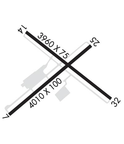
Runway Identifications
Runway Identification: 07/25Length: 4010 ft
Width: 100 ft
Surface: ASPHALT-POOR CONDITION
Edge lights: Medium IntensityTreatment: GROOVED
| | Runway: 07 | | Runway: 25 |
| Mag heading: | 68° | Mag heading: | 248° |
| Rwy Slope: | .68% Up | Rwy Slope: | -.68% Down |
| Approach: | LOC/DME | Approach: | |
| Pattern: | Left Traffic | Pattern: | Left Traffic |
| Markings: | BASIC | Markings: | NONPRECISION INSTRUMENT |
| Marking Condition: | FAIR | Marking Condition: | FAIR |
| Arresting Dev: | | Arresting Dev: | |
| Lat & Long: | N4120.7 W07148.6 | Lat. & Long.: | N4121.1 W07147.9 |
| Elev: | 51.1 ft. MSL | Elev: | 78.3 ft. MSL |
| TCH: | 46 ft. AGL | TCH: | 36 ft. AGL |
| Visual Glide Path: | 3.50 degrees | Visual Glide Path: | 3.50 degrees |
| Displaced Threshold: | TEMPO DTHR 375 FT. | Displaced Threshold: | No |
| Touchdown Zone: | YES | Touchdown Zone: | YES |
| Touchdown Elev.: | 75.5 feet | Touchdown Elev.: | 78.3 feet |
| Visual Glide Slope: | 4-Light PAPI on RIGHT side of Runway; PAPI U/S. | Visual Glide Slope: | 2-Box VASI on LEFT side of Runway |
| RVR Equipment: | | RVR Equipment: | |
| RVV Equipment: | NO | RVV Equipment: | NO |
| Approach Lights: | MALSF - 1,400 foot medium intensity approach lighting system with sequenced flashers | Approach Lights: | |
| REIL: | NO | REIL: | YES |
| Centerline Lights: | NO | Centerline Lights: | NO |
| Touchdown lights: | NO | Touchdown lights: | NO |
| Runway Category: | Runway with a Non-precision Approach having visibility minimums greater than 3/4 mile | Runway Category: | Runway with a Visual Approach |
| Declared Distances: | | Declared Distances: | |
| Obstructions: | TREES | Obstructions: | TREES |
| Marked: | NOT Marked/Lighted | Marked: | NOT Marked/Lighted |
| Clearance slope: | 17:1; 22:1 TO TEMPO DTHR. | Clearance slope: | 18:1 |
| Obstruction height: | 117 feet AGL | Obstruction height: | 48 feet AGL |
| Dist. from runway: | 2200 feet | Dist. from runway: | 1100 feet |
| Centerline offset: | 330 right of centerline | Centerline offset: | 40 feet left of centerline |
| Comments: | | Comments: | +10 FT TREES, 170 FT - 200 FT FM THR, 180 FT L. |
Runway Identification: 14/32Length: 3960 ft
Width: 75 ft
Surface: ASPHALT-POOR CONDITION
Edge lights: Medium IntensityTreatment: NONE
| | Runway: 14 | | Runway: 32 |
| Mag heading: | 145° | Mag heading: | 325° |
| Rwy Slope: | .61% Up | Rwy Slope: | -.61% Down |
| Approach: | | Approach: | |
| Pattern: | Left Traffic | Pattern: | Left Traffic |
| Markings: | BASIC | Markings: | BASIC |
| Marking Condition: | FAIR | Marking Condition: | FAIR |
| Arresting Dev: | | Arresting Dev: | |
| Lat & Long: | N4121.2 W07148.5 | Lat. & Long.: | N4120.8 W07147.8 |
| Elev: | 56.9 ft. MSL | Elev: | 81.1 ft. MSL |
| TCH: | 40 ft. AGL | TCH: | 40 ft. AGL |
| Visual Glide Path: | 4.00 degrees | Visual Glide Path: | 4.00 degrees |
| Displaced Threshold: | TEMPO DTHR 595 FT. | Displaced Threshold: | 750 feet |
| Touchdown Zone: | YES | Touchdown Zone: | YES |
| Touchdown Elev.: | 76.3 feet | Touchdown Elev.: | 78.2 feet |
| Visual Glide Slope: | 4-Light PAPI on LEFT side of Runway; PAPI U/S. | Visual Glide Slope: | 4-Light PAPI on LEFT side of Runway |
| RVR Equipment: | | RVR Equipment: | |
| RVV Equipment: | NO | RVV Equipment: | NO |
| Approach Lights: | | Approach Lights: | |
| REIL: | YES | REIL: | YES |
| Centerline Lights: | NO | Centerline Lights: | NO |
| Touchdown lights: | NO | Touchdown lights: | NO |
| Runway Category: | Runway with a Visual Approach | Runway Category: | Runway with a Visual Approach |
| Declared Distances: | | Declared Distances: | |
| Obstructions: | TREES | Obstructions: | TREES |
| Marked: | NOT Marked/Lighted | Marked: | NOT Marked/Lighted |
| Clearance slope: | 10:1; 22:1 TO TEMPO DTHR. | Clearance slope: | 6:1; 22:1 TO DTHR. |
| Obstruction height: | 17 feet AGL | Obstruction height: | 33 feet AGL |
| Dist. from runway: | 380 feet | Dist. from runway: | 425 feet |
| Centerline offset: | 140 left of centerline | Centerline offset: | 100 feet left of centerline |
| Comments: | +10 FT TREES, 100 FT FM THR, 110 FT L; +10 FT TREES, 100 FT FM THR, 120 FT R. | Comments: | +20 FT TREES, 200 FT FM THR, 125 FT L. |