
| ||||||||||||||||||||||||||||||||||||||||||||
| ||||||||||||||||||||||||||||||||||||||||||||
| ||||||||||||||||||||||||||||||||||||||||||||
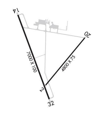
| Rwy | Rwy | |||||||
| 4800x75 | 4800' | 4800x75 | 4800' | |||||
| 7000x100 | 7000' | 7000x100 | 7000' | |||||
| Runway ID | Single Wheel | Double Wheel | Double Tandem Wheel | Dual Double Wheel |
| 02/20 | 28,000 | N/A | N/A | N/A |
| 14/32 | 75,000 | 125,000 | 200,000 | N/A |
| H1 | N/A | N/A | N/A | N/A |
| H2 | N/A | N/A | N/A | N/A |
| These numbers are Advisory and are not limits. The Airport Manager should have more accurate Weight Limits | ||||
 Airport Diagram might not be current. | |
| Facility Name: | WINNEMUCCA MUNI |
| City Name: | WINNEMUCCA |
| County: | HUMBOLDT |
| State abbrev: | NV |
| State Name: | NEVADA |
| Ownership: | PUBLICLY OWNED |
| Use: | OPEN TO THE PUBLIC |
| Owner's Name: | CITY/COUNTY OF WINNEMUCCA |
| Address: | 90 WEST 4TH STREET |
| WINNEMUCCA, NV 89445 | |
| Owner's Phone: | 775-623-6333 |
| Manager's Name: | ALICIA HEISER; FBO - WINNEMUCCA AIR SERVICE 775-623-5091. |
| Address: | 90 WEST FOURTH STREET |
| WINNEMUCCA, NV 89445 | |
| Phone: | 775-623-6333 |
| FAA Region: | WESTERN-PACIFIC |
| FAA Field Office: | PHX |

| Date | Sunrise | Sunset |
|---|---|---|
| 04/15/24 Monday | 6:11 | 19:32 |
| 04/16/24 Tuesday | 6:09 | 19:33 |
| 04/17/24 Wednesday | 6:08 | 19:34 |
| 04/18/24 Thursday | 6:06 | 19:35 |
| 04/19/24 Friday | 6:05 | 19:36 |
| 04/20/24 Saturday | 6:03 | 19:37 |
| 04/21/24 Sunday | 6:02 | 19:38 |
| 04/22/24 Monday | 6:01 | 19:39 |
| 04/23/24 Tuesday | 5:59 | 19:40 |
| 04/24/24 Wednesday | 5:58 | 19:41 |
| 04/25/24 Thursday | 5:56 | 19:42 |
| 04/26/24 Friday | 5:55 | 19:43 |
| 04/27/24 Saturday | 5:54 | 19:44 |
| 04/28/24 Sunday | 5:52 | 19:46 |
| Airport Attendance Schedule | NOV-MAY MON -FRI 0800-1700, JUN-OCT 7 Days A Week 0700-1800; AFT HRS OR EMERG CALL (775) 304-5885. |
| Airport Status | OPERATIONAL (This Status can change at any time - please check NOTAMS) |
| Airport Lighting Schedule | MIRL RY 14/32 PRESET LOW INTST; TO INCR INTST ACTVT - CTAF. |
| Airport Storage Available | Tie Downs, Hanger |
| Extra Services Available | Air Ambulance, Flight Instruction, Aircraft Rental |
| Wind Indicator | YES - (lighted) |
| Control Tower | NO |
| CTAF Frequency | 122.800 |
| Unicom Frequency | 122.800 |
| Rotating Beacon Color | WG |
| Segmented Circle | YES |
| Landing Fee | NO |
| Airport Inspected | STATE - performed by STATE AERONAUTICAL PERSONNEL |
| Inspection Date | 09/28/2022 |
| Type of Fuel Available | Grade 100LL, JET A (freeze point -40C) |
| Airframe Repair Service | MINOR |
| Power Plant Repair Service | MINOR |
| Latitude | N4053.8 |
| Longitude | W11748.4 (ESTIMATED) |
| Arpt Elevation | 4307ft (SURVEYED) |
| Magnetic Variation | 16E |
| 5 miles SW | of WINNEMUCCA |
| Traffic Pattern Altitude | 800 |
| Sectional Chart | KLAMATH FALLS |
| Operations (Reported) | Yearly | Avg. Daily |
|---|---|---|
| General Aviation Transient | 2920 | 8 |
| General Aviation Local | 1825 | 5 |
| Air Taxi | 1800 | 5 |
| Commerical | 0 | 0 |
| Commuter | 0 | 0 |
| Military | 380 | 1 |
| Aircraft based on Field | |
|---|---|
| General Aviation Singles | 10 |
| General Aviation Multi | 0 |
| Jet Aircraft | 0 |
| General Aviation Helicopters | 0 |
| Military Aircraft | 0 |
| Gliders | 0 |
| Ultralights | 4 |
| FSS on field | NO |
| FSS tie-in | RENO |
| FSS Phone | 1-800-WX-BRIEF |
| Who issues Notams | WMC |
| Notam D service at airport | YES |
| ARTCC Name | SALT LAKE CITY |
| Airport Certification | |
| Aircraft Rescue & Firefighting Index | None |
| Airport of Entry | No |
| Custom Landing Rights | No |
| Joint Civil/Military | No |
| Military Landing rights | YES |
| NATIONAL PLAN OF INTEGRATED AIRPORT SYSTEMS (NPIAS) |
| GRANT AGREEMENTS UNDER FAAP/ADAP/AIP |
| ASSURANCES PURSUANT TO TITLE VI, CIVIL RIGHTS ACT OF 1964 |
| SECTION 303(C) AUTHORITY FROM FAA ACT OF 1958 HAS EXPIRED; HOWEVER, AGREEMENT REMAINS IN EFFECT FOR THIS FACILITY AS LONG AS IT IS PUBLIC USE. |
| FULL STRENGTH PAVEMENT AREAS INCLUDE N 1000 FT OF PARALLEL TWY (RY 14/32 TO TWY A); W 1000 FT OF TWY A; 600 FT OF N/S TWR (FM TWY A). |
| MOUNTAINS IN SW QUADRANT. |
| CALL FBO FOR CURRENT RWY CONDS IN WINTER MONTHS. |
| FOR CD IF UNA TO CTC ON FSS FREQ, CTC SALT LAKE ARTCC AT 801-320-2568. |
| RWY H1 UNMRKD 25 FT X 25 FT CONCRETE TLOF ADJACENT TO APRON PRKG AND TWY ALPHA. |
| RWY H2 H2 ADJACENT TO APRON PRKG AND TAXIWAY ALPHA |
Airport Communications & Frequencies:
| |||||||||
| Runway: 02 | Runway: 20 | ||
| Mag heading: | 24° | Mag heading: | 204° |
| Rwy Slope: | .09% Up | Rwy Slope: | -.09% Down |
| Approach: | Approach: | ||
| Pattern: | Left Traffic | Pattern: | Left Traffic |
| Markings: | BASIC | Markings: | BASIC |
| Marking Condition: | GOOD | Marking Condition: | GOOD |
| Arresting Dev: | Arresting Dev: | ||
| Lat & Long: | N4053.5 W11748.4 | Lat. & Long.: | N4054.1 W11747.7 |
| Elev: | 4303.0 ft. MSL | Elev: | 4307.4 ft. MSL |
| TCH: | TCH: | 40 ft. AGL | |
| Visual Glide Path: | Visual Glide Path: | 3.00 degrees | |
| Displaced Threshold: | No | Displaced Threshold: | No |
| Touchdown Zone: | YES | Touchdown Zone: | YES |
| Touchdown Elev.: | 4306.7 feet | Touchdown Elev.: | 4307.6 feet |
| Visual Glide Slope: | Visual Glide Slope: | 2-Light PAPI on LEFT side of Runway | |
| RVR Equipment: | RVR Equipment: | ||
| RVV Equipment: | NO | RVV Equipment: | NO |
| Approach Lights: | Approach Lights: | ||
| REIL: | NO | REIL: | YES |
| Centerline Lights: | NO | Centerline Lights: | NO |
| Touchdown lights: | NO | Touchdown lights: | NO |
| Runway Category: | Runway with a Visual Approach | Runway Category: | Runway with a Visual Approach |
| Declared Distances: | Declared Distances: | ||
| Obstructions: | Obstructions: | ROAD | |
| Marked: | Marked: | NOT Marked/Lighted | |
| Clearance slope: | 50:1 | Clearance slope: | 25:1 |
| Obstruction height: | Obstruction height: | 12 feet AGL | |
| Dist. from runway: | Dist. from runway: | 500 feet | |
| Centerline offset: | Centerline offset: | ||
| Comments: | Comments: |
| Runway: 14 | Runway: 32 | ||
| Mag heading: | 144° | Mag heading: | 324° |
| Rwy Slope: | .03% Up | Rwy Slope: | -.03% Down |
| Approach: | Approach: | ||
| Pattern: | Left Traffic | Pattern: | Left Traffic |
| Markings: | NONPRECISION INSTRUMENT | Markings: | NONPRECISION INSTRUMENT |
| Marking Condition: | FAIR | Marking Condition: | FAIR |
| Arresting Dev: | Arresting Dev: | ||
| Lat & Long: | N4054.4 W11748.8 | Lat. & Long.: | N4053.3 W11748.3 |
| Elev: | 4301.4 ft. MSL | Elev: | 4303.2 ft. MSL |
| TCH: | 40 ft. AGL | TCH: | 40 ft. AGL |
| Visual Glide Path: | 3.00 degrees | Visual Glide Path: | 3.00 degrees |
| Displaced Threshold: | No | Displaced Threshold: | No |
| Touchdown Zone: | YES | Touchdown Zone: | YES |
| Touchdown Elev.: | 4303.8 feet | Touchdown Elev.: | 4303.8 feet |
| Visual Glide Slope: | 2-Light PAPI on LEFT side of Runway | Visual Glide Slope: | 2-Light PAPI on LEFT side of Runway |
| RVR Equipment: | RVR Equipment: | ||
| RVV Equipment: | NO | RVV Equipment: | NO |
| Approach Lights: | Approach Lights: | ||
| REIL: | YES | REIL: | YES |
| Centerline Lights: | NO | Centerline Lights: | NO |
| Touchdown lights: | NO | Touchdown lights: | NO |
| Runway Category: | Runway with a Non-precision Approach having visibility minimums greater than 3/4 mile | Runway Category: | D |
| Declared Distances: | Declared Distances: | ||
| Obstructions: | PLINE | Obstructions: | |
| Marked: | MARKED | Marked: | |
| Clearance slope: | 26:1 | Clearance slope: | 50:1 |
| Obstruction height: | 30 feet AGL | Obstruction height: | |
| Dist. from runway: | 1000 feet | Dist. from runway: | |
| Centerline offset: | Centerline offset: | ||
| Comments: | Comments: |